Paper I — Q2
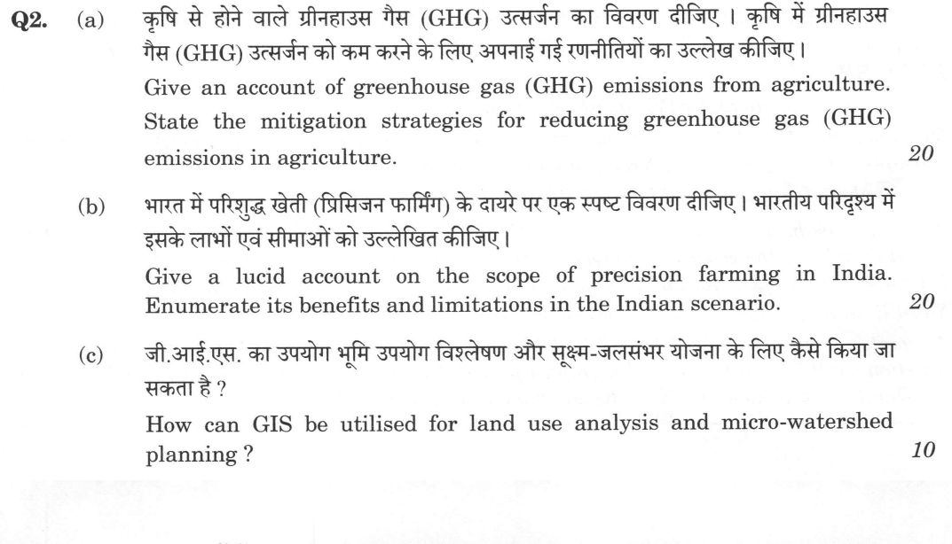
(a) Give an account of greenhouse gas (GHG) emissions from agriculture. State the mitigation strategies for reducing greenhouse…
Give an account of greenhouse gas (GHG) emissions from agriculture. State the mitigation strategies for reducing greenhouse gas (GHG) emissions in agriculture. 20 marks
Give a lucid account on the scope of precision farming in India. Enumerate its benefits and limitations in the Indian scenario. 20 marks
How can GIS be utilised for land use analysis and micro-watershed planning ? 10 marks
हिंदी में प्रश्न पढ़ें
कृषि से होने वाले ग्रीनहाउस गैस (GHG) उत्सर्जन का विवरण दीजिए। कृषि में ग्रीनहाउस गैस (GHG) उत्सर्जन को कम करने के लिए अपनाई गई रणनीतियों का उल्लेख कीजिए। (20 अंक)
भारत में परिशुद्ध खेती (प्रिसिजन फार्मिंग) के दायरे पर एक स्पष्ट विवरण दीजिए। भारतीय परिदृश्य में इसके लाभों एवं सीमाओं को उल्लेखित कीजिए। (20 अंक)
जी.आई.एस. का उपयोग भूमि उपयोग विश्लेषण और सूक्ष्म-जलसंभर योजना के लिए कैसे किया जा सकता है ? (10 अंक)
Model answer
Drafted with AI by UPSC Answer Check against this question's marking rubric, to the expected length. UPSC does not publish answers for Mains — this is one way to score well, not an official key. How we build rubrics and answers.
(a) Greenhouse gas emissions from agriculture and mitigation strategies (20 marks)
Emissions. Agriculture releases mainly methane and nitrous oxide, with some carbon dioxide, and accounts for roughly one-seventh of India's national emissions.
- Methane (CH4), with a warming effect about 28 times that of CO2 over a century: from enteric fermentation in ruminants (the largest agricultural source in India, given the very large cattle and buffalo population), from flooded rice fields where anaerobic decomposition of organic matter produces it, and from manure storage.
- Nitrous oxide (N2O), about 270 times as potent as CO2: from nitrification and denitrification of soil nitrogen, chiefly synthetic nitrogen fertiliser (mostly urea), manure and crop residues, and from waterlogged soils.
- Carbon dioxide: from burning of crop residues (also releasing black carbon and methane), oxidation of soil organic matter under intensive tillage, fossil fuel use in pumps and machinery, fertiliser manufacture, and land-use change such as deforestation.
Mitigation strategies:
- Rice: alternate wetting and drying, the system of rice intensification, direct-seeded and aerobic rice, mid-season drainage, low-methane varieties, and use of ammonium-based or sulphate-containing fertilisers.
- Livestock: better feed and balanced rations, fodder improvement, feed additives and supplements that reduce enteric methane (such as the anti-methanogenic supplement developed by ICAR), genetic improvement to raise productivity per animal and reduce numbers of unproductive animals, and biogas plants for manure.
- Nutrients: the 4R approach (right source, rate, time and place), soil-test-based use (Soil Health Card), neem-coated urea, nano fertilisers, nitrification inhibitors, split application, and legumes to replace fertiliser nitrogen.
- Residues and soil: in-situ management using Happy Seeder and incorporation, or ex-situ use for fuel, fodder and biochar rather than burning; conservation agriculture (zero tillage, mulch, cover crops) to build soil carbon.
- Agroforestry, and shelterbelts, for carbon sequestration; renewable energy (solar pumps under PM-KUSUM) and efficient irrigation, and energy-saving machinery.
- Policy: national programmes such as the National Mission for Sustainable Agriculture, climate-resilient agriculture research (NICRA) and the Green Credit Programme, with capacity building and monitoring of emissions. Many measures also raise productivity and farm income, giving mitigation with adaptation and food security.
(b) Precision farming in India (20 marks)
Scope. Precision farming is site-specific management that applies inputs at the right place, time and rate, guided by spatial and temporal variability in field conditions, using technology. Its components are the Global Navigation Satellite System (GPS), geographic information systems, remote sensing (satellite and drone imagery), soil and crop sensors, variable rate technology, yield monitors, Internet of Things devices, decision support systems and artificial intelligence. In India its scope covers:
- Soil and nutrient management through grid soil sampling, fertility mapping and variable-rate fertiliser application.
- Water management using drip irrigation and fertigation, sensor-based scheduling and soil moisture monitoring.
- Crop monitoring, growth-stage and stress detection, pest and disease forecasting, and yield estimation using drones and satellites; and spraying by drones (for example, under the Namo Drone Didi scheme).
- Suitable crops and systems: high-value horticulture, plantation crops, sugarcane, protected cultivation and vertical farming, cotton, and rice-wheat systems in irrigated tracts.
- Support from digital public infrastructure such as the Digital Agriculture Mission, Agri Stack and Krishi-DSS.
Benefits: higher input-use efficiency and savings in fertiliser, water, seed and pesticide; higher yield and quality; lower environmental pollution and emissions; reduction in production risk; better records and traceability; saving of labour; and improved farm profit.
Limitations in the Indian scenario: small and fragmented holdings (average about 1.1 hectares), which make machinery and sensors uneconomic; high initial cost and low affordability; low awareness, digital literacy and skill of farmers; poor rural connectivity and power; lack of local soil, weather and crop data and maps; weak extension and service providers for maintenance; unsuitability of some imported technology; and tenancy and uncertainty of land rights. Custom-hiring centres, farmer producer organisations, subsidy, training and low-cost indigenous technologies can extend its reach.
(c) GIS in land use analysis and micro-watershed planning (10 marks)
Land use analysis. GIS integrates spatial data in layers. Satellite images (such as IRS-LISS, Sentinel) are classified into land use and land cover, and change detection of successive dates shows shifts, for example loss of farmland or forest, expansion of built-up area and degradation. Overlay of soil, slope from a digital elevation model, climate, water and land-capability layers gives land suitability analysis and identifies wasteland and unused land for cropping, forestry or pasture; it supports crop planning, monitoring and policy-making.
Micro-watershed planning. GIS delineates watershed and micro-watershed boundaries and the drainage network from the elevation model, computes morphometric parameters such as stream order, drainage density and slope, and prioritises sub-watersheds by erosion risk (using the Universal Soil Loss Equation) and by runoff (curve number method). Overlays then select suitable sites for check dams, farm ponds, contour bunds and afforestation; and repeated imagery monitors treatment impact on vegetation, groundwater and soil moisture. The results support participatory planning under watershed programmes such as PMKSY, with data available from Bhuvan and the National Remote Sensing Centre.
How this answer will be evaluated
Evaluation rubric
Each sub-part is marked on its own, against the marks and word limit printed on the paper.
- (a) (a) Account of GHG emissions from agriculture; mitigation strategies (20). 20 marks
Must cover
- Sources: methane from enteric fermentation, rice fields and manure; N2O from fertiliser and manure; CO2 from residue burning, soil and energy
- Relative global-warming potentials or India's share of emissions
- Mitigation in rice: AWD, SRI, direct-seeded and aerobic rice
- Mitigation in livestock and nutrients: feed, additives, 4R nutrient management, neem-coated urea; residue and soil management, agroforestry, renewables
Loses marks
- Omitting either emissions or mitigation.
- Confusing greenhouse gases with ozone depletion.
- Mitigation with no link to a specific source.
Earns more
- Policy programmes such as NMSA, NICRA or the Green Credit Programme.
- Co-benefits for yield and income.
Extra mark
- Biochar and carbon markets
- (b) (b) Scope of precision farming in India; benefits and limitations in the Indian scenario (20). 20 marks
Must cover
- Definition and technology components: GPS, GIS, remote sensing, sensors, VRT, IoT, AI
- Scope: soil and nutrient, water, crop monitoring, drones, crops and systems suited, digital agriculture support
- Benefits: input efficiency, yield, environment, risk, traceability
- Limitations: small holdings, cost, skills, connectivity, data, service support, tenancy; ways forward
Loses marks
- Describing generic precision farming with no India-specific scope or limits.
- Only benefits or only limitations.
- Confusing precision farming with organic farming.
Earns more
- Indian schemes such as Digital Agriculture Mission or Namo Drone Didi.
- Balanced treatment of benefits and limits.
Extra mark
- Custom-hiring or FPO models
- (c) (c) How can GIS be used for land use analysis and micro-watershed planning? (10) 10 marks
Must cover
- Land use and land cover classification from satellite imagery and change detection
- Overlay analysis of soil, slope, climate and land capability for suitability
- Watershed delineation, morphometry and prioritisation using DEM, USLE, curve number
- Site selection of structures and monitoring impact; participatory use
Loses marks
- Defining GIS without application.
- Only land use or only watershed.
- Mixing GIS with GPS only.
Earns more
- Data sources such as Bhuvan or NRSC.
- Link to watershed programmes such as PMKSY.
Extra mark
- Web GIS or mobile applications
What "State" is asking you to do
Give the formulation itself — the theorem, rule, statutory provision or position — worded accurately. Precision of wording is the whole of the mark; no background or justification is being asked for.
Structure that answers it
The statement in full, complete in itself → the conditions under which it holds → an illustration only where the stem asks for one
Where marks are lost
Approximating the wording. A theorem or a provision stated loosely forfeits the mark that exact statement would have carried.
Practice this exact question
Write your answer and it is marked point by point against the model answer above — what you covered, what you missed, what you got wrong.
Evaluate my answer →More from Agriculture 2026 Paper I
- Q1 Answer the following questions in about 150 words each : (a) What are the major sources o…
- Q2 (a) Give an account of greenhouse gas (GHG) emissions from agriculture. State the mitigat…
- Q3 (a) Discuss the vegetative propagation methods adopted in forest plants with suitable exa…
- Q4 (a) What do you mean by soil consistency and soil plasticity ? Briefly discuss the variou…
- Q5 Answer the following questions in about 150 words each : (a) Write down the approaches fo…