Paper I — Q5
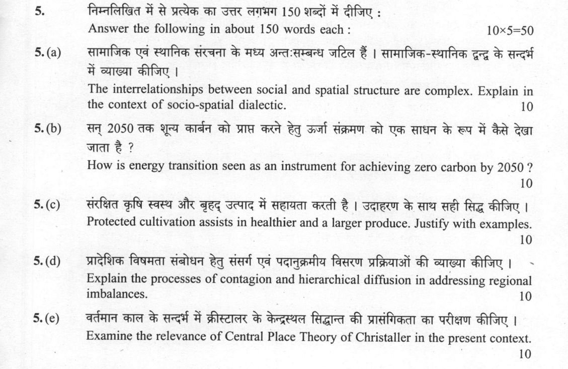
Answer the following in about 150 words each: (a) The interrelationships between social and spatial structure are complex…
Answer the following in about 150 words each: The interrelationships between social and spatial structure are complex. Explain in the context of socio-spatial dialectic. 10 marks
How is energy transition seen as an instrument for achieving zero carbon by 2050? 10 marks
Protected cultivation assists in healthier and a larger produce. Justify with examples. 10 marks
Explain the processes of contagion and hierarchical diffusion in addressing regional imbalances. 10 marks
Examine the relevance of Central Place Theory of Christaller in the present context. 10 marks
हिंदी में प्रश्न पढ़ें
निम्नलिखित में से प्रत्येक का उत्तर लगभग 150 शब्दों में दीजिए : सामाजिक एवं स्थानिक संरचना के मध्य अन्तःसम्बन्ध जटिल हैं। सामाजिक-स्थानिक द्वन्द्व के संदर्भ में व्याख्या कीजिए। (10 अंक)
सन् 2050 तक शून्य कार्बन को प्राप्त करने हेतु ऊर्जा संक्रमण को एक साधन के रूप में कैसे देखा जाता है ? (10 अंक)
संरक्षित कृषि स्वस्थ और बृहद् उत्पाद में सहायता करती है। उदाहरण के साथ सही सिद्ध कीजिए। (10 अंक)
प्रादेशिक विषमता संबोधन हेतु संसर्ग एवं पदानुक्रमीय विसरण प्रक्रियाओं की व्याख्या कीजिए। (10 अंक)
वर्तमान काल के संदर्भ में क्रीस्टालर के केन्द्रस्थल सिद्धान्त की प्रासंगिकता का परीक्षण कीजिए। (10 अंक)
Model answer
Written by UPSC Answer Check against this question's marking rubric, to the 150-word length. UPSC does not publish answers for Mains — this is one way to score well, not an official key.
(a) Socio-spatial dialectic. The socio-spatial dialectic holds that society and space are not separate: social relations produce spatial forms, while those forms reorganise social life. Edward Soja’s trialectics of spatiality clarifies this through perceived space (lived experience), conceived space (planned, administrative order) and lived space (everyday practices that resist or reproduce power). In Indian cities, the state’s conceived space—zoning, master plans, eviction drives—often excludes informal settlements, while residents’ lived space creates dense networks of shelter, work and mutual aid. Dharavi illustrates the dialectic: its spatial marginalisation, narrow lanes and insecure tenure reflect caste, class and labour hierarchies; yet the same spatial compression generates entrepreneurial clusters, informal credit and political mobilisation. Thus social inequality produces segregated space, and segregated space reproduces inequality by limiting access to services, mobility and recognition. The dialectic is causal, not merely descriptive: power shapes space, and space shapes power.
(b) Energy transition. Energy transition is the replacement of fossil-fuel energy with low-carbon sources, and it is the main instrument for achieving zero carbon by 2050. Here, “zero carbon” means net-zero carbon dioxide emissions by 2050, not absolute zero; broader greenhouse-gas neutrality is a wider goal. The mechanism is sectoral decarbonisation. In power, solar, wind, hydro and nuclear displace coal and gas, cutting the largest CO2 source. In transport, electrification of vehicles, rail and two-wheelers, with biofuels and green hydrogen for heavy freight and aviation, removes tailpipe carbon. In industry, green hydrogen, electric arc furnaces, waste heat recovery and circular materials displace coal-based heat and process emissions. India’s Panchamrit strategy—500 GW renewable capacity, 50 per cent renewable share, 1 billion tonne emission reduction and net-zero by 2070—shows the pathway, but the 2050 zero-carbon logic requires these shifts earlier and deeper, with grids, storage, demand response and carbon sinks closing the residual gap.
(c) Protected cultivation. Protected cultivation assists healthier and larger produce by replacing open-field exposure with controlled environment agriculture. Polyhouses, shade nets, drip irrigation, fertigation, hydroponics and climate-controlled greenhouses regulate temperature, humidity, light, water and nutrients, while excluding pests, hail and excess rain. This reduces crop stress, improves pollination and fruit set, and allows precise nutrient supply, so plants convert inputs into more marketable biomass. Indo-Israeli greenhouse projects in Haryana and Punjab demonstrate the mechanism: protected tomato, capsicum and cucumber crops achieve higher yields, better uniformity and longer shelf life than open-field production, with reduced pesticide use. Precision farming in Nashik grapes shows another pathway: shade nets, micro-irrigation and protected vineyards improve grape quality, sugar balance and post-harvest value. The result is not only larger produce but healthier produce, because controlled environments limit contamination, reduce pesticide residues and enable year-round production. Thus protected cultivation turns biological risk into managed production, increasing both quantity and quality.
(d) Contagion and hierarchical diffusion. Contagion and hierarchical diffusion spread development across regions to address imbalances when planned. Contagious diffusion spreads between adjacent places because proximity lowers the cost of imitation, transport and learning. In India, a successful block-level irrigation, soil-health or micro-entrepreneurship model can spread to adjoining villages and blocks as farmers observe returns and extension workers replicate the practice. This creates contiguous development corridors, though it may stop at administrative or ecological boundaries. Hierarchical diffusion moves through ranked centres: a technology first appears in large cities, then regional centres, then smaller towns. Smart-city projects and digital public infrastructure can trickle down through this urban hierarchy, giving smaller towns access to planning standards and markets. India’s Aspirational Districts Programme combines both: high-performing districts demonstrate gains, while central monitoring, peer learning and targeted investment push improvements to weaker districts. Thus diffusion converts isolated success into spatially connected improvement, reducing gaps between advanced and lagging regions.
(e) Central Place Theory. Christaller’s Central Place Theory remains relevant because it explains how settlements organise service provision through hierarchical, hexagonal market areas. His K=3, K=4 and K=7 systems show different logics: K=3 minimises transport, K=4 suits administration, and K=7 maximises market efficiency. Its core insight—that higher-order centres provide specialised services to lower-order centres—still guides regional planning, though its assumptions of flat terrain and uniform demand are imperfect. E-commerce and logistics have not eliminated central places; they have changed their function. Peri-urban retail transformation around Delhi, Bengaluru and Ahmedabad shows new central places at highway nodes and fulfilment centres. For India, the theory is useful for AMRUT, rural-urban linkages and service delivery optimisation: it helps locate health centres, schools, markets and digital infrastructure so smaller towns can access higher-order services. Its limitation is that it underestimates social inequality and informal settlements, but as a planning heuristic it clarifies how spatial hierarchy reduces service gaps.
What "Explain" is asking you to do
Make the working of something clear — what sets it off, what follows from what, and what it produces. Explain is the Commission's mechanism word: it dominates the technical papers and the “explain why” stems, where the marks sit in the causal chain and not in the label.
Structure that answers it
State what it is → the initiating condition → the chain of cause, step by step → an instance where it plays out → what the chain produces
Where marks are lost
Describing what something looks like instead of why it works that way. Naming the stages without linking them reads as description too.
How this answer will be evaluated
Approach
Framework: Socio-spatial dialectic, Energy transition, Protected cultivation, Diffusion processes, Central Place Theory. (a) explain: definition/context > points in order > small example > short close | (b) explain: definition/context > points in order > small example > short close | (c) justify: claim > 3-4 reasons > evidence > conclusion | (d) explain: definition/context > points in order > small example > short close | (e) examine: intro > how/why with reasoning > evidence > conclusion Full marks: Clear, concise, and directly addresses the command word with specific examples and mechanisms.
Key points expected
- Define socio-spatial dialectic (social shapes space, space shapes social)
- Explain how social structures (class, caste) organize space
- Explain how spatial structures (urban form) constrain social behavior
- Provide a concrete example of this feedback loop
- Define energy transition (shift from fossil to renewables)
- Explain the mechanism of carbon reduction via renewables
- Mention key sectors (power, transport, industry)
- Link transition to the 2050 zero-carbon target
Evaluation rubric
Each sub-part is marked on its own, against the marks and word limit printed on the paper.
- (a) Explain the complex interrelationships between social and spatial structure via socio-spatial dialectic. 10 marks · 150 words
explain— definition/context → points in order → small example → short close
Must cover
- Define socio-spatial dialectic (social shapes space, space shapes social)
- Explain how social structures (class, caste) organize space
- Explain how spatial structures (urban form) constrain social behavior
- Provide a concrete example of this feedback loop
Loses marks
- Treating social and spatial as separate, non-interacting
- Vague description without dialectical mechanism
- Ignoring the 'complex' interrelationship aspect
Earns more
- Reference to Lefebvre or Harvey
- Mention of segregation or gentrification
- Link to urban planning or policy
Extra mark
- Sketch of a segregated urban landscape
- Reference to specific Indian urban context
- (b) Explain how energy transition serves as an instrument for achieving zero carbon by 2050. 10 marks · 150 words
explain— definition/context → points in order → small example → short close
Must cover
- Define energy transition (shift from fossil to renewables)
- Explain the mechanism of carbon reduction via renewables
- Mention key sectors (power, transport, industry)
- Link transition to the 2050 zero-carbon target
Loses marks
- Focusing only on energy without linking to carbon
- Ignoring the 'instrument' aspect (how it works)
- Vague generalities without specific mechanisms
Earns more
- Mention of specific technologies (solar, wind, hydrogen)
- Reference to policy frameworks (NDCs, Paris Agreement)
- Discussion of economic or social co-benefits
Extra mark
- Data on renewable energy growth rates
- Reference to specific national 2050 targets
- (c) Justify how protected cultivation assists in healthier and larger produce with examples. 10 marks · 150 words
justify— claim → 3-4 reasons → evidence → conclusion
Must cover
- Define protected cultivation (greenhouses, polyhouses)
- Explain mechanism for 'healthier' produce (pest control, reduced chemicals)
- Explain mechanism for 'larger' produce (climate control, year-round)
- Provide specific examples of crops or regions
Loses marks
- Focusing only on 'larger' without 'healthier' or vice versa
- Lack of specific examples
- Ignoring the 'mechanism' of how protection helps
Earns more
- Mention of specific technologies (drip irrigation, fertigation)
- Reference to economic benefits or market access
- Discussion of water efficiency
Extra mark
- Data on yield increase in protected vs open field
- Reference to specific Indian states (e.g., Punjab, Haryana)
- (d) Explain contagion and hierarchical diffusion processes in addressing regional imbalances. 10 marks · 150 words
explain— definition/context → points in order → small example → short close
Must cover
- Define contagion diffusion (spread from person to person)
- Define hierarchical diffusion (spread from node to node)
- Explain how contagion diffusion addresses local imbalances
- Explain how hierarchical diffusion addresses structural imbalances
Loses marks
- Confusing contagion and hierarchical diffusion
- Failing to link diffusion to 'regional imbalances'
- Vague description without specific mechanisms
Earns more
- Mention of specific examples (e.g., technology, culture)
- Reference to the role of transport/communication
- Discussion of the speed and reach of each process
Extra mark
- Sketch of diffusion patterns
- Reference to specific regional development strategies
- (e) Examine the relevance of Christaller's Central Place Theory in the present context. 10 marks · 150 words
examine— intro → how/why with reasoning → evidence → conclusion
Must cover
- Briefly define Central Place Theory (hierarchy, hexagonal)
- Explain the original assumptions (isotropic plane, etc.)
- Examine relevance in modern context (transport, digital)
- Discuss limitations or modifications for present day
Loses marks
- Describing the theory without examining its 'relevance'
- Ignoring the 'present context' aspect
- Failing to discuss limitations or modifications
Earns more
- Mention of specific modern applications (e.g., retail, services)
- Reference to the impact of e-commerce
- Discussion of urban sprawl or megacities
Extra mark
- Sketch of hexagonal central place system
- Reference to specific modern urban planning examples
Practice this exact question
Write your answer and it is marked point by point against the model answer above — what you covered, what you missed, what you got wrong.
Evaluate my answer →More from Geography 2021 Paper I
- Q2 (a) The concept of Plate tectonics has been derived from the isostasy and continental dri…
- Q3 (a) Examine major influencing factors for varied patterns of precipitations on the contin…
- Q4 (a) With suitable examples, elaborate human ecological adaptations. Explain its impacts o…
- Q5 Answer the following in about 150 words each: (a) The interrelationships between social a…
- Q6 (a) Development-induced displacement poses serious challenges. Mention its causes, conseq…
- Q7 (a) Suggest criteria, indicators and techniques for delimitation of formal regions. (20 m…
- Q8 (a) Why is radicalism seen as a major paradigm shift in geography? Explain its causes, ap…