Paper I — Q7
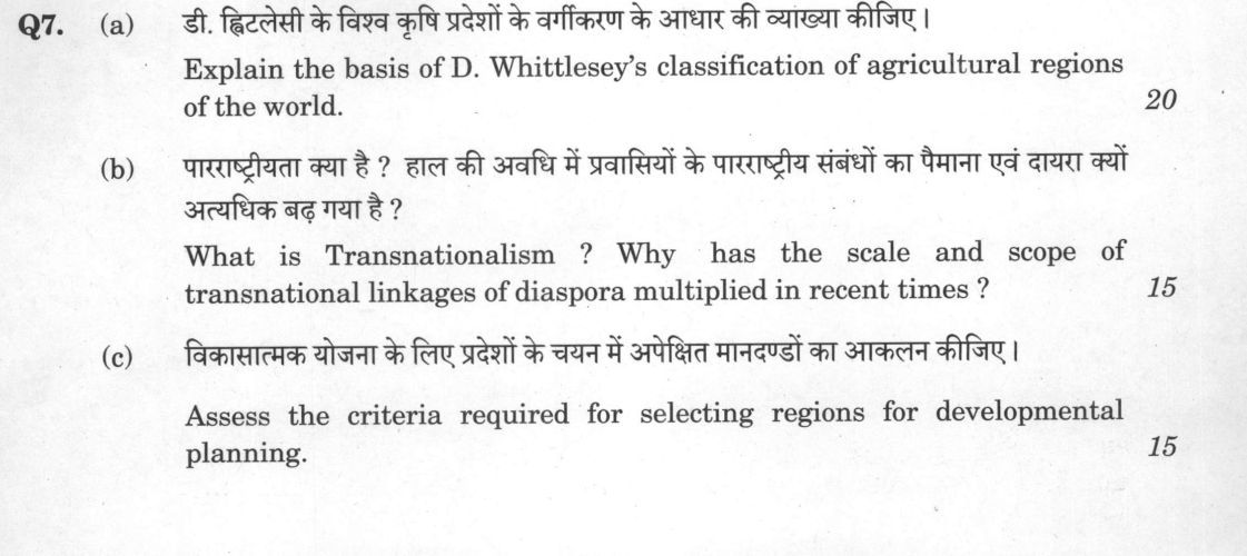
(a) Explain the basis of D. Whittlesey's classification of agricultural regions of the world. 20 (b) What is Transnationalism ?…
Explain the basis of D. Whittlesey's classification of agricultural regions of the world. 20 marks
What is Transnationalism ? Why has the scale and scope of transnational linkages of diaspora multiplied in recent times ? 15 marks
Assess the criteria required for selecting regions for developmental planning. 15 marks
हिंदी में प्रश्न पढ़ें
डी. हिटलेसी के विश्व कृषि प्रदेशों के वर्गीकरण के आधार की व्याख्या कीजिए। 20
पाराष्ट्रीयता क्या है ? हाल की अवधि में प्रवासियों के पाराष्ट्रीय संबंधों का पैमाना एवं दायरा क्यों अत्यधिक बढ़ गया है ? 15 marks
विकासात्मक योजना के लिए प्रदेशों के चयन में अपेक्षित मानदंडों का आकलन कीजिए। 15
Model answer
Written by UPSC Answer Check against this question's marking rubric, to the expected length. UPSC does not publish answers for Mains — this is one way to score well, not an official key.
These themes link production spaces, cross-border networks, and state planning.
(a) Whittlesey’s classification. D. Whittlesey’s world agricultural regions are based on recurring spatial patterns of farming rather than on crops alone. His standard five criteria are: the crop and livestock combination; the intensity of land use; the association of crops and livestock; the degree of commercialization; and the disposal of produce. In practice these are read with related characteristics of land tenure, power, and technology. These criteria capture how land is worked, how labour and capital are applied, how farm outputs are integrated, and whether produce is retained locally, sold in national markets, or exported. From these criteria Whittlesey identified thirteen world agricultural regions—Mediterranean, commercial grain, commercial livestock, mixed farming, plantation, shifting cultivation, pastoral, rice, commercial horticulture, commercial dairy, commercial fruit, commercial vegetables, and commercial poultry. The classification is useful because it shows that agriculture is a regional system: soil, climate, market access, transport, and farm size combine to produce distinctive landscapes.
The mechanism is clear: distant markets and high transport costs favour subsistence and local disposal; ports, railways, and cold chains expand commercialization and export disposal. Yet the scheme is static. It was built from early twentieth-century patterns and does not fully absorb technological diffusion—hybrid seeds, irrigation, mechanization, and digital market platforms—nor climate-change adaptation, such as heat-tolerant crops, altered sowing calendars, and water-stressed cropping. It also underplays policy shifts: subsidies, minimum support prices, land reforms, trade agreements, and food-security programmes can reconfigure regions faster than Whittlesey’s typology assumes.
(b) Transnationalism. Transnationalism refers to sustained cross-border social, economic, and political practices through which migrants maintain active ties with homelands while living abroad. It differs from assimilationist models that expect migrants to absorb into host societies and sever old attachments. Instead, transnationalism treats migration as a continuous network spanning borders.
The scale and scope of diaspora linkages have multiplied because digital connectivity has lowered the cost of communication, remittance transfers, and social participation. India’s annual remittance inflows exceed $125 billion, sustaining consumption, investment, and local development. Dual-citizenship policies in states such as France, Canada, and the UK have strengthened political and legal ties, while India, which does not permit dual citizenship, uses Overseas Citizen of India (OCI) status to provide long-term residency and economic rights. Transnational entrepreneurship links diaspora capital with home-country markets, startups, and supply chains. Home states also instrumentally engage diaspora for investment, soft power, and geopolitical support, making diaspora networks strategic assets.
(c) Regional planning criteria. Selecting regions for developmental planning requires criteria that identify where intervention will be effective and just. Resource endowment mapping identifies minerals, water, cropland, forests, and energy potential. Carrying capacity assessment tests whether population and economic activity can be sustained without ecological degradation. Existing infrastructure gradients reveal transport, power, communication, and market access gaps. Demographic pressures indicate population growth, migration, unemployment, and service needs. Environmental vulnerability indices highlight flood, drought, coastal, and climate risks. Institutional feasibility asks whether local administration, data, land records, and implementation capacity exist.
These criteria interact. A region may be resource-rich but institutionally weak, or infrastructure-rich but environmentally fragile. India’s agro-climatic regional planning uses rainfall, soil, cropping, and water resources to guide agriculture, while backward area development programmes target districts with low industrialization, poor infrastructure, and high poverty. The tension is between efficiency-oriented selection, which favours regions with high returns and ready markets, and equity-oriented selection, which prioritizes deprived, remote, or vulnerable areas. A defensible planning approach therefore balances growth potential with corrective justice, using criteria not as a checklist but as a diagnostic of where state action can alter trajectories. Together, these show that development geography must read production spaces, cross-border networks, and state interventions as interacting systems.
What "Explain" is asking you to do
Make the working of something clear — what sets it off, what follows from what, and what it produces. Explain is the Commission's mechanism word: it dominates the technical papers and the “explain why” stems, where the marks sit in the causal chain and not in the label.
Structure that answers it
State what it is → the initiating condition → the chain of cause, step by step → an instance where it plays out → what the chain produces
Where marks are lost
Describing what something looks like instead of why it works that way. Naming the stages without linking them reads as description too.
How this answer will be evaluated
Approach
Framework: Concept or mechanism > Diagram > Regional example > Application. (a) explain: definition/context > points in order > small example > short close | (b) explain: definition/context > points in order > small example > short close | (c) evaluate: criteria > evidence > balanced judgment Full marks: Precise definitions, clear causal chains, specific examples, and relevant diagrams/maps.
Key points expected
- Define agricultural region as a unit of specialization
- Identify Whittlesey's primary basis: crop combination and land use
- List secondary factors: climate, soil, market, technology
- Mention the 12 distinct agricultural regions identified
- Define transnationalism as maintaining multi-stranded social ties
- Identify 'push' factors: conflict, economic disparity, climate
- Identify 'pull' factors: labor demand, political stability
- Explain the role of ICT and reduced travel costs
Evaluation rubric
Each sub-part is marked on its own, against the marks and word limit printed on the paper.
- (a) Define Whittlesey's classification basis and list the specific factors used to delineate agricultural regions. 20 marks
explain— definition/context → points in order → small example → short close
Must cover
- Define agricultural region as a unit of specialization
- Identify Whittlesey's primary basis: crop combination and land use
- List secondary factors: climate, soil, market, technology
- Mention the 12 distinct agricultural regions identified
Loses marks
- Confusing Whittlesey with other classifications (e.g., Holdridge)
- Listing regions without explaining the basis of their formation
- Ignoring the role of market/technology in the classification
Earns more
- Reference to 'The Geographical Review' (1939)
- Distinction between subsistence and commercial regions
- Mention of 'mixed farming' as a key region type
- Note on the static nature of the classification
Extra mark
- Sketch map showing 3-4 major regions (e.g., Mediterranean, Commercial Grain)
- Reference to specific crops defining a region (e.g., wheat in Commercial Grain)
- (b) Define transnationalism and analyze the drivers behind the expansion of diaspora linkages. 15 marks
explain— definition/context → points in order → small example → short close
Must cover
- Define transnationalism as maintaining multi-stranded social ties
- Identify 'push' factors: conflict, economic disparity, climate
- Identify 'pull' factors: labor demand, political stability
- Explain the role of ICT and reduced travel costs
Loses marks
- Confusing transnationalism with simple migration
- Ignoring the 'scope' aspect (cultural, political, economic)
- Failing to link recent times to specific technological changes
Earns more
- Mention of 'transnationalism' vs 'internationalism'
- Reference to specific diaspora (e.g., Indian, Chinese, African)
- Discussion of 'brain drain' vs 'brain circulation'
- Mention of remittances as a key linkage
Extra mark
- Data on global remittance flows (World Bank)
- Example of a specific transnational organization (e.g., NRI associations)
- (c) Evaluate the specific criteria used to identify regions for developmental planning. 15 marks
evaluate— criteria → evidence → balanced judgment
Must cover
- Define 'developmental planning' in a regional context
- List economic criteria: GDP, per capita income, industrial base
- List social criteria: literacy, health, infrastructure
- Mention 'backwardness' or 'disadvantage' as a selection factor
Loses marks
- Listing criteria without assessing their relevance
- Ignoring the 'selection' aspect (why these regions?)
- Confusing 'development' with general 'growth'
Earns more
- Reference to 'Regional Planning' (e.g., Five Year Plans)
- Mention of 'convergence' as a goal of planning
- Distinction between 'planning region' and 'administrative unit'
- Reference to 'backward regions' (e.g., NE India, J&K)
Extra mark
- Example of a specific plan (e.g., NITI Aayog's Aspirational Districts)
- Mention of 'regional imbalances' as a rationale
Practice this exact question
Write your answer and it is marked point by point against the model answer above — what you covered, what you missed, what you got wrong.
Evaluate my answer →More from Geography 2024 Paper I
- Q4 (a) How is carbon neutrality essential for future environmental conservation ? Describe v…
- Q5 Answer the following in about 150 words each : 10×5=50 (a) Critically examine the signifi…
- Q6 (a) The urbanisation process is particularly pronounced in Asia and Africa, where too man…
- Q7 (a) Explain the basis of D. Whittlesey's classification of agricultural regions of the wo…
- Q8 (a) What is complementary region ? With reference to hierarchy of settlements, describe t…