Paper I — Q1
(a) What is 'Helical' flow ? How Helical flow accounts for meander modifications ? (10 marks) (b) Define 'pseudo monsoon' and…
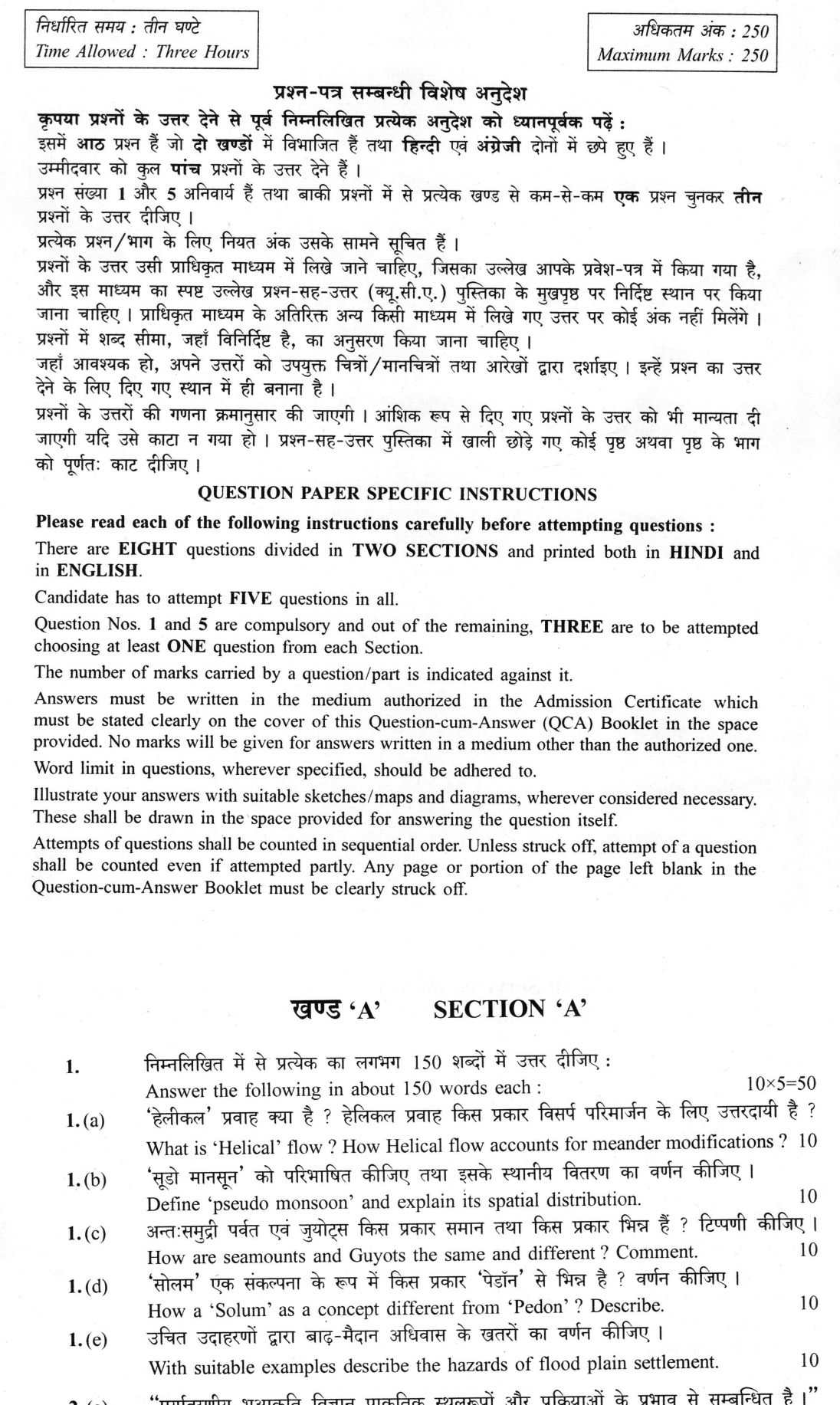
Answer the following in about 150 words each :
What is 'Helical' flow ? How Helical flow accounts for meander modifications ? 10 marks
Define 'pseudo monsoon' and explain its spatial distribution. 10 marks
How are seamounts and Guyots the same and different ? Comment. 10 marks
How a 'Solum' as a concept different from 'Pedon' ? Describe. 10 marks
With suitable examples describe the hazards of flood plain settlement. 10 marks
हिंदी में प्रश्न पढ़ें
निम्नलिखित में से प्रत्येक का लगभग 150 शब्दों में उत्तर दीजिए :
'हेलिकल' प्रवाह क्या है ? हेलिकल प्रवाह किस प्रकार विसर्प परिमार्जन के लिए उत्तरदायी है ? (10 अंक)
'सूडो मानसून' को परिभाषित कीजिए तथा इसके स्थानिक वितरण का वर्णन कीजिए । (10 अंक)
अन्त:समुद्री पर्वत एवं जुयोट्स किस प्रकार समान तथा किस प्रकार भिन्न हैं ? टिप्पणी कीजिए । (10 अंक)
'सोलम' एक संकल्पना के रूप में किस प्रकार 'पेडॉन' से भिन्न है ? वर्णन कीजिए । (10 अंक)
उचित उदाहरणों द्वारा बाढ़-मैदान अधिवास के खतरों का वर्णन कीजिए । (10 अंक)
Model answer
Drafted with AI by UPSC Answer Check against this question's marking rubric, to the 150-word length. UPSC does not publish answers for Mains — this is one way to score well, not an official key. How we build rubrics and answers.
(a) Helical flow and meander modification
Helical flow, or helicoidal flow, is a secondary circulation pattern in alluvial channel bends where surface water is driven toward the concave (outer) bank by centrifugal force and super-elevation, while return flow moves along the bed toward the convex (inner) bank. First described by James Thomson (1876) and later elaborated by Einstein (1926), this corkscrew motion is fundamental to meander dynamics.
This flow mechanics directly accounts for meander modifications. High-velocity surface flow erodes the cut-bank, while low-velocity bed flow deposits sediment on the convex bank, building a point bar, and the thalweg shifts toward the outer bank. This process of lateral accretion causes the meander to migrate laterally and sweep downstream. The flow also creates a pool–riffle sequence, with deep pools at the outer bends and shallow riffles at the crossover (inflection) reaches between bends. As the meander amplitude grows, the neck between two bends narrows, eventually leading to a neck cut-off and the formation of an oxbow lake. Leopold and Wolman quantified these dynamics, noting that meander wavelength is typically 10–14 times the channel width.
(b) Pseudo monsoon
A pseudo monsoon is a monsoon-like seasonal wind and rainfall rhythm that fails the criteria of Ramage (1971). His true monsoon realm (25°S–35°N, 30°W–170°E) requires a January–July shift of prevailing surface wind of at least 120°, a prevailing-wind frequency above 40% in both months, a mean resultant wind above 3 m/s in at least one of them, and fewer than one cyclone–anticyclone alternation every two years. In textbook usage the term also denotes a regime where only one phase — usually the summer inflow drawn in by a thermal low as the ITCZ migrates poleward — is well developed.
Pseudo monsoons lie outside Ramage's box, with shallow circulation, incomplete upper-air reversal and weak, erratic rain. The chief example is the North American monsoon over the Sonoran Desert and the south-western United States, where a summer thermal low draws moisture from the Gulfs of California and Mexico. Another is the South American monsoon over the Amazon basin and the Brazilian Planalto. Unlike the South Asian monsoon, these systems lack an elevated Tibetan-type heat source, the Tropical Easterly Jet and the Somali (Findlater) low-level jet.
(c) Seamounts and guyots
Seamounts and guyots are both submarine volcanic peaks with a relief of at least 1,000 m, typically found in intraplate settings or along mid-ocean ridges. They share a common origin and composition, representing stages in the evolution of oceanic volcanism.
The primary difference lies in their summit morphology and history. A seamount retains a pointed or conical summit, indicating it has never been exposed to wave action. A guyot, a term coined by Harry Hammond Hess (1946) after the geographer Arnold Henry Guyot, is a flat-topped seamount. This flat top is the result of subaerial wave planation when the volcano was at sea level, followed by thermal subsidence of the cooling lithosphere.
This distinction is evidentially significant. The age- and depth-progression of guyots, such as those in the Hawaiian–Emperor chain or the Mid-Pacific Mountains, provides strong support for seafloor spreading and plate subsidence. This process parallels Charles Darwin’s subsidence theory of atolls, where a fringing reef evolves into a barrier reef and then an atoll as the volcanic base sinks.
(d) Solum and pedon
The concepts of 'solum' and 'pedon' are distinct in soil science, differing in dimensionality, boundaries, and purpose. The solum is a two-dimensional genetic section of the soil, comprising the A, E, and B horizons. It excludes the C horizon (parent material) and R horizon (bedrock), focusing specifically on the zone of active soil formation and biological activity.
In contrast, a pedon is the smallest three-dimensional sampling body of soil used in the USDA Soil Taxonomy. It is a volume of soil, typically 1 to 10 square metres in area, that extends down to the lower limit of the soil, usually taking in part of the C horizon, so that it normally contains the whole solum. While the solum is used to describe soil genesis and the processes of horizon formation, the pedon is the fundamental unit for soil survey and classification. A group of contiguous, similar pedons forms a polypedon, which is the basis for a soil series. Thus, the solum is a conceptual section for understanding soil development, whereas the pedon is a practical, volumetric unit for mapping and classification.
(e) Hazards of flood-plain settlement
Settlement on river flood plains exposes people to physical and induced hazards. Inundation is the commonest: in the Mumbai floods of 26 July 2005, about 944 mm of rain fell at Santacruz in a day and the encroached Mithi river overflowed. Encroachment on the Yamuna flood plain in Delhi was exposed when the river reached a record 208.66 m in July 2023. Bank erosion is severe in the Brahmaputra valley, where Majuli island in Assam is shrinking.
Avulsion, a sudden change of course, is catastrophic: the Kosi, the 'Sorrow of Bihar', avulsed at Kusaha in 2008. The levee effect adds risk, since confining rivers raises flood stages and makes breaches more severe; Gilbert F. White's Human Adjustment to Floods (1945) showed that structural protection alone invites further occupation, which is why India's Model Flood Plain Zoning Bill (1975) and the Rashtriya Barh Ayog (1980) stressed zoning. Saturated alluvium is also prone to liquefaction during earthquakes, as in the 2001 Bhuj earthquake. Epidemics and displacement compound these physical hazards.
How this answer will be evaluated
Evaluation rubric
Each sub-part is marked on its own, against the marks and word limit printed on the paper.
- (a) Two linked demands: (i) define helical (helicoidal/corkscrew) flow in an alluvial channel bend, and (ii) explain HOW this secondary circulation modifies meanders — i.e. link the flow mechanics to bank erosion, point-bar deposition, lateral migration, downstream sweep and cut-off. A definition alone cannot score above half marks; the 'how' of meander modification must be explicit. 10 marks · 150 words
Must cover
- Helicoidal / corkscrew flow
- Super-elevation and centrifugal force
- Concave (outer, cut) bank versus convex (inner) bank
- Point bar and lateral accretion
- Thalweg
- Pool and riffle
- Neck cut-off / oxbow lake
- James Thomson (1876); Einstein (1926); Leopold and Wolman (meander wavelength about 10–14 channel widths)
Loses marks
- Defining helical flow only as 'spiral flow of water' without the super-elevation–pressure-gradient mechanism that creates it
- Reversing the circulation — saying surface water moves toward the inner bank and bed flow toward the outer bank
- Attributing meander erosion purely to centrifugal force or to Coriolis force, ignoring the secondary cell
- Stopping at the definition and never answering the second half (how meanders are modified)
- Confusing point bars with levees or with braid bars; calling an oxbow a meander scar without distinguishing cut-off types
Earns more
- Consequent meander modification: lateral migration, amplitude growth, downstream sweep, neck/chute cut-off and oxbow lake formation; pool–riffle sequence
- Attribution and/or quantification: James Thomson (1876) on secondary circulation in bends, Einstein (1926) 'tea-leaf' analogy; Leopold and Wolman — meander wavelength about 10–14 times channel width, radius of curvature about 2–3 widths
- (b) Two demands: define 'pseudo monsoon' (a monsoon-like seasonal rhythm that fails the strict criteria of a true monsoon — anchored either in Ramage's criteria or in the textbook sense of a regime where only one monsoonal phase, usually the summer inflow, is well developed) and then map its spatial distribution, naming the regions concerned. The definition must be anchored in an accepted criterion set rather than asserted loosely. 10 marks · 150 words
Must cover
- Ramage (1971), Monsoon Meteorology — the four criteria and the 25 S–35 N, 30 W–170 E monsoon box
- Inter-Tropical Convergence Zone (ITCZ) migration
- North American (south-west USA/Sonoran) monsoon
- South American monsoon system (Amazon–Brazilian Planalto)
- Contrast with the true South Asian monsoon: Tibetan Plateau heat source, Tropical Easterly Jet, Somali (Findlater) low-level jet
Loses marks
- Treating 'pseudo monsoon' as a synonym for 'break monsoon', 'false onset' or 'bogus monsoon rain' over India — it is a regional-climatological category, not an Indian sub-seasonal event
- Describing the Indian monsoon at length instead of the pseudo-monsoon regions actually asked about
- Giving a definition with no named regions, so the 'spatial distribution' half is unanswered
- Asserting a single authoritative definition when the term is not fully standardised, instead of anchoring it in Ramage's criteria or the one-phase textbook sense
- Confusing the pseudo monsoon with the Mediterranean winter-rain regime or with trade-wind coastal rainfall
Earns more
- Identifies the true monsoon realm (roughly 25 degrees S–35 degrees N, 30 degrees W–170 degrees E: South, Southeast and East Asia, West Africa, northern Australia) so that the pseudo-monsoon belt can be located relative to it
- Explains why they remain 'pseudo': shallow circulation, no elevated Tibetan-type heat source, no Tropical Easterly Jet, incomplete upper-air reversal, and hence weak and erratic rainfall
- (c) A two-sided comparison: state how seamounts and guyots are alike (origin, composition, setting, relief, plate-tectonic context) and how they differ (summit morphology, history of emergence and wave planation, summit depth, evidential value). 'Comment' requires a short evaluative close, not a bare list. 10 marks · 150 words
Must cover
- Harry Hammond Hess (1946) — discovery and naming of guyots
- Arnold Henry Guyot — the geographer after whom they are named
- Threshold relief of 1,000 m for a seamount
- Wave planation / abrasion platform plus thermal subsidence of cooling lithosphere
- Charles Darwin's subsidence theory of atolls
- Hawaiian–Emperor seamount chain; Great Meteor Seamount; Mid-Pacific Mountains guyots
Loses marks
- Treating them as unrelated features rather than stages of one evolutionary sequence
- Attributing the flat top to submarine erosion or to deposition, instead of subaerial/wave-base planation of a former island followed by subsidence
- Confusing guyots with oceanic plateaus, abyssal hills, atolls or submarine ridges
- Answering only the 'different' half and omitting genuine similarities, or vice versa
- Mis-attributing the discovery (to Murray, Agassiz or Wegener) or mis-spelling the eponym
Earns more
- Evidential significance: age- and depth-progression of guyots supports seafloor spreading and plate subsidence, and parallels Darwin's subsidence theory of coral atolls (fringing reef–barrier reef–atoll)
- Attribution and examples: Harry H. Hess (1946), guyot named after Arnold H. Guyot; examples such as the Hawaiian–Emperor chain, Koko/Detroit Guyot, Great Meteor Seamount, Mid-Pacific Mountains
- (d) Define both concepts precisely and then contrast them on dimensionality, boundaries, depth limits and purpose: solum is a two-dimensional genetic section (A + E + B horizons), pedon is the smallest three-dimensional sampling body of soil in Soil Taxonomy. The word 'describe' requires explanation of why each concept was needed, not just a definition pair. 10 marks · 150 words
Must cover
- Solum = A + E + B horizons; excludes C and R
- Pedon — USDA Soil Taxonomy (Soil Survey Staff); roughly hexagonal, 1 to 10 square metres
- Polypedon = soil individual / basis of the soil series
- Soil profile and horizon nomenclature (O, A, E, B, C, R)
- Hans Jenny's clorpt factors (climate, organisms, relief, parent material, time) after V. V. Dokuchaev
Loses marks
- Equating solum with the whole soil profile, i.e. wrongly including the C horizon or bedrock
- Describing the pedon as merely a 'soil profile' or a two-dimensional section, losing its three-dimensional, volume-based character
- Omitting the size convention of the pedon (1 to 10 square metres) so the concept remains vague
- Confusing pedon with polypedon, or with the soil series/soil association
- Listing the two definitions without ever making the comparison the question demands
Earns more
- Contrast on depth and inclusion: the pedon extends to the lower limit of the soil (usually into the C horizon) and therefore normally contains the solum; and contrast on purpose (soil genesis versus soil survey and classification)
- Mentions polypedon (contiguous similar pedons = the soil individual/soil series mapping unit) and/or the Jenny–Dokuchaev soil-forming-factor context
- (e) Describe the hazards that arise when settlements occupy river flood plains, and illustrate each with named, real examples. 'With suitable examples' is a scoring condition, not decoration: unexemplified hazard lists cannot reach full marks. Both physical hazards (inundation, bank erosion, avulsion, liquefaction) and induced/social hazards (levee effect, encroachment, epidemics, displacement) are expected. 10 marks · 150 words
Must cover
- Kosi 2008 avulsion at Kusaha; 'Sorrow of Bihar'
- Mumbai floods, 26 July 2005 (Mithi river, about 944 mm)
- Yamuna flood plain encroachment, Delhi (2023 record stage 208.66 m)
- Majuli / Brahmaputra bank erosion
- Gilbert F. White, 'Human Adjustment to Floods' (1945); Burton, Kates and White, 'The Environment as Hazard' (1978); the levee effect
- Flood-plain zoning — Model Flood Plain Zoning Bill, 1975; Rashtriya Barh Ayog (National Flood Commission), 1980
Loses marks
- Writing a general essay on floods and their causes instead of the hazards specific to settling ON a flood plain
- Giving no named example, or naming only 'Bihar floods' without river, year or mechanism
- Omitting non-inundation hazards — avulsion, bank erosion, liquefaction, waterlogging, disease
- Treating embankments as an unqualified solution, missing the levee effect and the residual-risk argument
- Devoting the whole note to remedies and neglecting the 'hazards' the question asks for
Earns more
- Geotechnical and health hazards: seismic amplification and liquefaction on saturated alluvium (Mexico City 1985; Bhuj 2001), waterlogging and salinity, and water-borne epidemics
- The 'levee effect' / safe-development paradox and the non-structural remedy — flood-plain zoning; Gilbert F. White (1945), Burton, Kates and White (1978); India's Model Flood Plain Zoning Bill 1975 and Rashtriya Barh Ayog 1980
What "Explain" is asking you to do
Make the working of something clear — what sets it off, what follows from what, and what it produces. Explain is the Commission's mechanism word: it dominates the technical papers and the “explain why” stems, where the marks sit in the causal chain and not in the label.
Structure that answers it
State what it is → the initiating condition → the chain of cause, step by step → an instance where it plays out → what the chain produces
Where marks are lost
Describing what something looks like instead of why it works that way. Naming the stages without linking them reads as description too.
Practice this exact question
Write your answer and it is marked point by point against the model answer above — what you covered, what you missed, what you got wrong.
Evaluate my answer →More from Geography 2026 Paper I
- Q1 Answer the following in about 150 words each : (a) What is 'Helical' flow ? How Helical f…
- Q2 (a) "Environmental geomorphology deals with the impact of natural landforms and processes…
- Q3 (a) Describe the general characteristics and structure of a thunderstorm and suggest suit…
- Q4 (a) How does the annual variations in temperature and precipitation influence plants grow…