Paper I — Q3
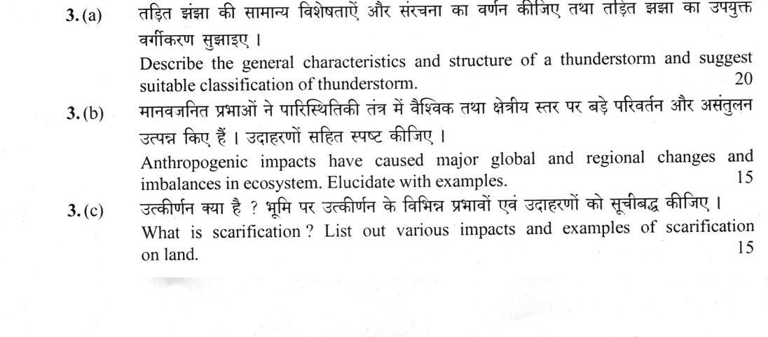
(a) Describe the general characteristics and structure of a thunderstorm and suggest suitable classification of thunderstorm. (20…
Describe the general characteristics and structure of a thunderstorm and suggest suitable classification of thunderstorm. 20 marks
Anthropogenic impacts have caused major global and regional changes and imbalances in ecosystem. Elucidate with examples. 15 marks
What is scarification ? List out various impacts and examples of scarification on land. 15 marks
हिंदी में प्रश्न पढ़ें
तड़ित झंझा की सामान्य विशेषताएँ और संरचना का वर्णन कीजिए तथा तड़ित झंझा का उपयुक्त वर्गीकरण सुझाइए । (20 अंक)
मानवजनित प्रभावों ने पारिस्थितिकी तंत्र में वैश्विक तथा क्षेत्रीय स्तर पर बड़े परिवर्तन और असंतुलन उत्पन्न किए हैं । उदाहरणों सहित स्पष्ट कीजिए । (15 अंक)
उत्कीर्णन क्या है ? भूमि पर उत्कीर्णन के विभिन्न प्रभावों एवं उदाहरणों को सूचीबद्ध कीजिए । (15 अंक)
Model answer
Drafted with AI by UPSC Answer Check against this question's marking rubric, to the expected length. UPSC does not publish answers for Mains — this is one way to score well, not an official key. How we build rubrics and answers.
(a) Thunderstorms: characteristics, structure and classification
A thunderstorm is a convective weather system characterized by the rapid vertical transport of air, driven by conditional instability. Its formation requires three essential ingredients: a warm, moist lower atmosphere, conditional instability (high CAPE), and a lifting mechanism to initiate ascent. It is produced by a cumulonimbus cloud whose top commonly reaches 12–18 km; a single cell is typically about 10 km across, lives for 30–60 minutes, and brings lightning and thunder, heavy showers, hail, squalls and downbursts. Structurally, the classic thunderstorm cell follows the three-stage model proposed by Byers and Braham (1949). The cumulus stage is defined by a strong updraft and the development of a towering cumulus cloud. The mature stage is marked by the coexistence of updrafts and downdrafts; the updraft reaches the tropopause to form a spreading anvil (cirrus) and an overshooting top, while precipitation falls through the updraft, creating a downdraft. The dissipating stage occurs as the downdraft dominates, cutting off the supply of moist air and causing the storm to decay. A critical feature of the mature stage is the gust front, a leading edge of cool outflow air that can trigger new cells.
A suitable classification of thunderstorms is based on the degree of vertical wind shear, which determines storm organization and longevity.
- Single-cell storms: Occur in low-shear environments; they are short-lived and follow the three-stage cycle.
- Multicell clusters: Occur in moderate shear; new cells form along the gust front of dying cells, creating a cluster.
- Squall lines: Organized multicell systems that form a linear band, often associated with cold fronts.
- Supercells: Occur in high-shear environments; they feature a rotating updraft (mesocyclone), identified by Browning (1962), and are the primary source of large hail and tornadoes.
A second, genetic classification keys storms to their trigger: thermal (convectional/air-mass) storms of summer afternoons, orographic storms on windward slopes, frontal storms along cold fronts, and nocturnal storms over plains and water bodies. Large organised systems form mesoscale convective systems, the largest being mesoscale convective complexes (Maddox, 1980).
In the Indian context, the Nor'wester (Kal Baisakhi) of Bengal and the Bardoli Chheerha of Assam are classic examples of intense pre-monsoon thunderstorms, alongside the mango showers of Kerala and Karnataka and the dusty Andhi of north-west India.
(b) Anthropogenic ecosystem change and imbalance
Anthropogenic impacts have fundamentally altered the Earth's biosphere, leading to systemic changes and imbalances at both global and regional scales. At the global scale, the "Anthropocene" (Crutzen and Stoermer, 2000) is defined by human domination of biogeochemical cycles. Vitousek et al. (1997) showed that humans have transformed one-third to one-half of the land surface and use more than half of accessible surface fresh water. Key indicators of global change include the rise in atmospheric CO₂ from 280 ppm to over 420 ppm, warming of about 1.1 °C by 2011–2020 (IPCC AR6), with 2024 the first calendar year about 1.55 °C above pre-industrial (WMO), and the doubling of reactive nitrogen flux due to the Haber-Bosch process. The Planetary Health Check 2025 found seven of the nine "planetary boundaries" (Rockström et al., 2009) transgressed, ocean acidification among them (surface pH down by about 0.1 unit). Building on the Millennium Ecosystem Assessment (2005), the IPBES Global Assessment (2019) estimates that about one million species face extinction.
At the regional scale, these global drivers manifest as specific ecosystem imbalances. The Aral Sea has shrunk by over 90% due to irrigation diversions, leading to a total collapse of its fishery. Lake Chad has lost about 90% of its 1960s area through drought and water abstraction, undermining fisheries and pastoral livelihoods. In the Gulf of Mexico, nutrient runoff has created a massive hypoxic "dead zone." The Great Barrier Reef is experiencing mass bleaching due to thermal stress, while the Amazon is approaching a tipping point where deforestation may trigger a transition from rainforest to savanna. In the Sundarbans, sea-level rise and salinity intrusion are disrupting the mangrove ecosystem. These examples illustrate that human activity has moved from local land-use change to a global force that disrupts the stability of terrestrial and marine ecosystems. Responses such as the Montreal Protocol (1987), under which the ozone layer is recovering, and the Kunming–Montreal Global Biodiversity Framework (2022) with its 30x30 target show that such imbalances can be corrected.
(c) Scarification
Scarification is a direct, excavational anthropogeomorphic process where human activity physically removes or displaces the earth's surface, creating a permanent "scar" on the landscape. In the context of anthropogeomorphology (Golomb and Eder, 1964), it refers to the mechanical alteration of landforms through mining, quarrying, and earth-moving. Andrew Goudie classes it among the direct human geomorphic processes, and Roger LeB. Hooke (1994, 2000) showed that human earth-moving now rivals or exceeds the sediment moved by all the world's rivers.
Impacts of Scarification on Land:
- Topographic Modification: Creation of highwalls, deep pits, and artificial ridges (spoil/overburden dumps).
- Subsidence: Ground collapse due to underground mining or the removal of support structures.
- Hydrological Derangement: Disruption of natural drainage patterns, leading to channel incision or the formation of acid mine drainage (AMD).
- Soil Degradation: Removal of the fertile topsoil layer and the exposure of sterile substrates.
Examples of Scarification:
- Jharia Coalfield (India): Characterized by massive subsidence and a persistent, self-sustaining mine fire.
- Singrauli and Korba (India): Extensive opencast mining has created vast, landscape-altering pits.
- Bailadila (India): Iron ore mining has resulted in significant topographic modification and spoil heap accumulation.
- Aravalli Range (India): Intensive stone quarrying has led to the "sculpting" of hills and the creation of deep, irregular pits.
- Bingham Canyon (USA): One of the largest man-made excavations in the world, a massive open-pit copper mine.
- Mir mine (Russia) and Athabasca oil sands (Canada): A giant diamond pit and vast surface-mined tar-sand landscapes.
- Yamuna and Sone Rivers (India): Sand mining has caused severe channel incision and bank instability.
To mitigate these impacts, regulatory frameworks such as the MMDR Amendment Act 2015 (establishing the District Mineral Foundation) the EIA Notification 2006 and the Sustainable Sand Mining Management Guidelines 2016 mandate progressive reclamation, backfilling, and the restoration of topsoil.
How this answer will be evaluated
Evaluation rubric
Each sub-part is marked on its own, against the marks and word limit printed on the paper.
- (a) Three connected tasks: 'describe the general characteristics' of a thunderstorm (conditions of formation, dimensions, energetics, associated weather), 'describe its structure' (the three-stage cell model with updraft, downdraft, anvil and gust front), and 'suggest a suitable classification' -- that is, propose and justify a scheme, ideally both by organisation/vertical shear and by triggering mechanism. Omitting the classification, or offering it without justification, is a major loss. 20 marks
Must cover
- Conditional instability, low-level moisture, lifting trigger, CAPE
- Byers and Braham, Thunderstorm Project (1949) -- cumulus, mature and dissipating stages
- Anvil (cirrus), overshooting top, gust front / outflow boundary, downburst
- Vertical wind shear as the control on storm organisation
- Single-cell, multicell cluster, squall line, supercell (Browning, 1962; mesocyclone, wall cloud, hook echo), MCS/MCC (Maddox, 1980)
- Nor'wester / Kal Baisakhi; Bardoli Chheerha; mango showers; Andhi
Loses marks
- Answering only 'characteristics and structure' and never suggesting a classification, which is a third of the question
- Offering a classification with no organising principle -- a bare list of names -- instead of keying it to vertical wind shear or to the triggering mechanism
- Confusing a thunderstorm with a tropical cyclone: quoting cyclone diameters, eye, warm core or Saffir-Simpson scale
- Describing the three stages in the wrong order, or placing the downdraft in the cumulus stage and the gust front in the dissipating stage
- Giving no Indian example in a paper that rewards regional grounding, or misplacing Kal Baisakhi in the monsoon season instead of the pre-monsoon
Earns more
- Adds a second classificatory axis by triggering mechanism -- thermal/convectional, orographic, frontal, air-mass and nocturnal -- and states a severity criterion (damaging hail, winds of about 90 km/h or more, or a tornado)
- Grounds the answer in named regional examples: Nor'wester/Kal Baisakhi of Bengal, Bardoli Chheerha of Assam, mango showers, Andhi of north-west India, lightning mortality and IMD radar-based nowcasting
- (b) 'Elucidate with examples' a statement that has two explicit scales -- global AND regional -- and two explicit outcomes: major changes and imbalances in ecosystems. The answer must therefore be organised by scale, must show change (altered structure, composition, flux) as distinct from imbalance (loss of stability, tipping, disrupted cycles), and must name real cases for each. 15 marks
Must cover
- Anthropocene -- Paul Crutzen and Eugene Stoermer (2000)
- Vitousek et al. (1997), 'Human Domination of Earth's Ecosystems'
- Planetary boundaries -- Rockstrom et al. (2009), with the Planetary Health Check 2025 finding seven of nine transgressed; Millennium Ecosystem Assessment (2005); IPBES Global Assessment (2019)
- CO2 about 280 ppm pre-industrial to above 420 ppm; warming of about 1.1 degrees C for 2011-2020 (IPCC AR6), with 2024 about 1.55 degrees C above pre-industrial (WMO)
- Haber-Bosch and the doubling of the reactive nitrogen flux; ocean acidification of about 0.1 pH unit
- Named regional cases: Aral Sea, Lake Chad, Gulf of Mexico dead zone, Great Barrier Reef, Amazon, Sundarbans
- Montreal Protocol (1987); Kunming-Montreal Global Biodiversity Framework (2022)
Loses marks
- Writing a general 'pollution and global warming' essay that never separates the global from the regional scale, although the statement names both
- Listing impacts without any named place, date or figure, so nothing is checkable
- Treating 'change' and 'imbalance' as synonyms and so missing the ecosystem-dynamics content (cascades, thresholds, tipping points)
- Quoting invented statistics -- a wrong CO2 concentration, a wrong warming figure, or a species-extinction number attributed to the wrong report
- Attributing the 'one million species' estimate to the IPCC rather than to IPBES (2019), or the planetary boundaries to the IPCC rather than to Rockstrom and colleagues
Earns more
- Distinguishes imbalance from mere change by naming mechanisms: trophic cascade, eutrophication and hypoxia, biotic invasion and homogenisation, fragmentation and edge effects, altered fire/hydrological regimes, zoonotic spillover, and non-linear tipping points
- Closes with the policy and equity dimension: Montreal Protocol's success against the Kyoto-Paris shortfall, the Kunming-Montreal Global Biodiversity Framework (2022) and 30x30, UN Decade on Ecosystem Restoration, and the unequal distribution of impact
- (c) Two explicit tasks: define scarification, and then 'list out' both its impacts on land and examples of it. Because the verb is 'list out', a well-organised classified list -- forms, impacts and named cases -- is rewarded over a flowing essay; but the definition must come first and must be the geomorphological one, since the question asks about impacts 'on land'. 15 marks
Must cover
- Scarification as a direct, excavational anthropogeomorphic process
- Anthropogeomorphology -- commonly credited to Golomb and Eder (1964); Andrew Goudie's classification of direct human geomorphic processes
- Roger LeB. Hooke (1994, 2000) on humans as the premier geomorphic agent, human earth-moving comparable to or exceeding total river sediment transport
- Spoil/overburden dumps, highwalls, subsidence, acid mine drainage, derelict land
- Named cases: Jharia mine fire and subsidence, Singrauli/Korba opencast, Bailadila, Aravalli quarrying, Yamuna and Sone sand mining, Bingham Canyon (Utah), Mir mine, Athabasca oil sands
- MMDR Amendment Act 2015 and the District Mineral Foundation; EIA Notification 2006; Sustainable Sand Mining Management Guidelines (2016)
Loses marks
- Answering the wrong sense of the word -- writing about seed scarification in germination or soil scarification in silviculture -- when the question asks for impacts 'on land' and belongs to the anthropogeomorphology section of the syllabus
- Defining scarification and then stopping, without the 'list out' of impacts and examples the question demands
- Giving unnamed examples ('mining areas of eastern India') where named coalfields, quarries and rivers are expected
- Confusing scarification with indirect human impacts such as accelerated soil erosion or subsidence from groundwater withdrawal -- these are worth mentioning as contrasts but are not scarification itself
- Omitting the hydrological consequences (drainage derangement, channel incision from sand mining, acid mine drainage), which are the impacts most often examined
Earns more
- Supplies at least four named examples, Indian and foreign -- e.g. Jharia (mine fire and subsidence), Raniganj, Singrauli or Korba, Bailadila, Goa iron ore, Aravalli quarrying, Yamuna or Sone sand mining, Bingham Canyon, Mir mine, Athabasca oil sands, Suez or Panama canal
- Notes remedies and the regulatory frame: mine closure and progressive reclamation, backfilling, benching and afforestation of spoil, topsoil conservation, EIA Notification 2006, MMDR Amendment 2015 and the District Mineral Foundation, Sustainable Sand Mining Management Guidelines (2016)
What "Describe" is asking you to do
Give a full, ordered account of the thing named — its parts, stages or mechanism — in the sequence in which it actually exists or occurs. Most describe questions come from the science optionals, where the marks sit in correct technical detail and, where the stem says so, a labelled diagram.
Structure that answers it
One-line identification of the subject → the parts or stages in their real order, each with its defining detail → labelled diagram where the subject is structural → closing line on function or significance
Where marks are lost
Loose general prose where the examiner is ticking named parts, correct terminology and their sequence; and in the General Studies papers, turning to evaluation before the description is finished.
Practice this exact question
Write your answer and it is marked point by point against the model answer above — what you covered, what you missed, what you got wrong.
Evaluate my answer →More from Geography 2026 Paper I
- Q1 Answer the following in about 150 words each : (a) What is 'Helical' flow ? How Helical f…
- Q2 (a) "Environmental geomorphology deals with the impact of natural landforms and processes…
- Q3 (a) Describe the general characteristics and structure of a thunderstorm and suggest suit…
- Q4 (a) How does the annual variations in temperature and precipitation influence plants grow…
- Q5 Answer the following in about 150 words each : (a) “Systematic Geography is essentially a…
- Q6 (a) Discuss the Geometry of Land Values in Urban Community and delimiting the Central Bus…