Paper II — Q1
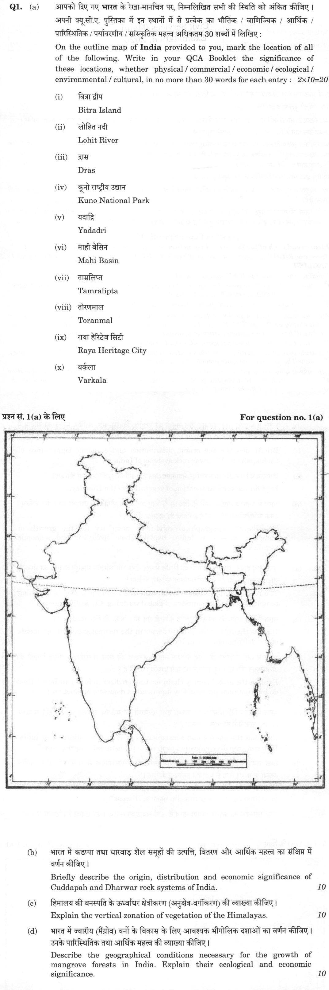
(a) On the outline map of India provided to you, mark the location of all of the following. Write in your QCA Booklet the…
On the outline map of India provided to you, mark the location of all of the following. Write in your QCA Booklet the significance of these locations, whether physical / commercial / economic / ecological / environmental / cultural, in no more than 30 words for each entry : 2×10=20 Bitra Island
Lohit River
Dras
Kuno National Park
Yadadri
Mahi Basin
Tamralipta
Toranmal
Raya Heritage City
Varkala For question no. 1(a) 20 marks
Briefly describe the origin, distribution and economic significance of Cuddapah and Dharwar rock systems of India. 10 marks
Explain the vertical zonation of vegetation of the Himalayas. 10 marks
Describe the geographical conditions necessary for the growth of mangrove forests in India. Explain their ecological and economic significance. 10 marks
हिंदी में प्रश्न पढ़ें
आपको दिए गए भारत के रेखा-मानचित्र पर, निम्नलिखित सभी की स्थिति को अंकित कीजिए । अपनी क्यू.सी.ए. पुस्तिका में इन स्थानों में से प्रत्येक का भौतिक / वाणिज्यिक / आर्थिक / पारिस्थितिक / पर्यावरणीय / सांस्कृतिक महत्व अधिकतम 30 शब्दों में लिखिए : बित्रा द्वीप
लोहित नदी
द्रास
कूनो राष्ट्रीय उद्यान
यदाद्रि
माही बेसिन
ताम्रलिप्त
तोरणमाल
राया हेरिटेज सिटी
वर्कला प्रश्न सं. 1(a) के लिए (20 अंक)
भारत में कडप्पा तथा धारवाड़ शैल समूहों की उत्पत्ति, वितरण और आर्थिक महत्व का संक्षेप में वर्णन कीजिए। (10 अंक)
हिमालय की वनस्पति के ऊर्ध्वाधर क्षेत्रीकरण (अनुक्षेत्र-वर्गीकरण) की व्याख्या कीजिए। (10 अंक)
भारत में ज्वारीय (मैंग्रोव) वनों के विकास के लिए आवश्यक भौगोलिक दशाओं का वर्णन कीजिए। उनके पारिस्थितिक तथा आर्थिक महत्व की व्याख्या कीजिए। (10 अंक)
Model answer
Drafted with AI by UPSC Answer Check against this question's marking rubric, to the expected length. UPSC does not publish answers for Mains — this is one way to score well, not an official key. How we build rubrics and answers.
(a) Map Locations and Significance
(i) Bitra Island Location: Lakshadweep Sea, Arabian Sea. Significance: Smallest inhabited island of Lakshadweep, a coral island on a broad lagoon reef; in July 2025 the administration proposed acquiring it for defence use because of its strategic location.
(ii) Lohit River Location: Eastern Arunachal Pradesh. Significance: Enters India from Tibet near Kibithu and joins the Siang and Dibang near Sadiya to form the Brahmaputra; Parshuram Kund pilgrimage; crossed by the Bhupen Hazarika (Dhola–Sadiya) Setu.
(iii) Dras Location: Kargil district, Ladakh. Significance: The "Gateway to Ladakh" below Zoji La on the Srinagar–Leh highway (NH 1), one of the coldest inhabited places in the world, and site of the Kargil War Memorial (1999).
(iv) Kuno National Park Location: Sheopur district, Madhya Pradesh. Significance: Site of Project Cheetah: cheetahs from Namibia (September 2022) and South Africa (February 2023) were reintroduced here, the first intercontinental translocation of a large carnivore.
(v) Yadadri Location: Yadadri Bhuvanagiri district, Telangana. Significance: Temple town of the Lakshmi Narasimha Swamy shrine, rebuilt in stone and reopened in 2022; a major Deccan pilgrimage centre whose older name, Yadagirigutta, the state restored in 2024.
(vi) Mahi Basin Location: Western Madhya Pradesh, southern Rajasthan and eastern Gujarat. Significance: The Mahi rises in the Vindhyas and crosses the Tropic of Cancer twice before entering the Gulf of Khambhat; the Mahi Bajaj Sagar and Kadana dams support irrigation and hydropower.
(vii) Tamralipta Location: Tamluk, West Bengal. Significance: An ancient port on the Rupnarayan River. It was a vital commercial hub for trade with Southeast Asia and the Mediterranean in antiquity.
(viii) Toranmal Location: Nandurbar district, Maharashtra. Significance: Plateau hill station in the western Satpura range with Yashwant Lake and the Gorakhnath temple fair; its forests sustain a Bhil and Pawara tribal landscape.
(ix) Raya Heritage City Location: Mathura district, Uttar Pradesh. Significance: A heritage city planned by YEIDA near Raya on the Yamuna Expressway, themed on Braj and Krishna heritage, to promote religious tourism and ease pressure on Mathura–Vrindavan.
(x) Varkala Location: Thiruvananthapuram district, Kerala. Significance: Coastal town whose Mio-Pliocene sedimentary cliffs (Warkalli Formation) are a GSI National Geological Monument; also known for the Sivagiri Mutt of Sree Narayana Guru and Papanasam beach.

(b) Cuddapah and Dharwar Rock Systems
The Dharwar and Cuddapah systems are among the oldest rock groups of the Indian Peninsula: the Dharwars are Archaean to Palaeoproterozoic, the Cuddapahs Proterozoic.
The Dharwar system consists of highly metamorphosed sediments and volcanics — schists, phyllites, banded iron formations and greenstones — resting on the older Peninsular Gneiss. It is distributed across the peninsular shield, particularly in the Dharwar-Shimoga-Chitradurga belt of Karnataka, the Aravallis, the Singhbhum–Keonjhar belt of the Chhotanagpur plateau and the Balaghat–Bhandara belt. Its economic significance is immense, as it hosts the Kolar and Hutti gold fields, the Kudremukh and Bababudan iron ore deposits, the Singhbhum–Keonjhar iron ore (Noamundi, Barajamda) and significant manganese reserves in the Balaghat–Bhandara belt.
The Cuddapah system is a Proterozoic sedimentary basin that lies unconformably over the Dharwar rocks. It is primarily found in a crescent-shaped basin in Andhra Pradesh (Kadapa and Kurnool districts) and has correlatives in Chhattisgarh. Unlike the Dharwars, these rocks are only mildly altered. Its economic importance lies in the production of cement-grade limestone, slate, quartzite, barytes at Mangampet, and uranium at Tummalapalle.
(c) Vertical Zonation of Himalayan Vegetation
The Himalayas exhibit distinct vertical zonation of vegetation, driven by the environmental lapse rate of approximately 6.5°C per 1,000 meters, changes in precipitation, and slope aspect.
The Foothill Belt (200–1,000 m) is dominated by Shorea robusta (Sal) and other tropical deciduous species. Above this, the Sub-tropical Belt (1,000–2,000 m) features Pinus roxburghii (Chir Pine) in the drier Western Himalaya and oak-chestnut forests in the east. The Temperate Belt (2,000–3,000 m) is characterized by conifers such as Cedrus deodara (Deodar), Pinus wallichiana (Blue Pine), and Picea smithiana (Spruce).
The Sub-alpine Belt (3,000–3,800 m) consists of Betula utilis (Birch), Abies pindrow (Fir), and Rhododendron species, which eventually form krummholz at the treeline. Above the treeline, Alpine Meadows (Bugyals or Marg) support high-altitude grasses and shrubs, utilized for transhumance. The Eastern Himalaya is significantly wetter, supporting dense evergreen forests at lower altitudes, while the Western Himalaya is drier, with a lower treeline and more coniferous dominance. Beyond the Great Himalaya, the rain-shadow trans-Himalaya of Ladakh and Spiti carries only cold-desert scrub, and treeline and snowline heights differ between east and west with latitude and precipitation.
(d) Mangrove Forests in India
Mangroves are unique coastal ecosystems that require specific geographical conditions: they grow in brackish water with regular tidal inundation, on fine, anaerobic alluvial mud, and on sheltered, low-energy coasts such as deltas, estuaries, and lagoons. They also need warm tropical temperatures, abundant freshwater and silt from rivers, and wide, gently sloping intertidal flats; pneumatophores, stilt roots and vivipary adapt species such as Rhizophora, Avicennia, Sonneratia and Heritiera fomes to these conditions. In India, they are found in the Sundarbans (the largest block), Bhitarkanika, the Godavari-Krishna delta (Coringa), Pichavaram, the Andaman and Nicobar Islands and the Gulf of Kachchh; the east coast dominates because its large deltas deposit fine silt. India's mangrove cover is about 4,990 sq km (FSI, ISFR 2023).
Ecological Significance: Mangroves act as a bio-shield, protecting coastlines from cyclones and tsunamis (e.g., the 1999 Odisha super cyclone and the 2004 tsunami at Pichavaram). They serve as a nursery for marine life and are a major sink for "blue carbon," helping to mitigate climate change.
Economic Significance: They provide livelihoods through fisheries, prawn seed collection, and the harvesting of honey, wax, and fuelwood. Species like Nypa provide thatch, and the forests support eco-tourism. They are protected as CRZ-I areas under the CRZ Notification, 2019, sites such as Bhitarkanika and the Sundarbans are Ramsar wetlands, and the MISHTI scheme (2023) promotes restoration.
How this answer will be evaluated
Evaluation rubric
Each sub-part is marked on its own, against the marks and word limit printed on the paper.
- (a) Two linked tasks for each of ten entries: (1) mark the correct location on the outline map of India, and (2) write not more than 30 words on its physical/commercial/economic/ecological/environmental/cultural significance. All ten must be attempted: (i) Bitra Island, (ii) Lohit River, (iii) Dras, (iv) Kuno National Park, (v) Yadadri, (vi) Mahi Basin, (vii) Tamralipta, (viii) Toranmal, (ix) Raya Heritage City, (x) Varkala. 20 marks
Must cover
- Bitra - smallest inhabited island of Lakshadweep, coral atoll/lagoon, Arabian Sea
- Lohit - Arunachal Pradesh, tributary that helps form the Brahmaputra near Sadiya, Parshuram Kund
- Dras - Kargil district, Ladakh, coldest inhabited place/Zoji La-NH-1, 1999 Kargil war
- Kuno National Park - Sheopur, Madhya Pradesh, Project Cheetah (2022 Namibia, 2023 South Africa)
- Yadadri - Telangana, Lakshmi Narasimha Swamy temple town
- Mahi - Vindhyan source, crosses the Tropic of Cancer twice, Mahi Bajaj Sagar and Kadana dams, Gulf of Khambhat
- Tamralipta - Tamluk, West Bengal, ancient port on the Rupnarayan
- Toranmal - Satpura range, Nandurbar, Maharashtra hill station
- Raya Heritage City - Mathura district, Uttar Pradesh, Yamuna Expressway/YEIDA Krishna heritage city
- Varkala - Kerala, Tertiary cliffs/National Geological Monument, Sivagiri Mutt
Loses marks
- Marking only some entries or writing significance without marking (and vice versa) - both halves carry marks for each entry.
- Placing Bitra in the Andaman group or Lohit in Assam rather than eastern Arunachal Pradesh; showing a river or a basin as a single dot instead of a line/shaded area.
- Confusing Kuno (cheetah, Madhya Pradesh) with Gir, or Yadadri (Telangana) with Yadgir (Karnataka).
- Writing a general encyclopaedia note that never names the state/physiographic unit - the examiner needs the 'where' as well as the 'why'.
- Exceeding 30 words per entry and so running out of time, or omitting the significance label (physical/economic/ecological/cultural).
- (b) A compact note covering three things for BOTH the Cuddapah and the Dharwar systems: their origin (mode of formation and geological age), their spatial distribution in India, and their economic significance (minerals and materials). A comparative treatment is expected, not two unconnected paragraphs. 10 marks
Must cover
- Dharwar - oldest metamorphosed sedimentary system, Archaean-Palaeoproterozoic
- Kolar and Hutti gold fields; Bababudan/Kudremukh iron ore
- Cuddapah - Proterozoic, unconformable over the Dharwars, crescent-shaped basin in Andhra Pradesh
- Mangampet barytes (Kadapa district)
- Tummalapalle uranium in the Cuddapah basin
- Cement-grade limestone, slate and quartzite from the Cuddapahs
Loses marks
- Reversing the ages - calling the Cuddapahs older than the Dharwars, or dating either to the Palaeozoic/Gondwana.
- Treating 'Dharwar' as being confined to Dharwad district of Karnataka instead of a system with belts across the peninsular shield and the Himalaya.
- Attributing Gondwana coal or Deccan basalt minerals to these systems.
- Giving only a mineral list with no statement of origin or distribution - the question asks for all three.
- Claiming the Cuddapahs are highly metamorphosed; they are only mildly altered, which is why sedimentary structures survive.
Earns more
- Dharwar distribution named with at least three real areas: the Dharwar-Shimoga-Chitradurga-Bellary and Kolar-Hutti belts of Karnataka, Aravallis, Singhbhum-Odisha iron ore belt/Chhotanagpur, Meghalaya plateau, Nilgiri-Madurai region, Spiti/Ladakh Himalaya.
- Cuddapah distribution and economic significance: the crescentic basin of Kadapa-Kurnool (Nallamalai, Palnad) in Andhra Pradesh with Kaladgi/Bhima and Chhattisgarh correlatives; cement limestone, slate, quartzite, barytes at Mangampet, asbestos, ochre, marble and uranium at Tummalapalle; relatively poor in metallic ores compared with the Dharwars.
- (c) Explain how Himalayan vegetation changes with altitude - name the successive belts with their approximate altitudinal limits and characteristic species - and explain WHY the zonation occurs (lapse rate, precipitation, aspect), including the east-west contrast between the wetter Eastern and drier Western Himalaya. 10 marks
Must cover
- Shorea robusta (sal) in the foothill belt
- Pinus roxburghii (chir pine) in the Western sub-tropical belt
- Cedrus deodara, Pinus wallichiana, Abies pindrow, Picea smithiana in the temperate belt
- Betula utilis (birch) and rhododendron at the treeline/sub-alpine
- Alpine meadows - bugyal/marg - and transhumance
- Lapse rate of about 6.5 C per km; east-west moisture contrast; aspect
Loses marks
- Listing India's forest types (as in Champion and Seth) without tying them to altitude bands - the question asks for vertical zonation.
- Giving no altitudes at all, or giving altitudes with no species names; both halves are needed.
- Treating the Eastern and Western Himalaya as identical - chir pine belts and deodar are essentially western, wet evergreen oak-chestnut and rhododendron forests eastern.
- Placing the snowline or treeline at one uniform altitude along the whole range, ignoring east-west and north-south differences.
- Forgetting the trans-Himalayan cold desert scrub of Ladakh and Spiti, which lies in the rain shadow, not in any moist zone.
Earns more
- Sub-alpine belt (about 3,000-3,800 m) of fir, Himalayan birch (Betula utilis), juniper and rhododendron krummholz leading to the treeline.
- Explanation of the controls - temperature lapse rate of about 6.5 C per 1,000 m, precipitation gradient decreasing from east to west and southern to northern ranges, slope aspect - plus the east-west contrast in forest type, treeline and snowline.
- (d) Two parts. First DESCRIBE the geographical (climatic, hydrological, edaphic and geomorphic) conditions required for mangrove growth in India, with the resulting distribution. Second EXPLAIN their ecological significance and their economic significance separately. 10 marks
Must cover
- Brackish water/salinity range and regular tidal inundation
- Fine anaerobic alluvial mud on sheltered low-energy deltaic or estuarine coasts
- Sundarbans (largest block), Bhitarkanika, Coringa/Godavari, Pichavaram, Gulf of Kachchh
- Pneumatophores, stilt roots and vivipary; Rhizophora, Avicennia, Sonneratia, Heritiera fomes
- Bio-shield role - 1999 Odisha super cyclone and 2004 tsunami evidence
- Blue carbon; honey/wax and fisheries; MISHTI/CRZ-I/Ramsar
Loses marks
- Saying mangroves need 'fresh water' or 'sea water' rather than brackish water with tidal exchange.
- Describing only the Sundarbans and ignoring the wider distribution and the reason for east-coast dominance.
- Answering only the significance half and skipping the geographical conditions, which carry roughly 40 per cent of the marks.
- Confusing mangroves with coral reefs or with coastal sand-dune vegetation when listing significance.
- Quoting invented area figures - if a figure is used, it should be close to the Forest Survey of India estimate of about 4,990-5,000 sq km.
Earns more
- Geomorphic requirement of sheltered, low-energy coasts with wide, gently sloping intertidal flats - deltas, estuaries, lagoons, creeks - and the resulting distribution naming at least three of Sundarbans, Bhitarkanika, Godavari-Krishna/Coringa, Pichavaram-Muthupet, Gulf of Kachchh, Andaman and Nicobar, with the east-coast dominance explained by deltaic sedimentation.
- Economic significance: fisheries and prawn seed, honey and wax, fuelwood, poles and timber, tannin, Nypa thatch, fodder, eco-tourism and potential carbon revenue, with a policy reference such as CRZ-I, Ramsar designation or the MISHTI scheme.
What "Outline" is asking you to do
Set out a whole scheme from end to end in its main steps without going into any of them. It is the directive used for protocols and frameworks — a management plan, a reaction mechanism, a statutory scheme — where the mark lies in having the full sequence with nothing missing.
Structure that answers it
What the scheme is for → step one → step two → the remaining steps through to the end point → the condition on which the sequence turns
Where marks are lost
Depth in the wrong place: elaborating the first two steps and never reaching the end of the scheme, which is where completeness is checked.
Practice this exact question
Write your answer and it is marked point by point against the model answer above — what you covered, what you missed, what you got wrong.
Evaluate my answer →More from Geography 2026 Paper II
- Q1 (a) On the outline map of India provided to you, mark the location of all of the followin…
- Q2 (a) The relationship between El Niño and the Indian monsoon is becoming complex under the…
- Q3 (a) Examine the causes and consequences of crop diversification in India. How can crop di…
- Q4 (a) Analyse the spatial distribution of India's automobile industry. How have the cluster…