Paper II — Q4
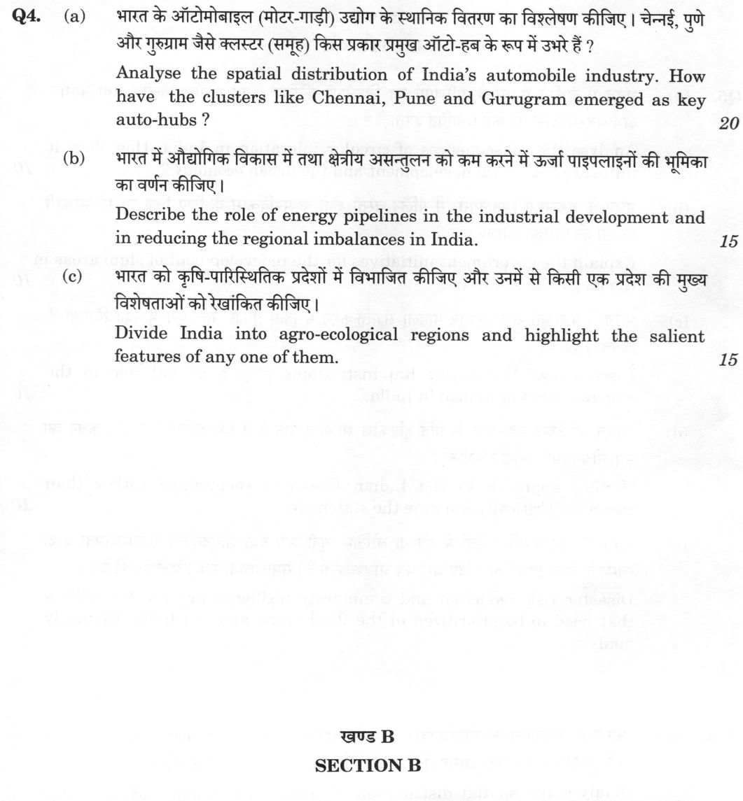
(a) Analyse the spatial distribution of India's automobile industry. How have the clusters like Chennai, Pune and Gurugram…
Analyse the spatial distribution of India's automobile industry. How have the clusters like Chennai, Pune and Gurugram emerged as key auto-hubs ? 20 marks
Describe the role of energy pipelines in the industrial development and in reducing the regional imbalances in India. 15 marks
Divide India into agro-ecological regions and highlight the salient features of any one of them. 15 marks
हिंदी में प्रश्न पढ़ें
भारत के ऑटोमोबाइल (मोटर-गाड़ी) उद्योग के स्थानिक वितरण का विश्लेषण कीजिए। चेन्नई, पुणे और गुरुग्राम जैसे क्लस्टर (समूह) किस प्रकार प्रमुख ऑटो-हब के रूप में उभरे हैं ? (20 अंक)
भारत में औद्योगिक विकास में तथा क्षेत्रीय असंतुलन को कम करने में ऊर्जा पाइपलाइनों की भूमिका का वर्णन कीजिए। (15 अंक)
भारत को कृषि-पारिस्थितिक प्रदेशों में विभाजित कीजिए और उनमें से किसी एक प्रदेश की मुख्य विशेषताओं को रेखांकित कीजिए। (15 अंक)
Model answer
Drafted with AI by UPSC Answer Check against this question's marking rubric, to the expected length. UPSC does not publish answers for Mains — this is one way to score well, not an official key. How we build rubrics and answers.
(a) Spatial distribution of the automobile industry and the Chennai, Pune and Gurugram hubs
The spatial distribution of India's automobile industry is characterised by distinct regional clusters, reflecting a shift from a single-unit, state-controlled model to a multi-nodal, market-driven geography. The industry is concentrated in the North (Gurugram–Manesar–Dharuhera–Bawal, with Maruti's new Kharkhoda plant), the West (Pune–Chakan–Aurangabad and Gujarat's Sanand–Hansalpur), the South (Chennai–Oragadam and Bengaluru–Hosur, including Toyota at Bidadi) and the Centre (Pithampur, with the NATRAX test track), while the East and North-East remain thin.
Chennai has emerged as the "Detroit of India" due to the massive agglomeration of global OEMs. The entry of Hyundai in Sriperumbudur in 1998 triggered a cascade of investments, including Renault-Nissan and Daimler at Oragadam, and the expansion of Ashok Leyland at Ennore. This cluster is supported by the SIPCOT industrial framework and the proximity of the GARC (NATRiP) testing facility at Oragadam.
Pune serves as the western hub, anchored by the Pimpri-Chinchwad, Chakan, and Ranjangaon belts. It hosts major players like Tata Motors, Bajaj, and Mahindra, and is a critical node for the two-wheeler industry. The region benefits from the presence of the ARAI headquarters and a dense network of component suppliers.
Gurugram (and the broader NCR) became a key hub following the entry of Maruti Suzuki in 1983. The cluster expanded to Manesar (Honda) and Dharuhera (Hero MotoCorp), leveraging the massive consumer market of Delhi-NCR.
The emergence of these hubs is driven by agglomeration economies and just-in-time (JIT) component linkages mapped by the ACMA. Policy shifts, including the 1991 delicensing and 100% FDI on the automatic route, allowed global brands to establish local bases. Infrastructure like the Golden Quadrilateral and the NATRiP programme (testing facilities) further consolidated these locations. Because the industry is market-, port- and supplier-oriented rather than raw-material oriented, a Weberian least-cost logic applies only in modified form. While the eastern region remains thin (following the 2014 closure of Hindustan Motors' Uttarpara plant), new EV initiatives under PM E-DRIVE (successor to FAME-II) and PLI are currently reinforcing the existing southern and western clusters.
(b) Energy pipelines, industrial development and regional balance
Energy pipelines serve as the circulatory system of India's industrial economy, facilitating the bulk movement of crude oil, refined products, and natural gas. They are critical for industrial development because they offer the lowest unit cost and energy loss for transport, ensuring a continuous, weather-independent supply to energy-intensive industries. They are regulated as common-carrier infrastructure by the Petroleum and Natural Gas Regulatory Board under the PNGRB Act, 2006, and the national gas grid is central to the target of raising gas to 15 per cent of the primary energy mix by 2030.
In terms of industrial development, the Hazira-Vijaipur-Jagdishpur (HVJ) pipeline, commissioned in 1987 by GAIL, was a transformative project. It enabled the establishment of a northern fertilizer belt and provided a reliable feedstock for power plants. Similarly, the Naharkatiya-Nunmati-Barauni crude pipeline (early 1960s) allowed refineries to be sited in landlocked areas, while the Salaya-Mathura and Mundra-Panipat lines feed inland refineries, and the Kochi-Koottanad-Bengaluru-Mangaluru gas pipeline (2020) serves southern industry. The Jamnagar-Loni LPG pipeline, one of the world's longest, ensures the supply of cooking gas to the northern markets.
Regarding regional imbalances, pipelines have been instrumental in integrating the eastern and north-eastern regions. The Pradhan Mantri Urja Ganga (Jagdishpur-Haldia-Bokaro-Dhamra) pipeline has revived the fertilizer plants at Gorakhpur, Sindri, and Barauni, which had become non-viable due to high gas costs. The North-East Gas Grid (Indradhanush) and the Numaligarh-Siliguri pipeline have provided energy security to the North-East. Furthermore, the India-Bangladesh Friendship Pipeline (2023) marks a significant step in cross-border energy integration.
However, the role of pipelines has critical limits. Their benefits are "corridor-bound," meaning districts off the route gain little. Projects are often delayed by right-of-use (RoU) disputes and land acquisition issues. Several lines run below capacity for want of anchor demand, and transnational projects like TAPI (only the Turkmen–Afghan segment has moved) and IPI remain uncertain for geopolitical reasons. Thus, while pipelines are a necessary tool for balancing regional development, they must be complemented by other infrastructure to be fully effective.
(c) Agro-ecological regions of India and the Hot Arid Western Plain
India’s diverse agro-climatic conditions necessitate a regional approach to agricultural planning. The most authoritative classification is the ICAR-NBSS&LUP (1992) scheme, which divides the country into 20 Agro-Ecological Regions (AERs) and 60 sub-regions. This classification is based on four primary criteria: physiography, bioclimate, soils, and the length of growing period (LGP). This scheme is distinct from the Planning Commission’s 15 agro-climatic zones (1988) and the NARP’s 127 zones, as it provides a more granular basis for crop planning. The regions run from the cold arid Western Himalaya (AER 1) through the hot arid (2–3), hot semi-arid (4–8) and hot sub-humid (9–13) regions, the warm sub-humid to humid Western Himalaya (14), the Bengal–Assam Plain (15), the per-humid Eastern Himalaya and Purvachal hills (16–17), and the Eastern Coastal Plain and Western Ghats–West Coast (18–19), to the islands (20).
Salient Features of the Hot Arid Western Plain (AER-2):
This region, covering western Rajasthan, Kachchh and part of Kathiawar in Gujarat, with small adjoining parts of Haryana and Punjab, is characterised by extreme aridity and high temperatures.
- Bioclimate and LGP: The region has a very short Length of Growing Period (LGP), typically less than 90 days. It experiences high summer temperatures and low, erratic rainfall, making it highly susceptible to drought.
- Soils: The soils are predominantly desert (sandy) soils with saline and alkaline patches, low in organic matter and water-holding capacity; the natural water table is deep, but canal irrigation has raised it locally, causing secondary salinity and waterlogging.
- Agricultural Practices: The cropping pattern is dominated by drought-resistant crops such as bajra (pearl millet), moth, and guar (cluster bean). Traditional agroforestry is built round the khejri tree (Prosopis cineraria).
- Challenges: The region faces significant environmental degradation, including wind erosion and the spread of desertification. The Indira Gandhi Canal (IGNP) project, while providing irrigation, has also led to issues of waterlogging and salinity in the lower reaches.
- Livestock: Because cropping is so risky, livestock is central to livelihoods, particularly sheep, goats and camels, with hardy breeds such as Marwari sheep and Tharparkar and Rathi cattle.
In conclusion, the Hot Arid Western Plain requires specific interventions, such as water conservation, soil improvement, and the promotion of drought-tolerant varieties, to ensure sustainable agricultural development.
How this answer will be evaluated
Evaluation rubric
Each sub-part is marked on its own, against the marks and word limit printed on the paper.
- (a) Two explicit tasks: analyse the spatial distribution of India's automobile industry (the regional pattern, not a company list), and then explain the specific factors behind the emergence of the Chennai, Pune and Gurugram clusters as auto-hubs. Both parts carry weight; the three named hubs must each be dealt with. 20 marks
Must cover
- Chennai as the 'Detroit of India' - Sriperumbudur, Oragadam, Maraimalai Nagar, Ennore; SIPCOT
- Hyundai Sriperumbudur (1998), Renault-Nissan and Daimler at Oragadam, Ashok Leyland Ennore
- Maruti Suzuki Gurgaon (1983) and Manesar; Hero MotoCorp Dharuhera; Honda Manesar/Tapukara
- Pimpri-Chinchwad, Chakan, Ranjangaon, Aurangabad (Tata Motors, Bajaj, Mercedes-Benz, Volkswagen, Mahindra)
- Sanand and Hansalpur (Gujarat); Pithampur and NATRAX; Bidadi and Hosur
- agglomeration economies and just-in-time component linkages (ACMA)
- delicensing of 1991 and 100 percent FDI on the automatic route
- PLI for automobiles and advanced chemistry cells; FAME-II / PM E-DRIVE
- ARAI Pune, GARC Oragadam, NATRiP
- closure of Hindustan Motors' Uttarpara plant (2014) and the eastern gap
Loses marks
- Writing a company roll-call with no spatial analysis - no regions delimited, no explanation of why the pattern is clustered.
- Answering the distribution part but skipping one of the three named hubs (most often Gurugram), which forfeits an essential key point.
- Applying Weber's least-cost theory mechanically as if the industry were raw-material oriented; the auto industry is market-, port- and agglomeration-oriented.
- Misplacing plants - putting Hyundai in Bengaluru, Toyota Kirloskar in Chennai instead of Bidadi, or Ashok Leyland's main works outside Ennore/Hosur.
- Ignoring the eastern and north-eastern void, and the new EV/battery cluster geography, so the answer reads dated.
Earns more
- Establishes the overall spatial pattern and scale: production is clustered in a handful of nodes - northern (Gurugram-Manesar-Dharuhera-Bawal-Neemrana), western (Pune-Pimpri Chinchwad-Chakan-Ranjangaon-Aurangabad-Nashik and Gujarat's Sanand-Halol-Hansalpur), southern (Chennai belt and Bengaluru-Hosur), central (Pithampur near Indore, with the NATRAX high-speed test track) - and thin to absent in eastern and north-eastern India, especially after Hindustan Motors' Uttarpara plant closed in 2014; notes that India is among the largest automobile markets in the world, the largest producer of two- and three-wheelers, and that the sector accounts for roughly 7 percent of GDP and close to half of manufacturing GVA on industry (SIAM) estimates.
- Other nodes and the persisting imbalance: Pithampur (the 'Detroit of Madhya Pradesh') with NATRAX; Tata Motors at Jamshedpur (India's pioneer commercial-vehicle works), Lucknow and Pantnagar; Hero at Haridwar under the hill-state fiscal package; against the near absence of assembly in Bihar, Odisha, West Bengal (post-2014) and the North-East despite market size.
- Explains the general location logic: agglomeration and localisation economies with just-in-time supplier proximity (ACMA-mapped component clusters typically within a short radius of the assembly plant); market orientation rather than raw-material orientation, so a Weberian least-cost framework must be modified by market and port pull and by ubiquitous inputs; policy history - Maruti's entry, delicensing in 1991, 100 percent FDI on the automatic route, state capital subsidies, SEZs and Production Linked Incentive schemes for autos and advanced chemistry cell batteries; skilled labour, engineering institutions and testing infrastructure under the NATRiP programme; expressways and the Golden Quadrilateral; and the emerging electric-vehicle geography under FAME-II and PM E-DRIVE (Ola's Futurefactory in Krishnagiri, Ather at Hosur, battery and cell plants in Gujarat and Karnataka), which is reinforcing the existing southern and western clusters rather than creating new regions.
- (b) Describe pipelines in two distinct roles: as an input to industrial development, and as an instrument for reducing regional imbalance. Named pipelines with the industries they created are expected; a critical note on the limits of pipelines as a balancing tool raises the answer. 15 marks
Must cover
- Hazira-Vijaipur-Jagdishpur (HVJ) pipeline, 1987, GAIL - first cross-country gas pipeline
- Jagdishpur-Haldia-Bokaro-Dhamra pipeline / Pradhan Mantri Urja Ganga
- revival of Gorakhpur, Sindri and Barauni fertilizer plants
- North-East Gas Grid / Indradhanush Gas Grid
- Naharkatiya-Nunmati-Barauni crude pipeline (early 1960s)
- Salaya-Mathura, Mundra-Panipat, Paradip-Haldia-Durgapur, Numaligarh-Siliguri
- Jamnagar-Loni LPG pipeline
- Kochi-Koottanad-Bengaluru-Mangaluru pipeline
- PNGRB Act 2006 and common-carrier/unified tariff regime
- target of 15 percent gas in the primary energy mix by 2030; national gas grid
- India-Bangladesh Friendship Pipeline (2023)
- TAPI and IPI as stalled transnational projects
Loses marks
- Listing pipelines without connecting any of them to an industry, plant or region that they actually enabled.
- Omitting the regional-imbalance half of the question, or asserting balance benefits without naming the eastern/north-eastern grids.
- Getting the geography wrong - describing HVJ as running to Haldia, or Urja Ganga as a western-India line, or placing Numaligarh in Bihar.
- No critical note at all, so the corridor-bound, low-utilisation and right-of-use limitations are missed.
- Confusing gas pipelines with LNG terminals or with power transmission corridors.
Earns more
- Explains why pipelines are developmentally significant: lowest unit cost and lowest energy loss for bulk movement of crude, petroleum products and gas; continuous, weather-independent, land-saving and safer than road; but very high fixed cost, single-commodity inflexibility and dependence on an anchor load - hence they are regulated as common-carrier infrastructure by the Petroleum and Natural Gas Regulatory Board under the PNGRB Act, 2006.
- Crude and product pipelines and their locational effect: the Naharkatiya-Nunmati-Barauni line (built in the early 1960s), India's first crude pipeline, which allowed refineries to be sited in landlocked Assam and Bihar; Salaya-Mathura and Mundra-Panipat feeding inland refineries; Paradip-Haldia-Durgapur and Numaligarh-Siliguri product lines serving eastern and north-eastern markets; the Jamnagar-Loni LPG pipeline (of the order of 1,250 km, one of the world's longest LPG lines) supplying the northern LPG market; and the India-Bangladesh Friendship Pipeline from Siliguri to Parbatipur commissioned in 2023, India's first cross-border product pipeline.
- Critical limits: the benefit is linear and corridor-bound rather than areal, so districts off the route gain little; right-of-use and land acquisition disputes and crop compensation delay projects; difficult terrain, seismicity and flooding in the Himalaya and the North-East raise cost; several lines run well below capacity (Kochi-Mangaluru for years) because anchor industrial demand is missing; tariff structure (the move to unified/zonal tariffs) determines whether distant users actually get affordable gas; theft and pilferage on product lines; and transnational projects that would have transformed supply - TAPI and Iran-Pakistan-India - remain stalled for geopolitical reasons. Hence pipelines are a necessary but partial answer to regional imbalance, which also needs power, roads, skills and markets.
- (c) Two tasks: first divide India into agro-ecological regions using a recognised classification (with the criteria on which it rests), and then highlight the salient features of any ONE of those regions. The candidate chooses the region; the divisions must be from an authoritative scheme, not invented. 15 marks
Must cover
- ICAR-NBSS&LUP, Nagpur (1992) - 20 agro-ecological regions and 60 agro-ecological sub-regions
- delineation criteria: physiography, bioclimate, soils, length of growing period (LGP)
- distinction from the Planning Commission's 15 agro-climatic zones (1988) and NARP's 127 zones
- moisture regimes: arid, semi-arid, sub-humid (dry/moist), humid, per-humid
- at least one region described with rainfall range, LGP, soils, crops and problems
- for the arid region: Indira Gandhi Nahar Pariyojana, khejri (Prosopis cineraria), bajra-moth-guar, wind erosion and secondary salinisation
Loses marks
- Inventing a division, or presenting physiographic divisions of India (Himalaya, Plains, Plateau, Coast, Islands) as agro-ecological regions.
- Conflating the NBSS&LUP 20 agro-ecological regions with the Planning Commission's 15 agro-climatic zones and mixing names from both lists.
- Listing the regions but never taking up one region in the depth the question demands ('highlight the salient features of any one of them').
- Describing a chosen region only climatically, with no soils, crops, livestock or land-degradation problems.
- Omitting length of growing period, which is the distinguishing criterion of this classification.
Earns more
- Enumerates a substantial part of the 20 regions with their moisture regime and length of growing period, for example: (1) cold arid Western Himalaya - Ladakh, LGP under 90 days; (2) hot arid Western Plain and Kachchh Peninsula, desert and saline soils; (3) hot arid Deccan Plateau (Karnataka), red and black soils; (4) hot semi-arid Northern Plain and Central Highlands including the Aravalli, alluvium-derived soils, LGP 90-150 days; (5) hot semi-arid Central (Malwa) Highlands, Gujarat Plain and Kathiawar, medium-deep black soils; (6) hot semi-arid Deccan Plateau, shallow to medium black soils; (7) hot semi-arid Deccan (Telangana) Plateau and Eastern Ghats, red and black soils; (8) hot semi-arid Eastern Ghats, Tamil Nadu Uplands and Karnataka Plateau, red loamy soils; (9) hot sub-humid (dry) Northern Plain, LGP 150-180 days; (10) hot sub-humid Central Highlands - Malwa, Bundelkhand and Satpura, black and red soils; (11) hot sub-humid Eastern (Chhattisgarh) Plateau, red and yellow soils; (12) hot sub-humid Eastern (Chhotanagpur) Plateau and Eastern Ghats, red and lateritic soils; (13) hot sub-humid (moist) Eastern Plain, LGP 180-210 days; (14) warm sub-humid to humid Western Himalaya, brown forest and podzolic soils; (15) hot sub-humid to humid Bengal and Assam Plain, LGP 210-270 days; (16) warm per-humid Eastern Himalaya, brown and red hill soils, LGP over 270 days; (17) warm per-humid North-Eastern (Purvachal) Hills, red and lateritic soils; (18) hot sub-humid to semi-arid Eastern Coastal Plain, coastal alluvium; (19) hot humid to per-humid Western Ghats and West Coast Plain, red, lateritic and alluvial soils; (20) hot humid to per-humid islands of Andaman-Nicobar and Lakshadweep.
- Explains the criteria substantively rather than just listing them - length of growing period as the number of days of assured soil-moisture availability derived from rainfall against potential evapotranspiration; the moisture availability index; and soil depth/texture as the determinant of water-holding capacity - and notes that LGP is what converts climate data into crop-planning advice (single crop, double crop or plantation potential).
- Notes the planning application: agro-ecological regionalisation underpins land-capability-based crop planning, watershed and dryland development, the district agriculture plans, contingency crop planning and the ICAR research-station network - i.e. it is a tool, not just a taxonomy. A sketch map showing the regions adds value.
What "Analyse" is asking you to do
Break the subject into its working parts and show how they act on each other. The marks are in the interconnections — which factor drives which, and what the resulting structure explains — not in the inventory of factors.
Structure that answers it
Define the whole → separate it into its parts → show which part drives which → what that interaction produces → what the structure implies
Where marks are lost
A flat list of causes with no account of which drives which. An answer of neatly separated headings, each self-contained, scores as description.
Practice this exact question
Write your answer and it is marked point by point against the model answer above — what you covered, what you missed, what you got wrong.
Evaluate my answer →More from Geography 2026 Paper II
- Q1 (a) On the outline map of India provided to you, mark the location of all of the followin…
- Q2 (a) The relationship between El Niño and the Indian monsoon is becoming complex under the…
- Q3 (a) Examine the causes and consequences of crop diversification in India. How can crop di…
- Q4 (a) Analyse the spatial distribution of India's automobile industry. How have the cluster…
- Q5 (a) Analyse the consequences of circular migration in India. How does it influence both r…
- Q6 (a) Examine the trends in fertility rates across Indian states over time. How are they pr…
- Q7 (a) Why is it difficult to improve the quality of air during the winter season in the Gan…