Paper II — Q8
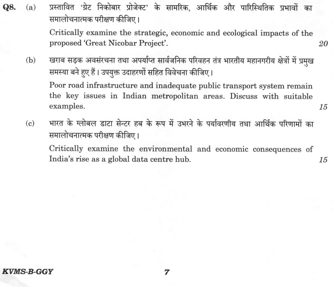
(a) Critically examine the strategic, economic and ecological impacts of the proposed ‘Great Nicobar Project’. (20 marks) (b)…
Critically examine the strategic, economic and ecological impacts of the proposed ‘Great Nicobar Project’. 20 marks
Poor road infrastructure and inadequate public transport system remain the key issues in Indian metropolitan areas. Discuss with suitable examples. 15 marks
Critically examine the environmental and economic consequences of India’s rise as a global data centre hub. 15 marks
हिंदी में प्रश्न पढ़ें
प्रस्तावित ‘ग्रेट निकोबार प्रोजेक्ट’ के सामरिक, आर्थिक और पारिस्थितिक प्रभावों का समालोचनात्मक परीक्षण कीजिए । (20 अंक)
खराब सड़क अवसंरचना तथा अपर्याप्त सार्वजनिक परिवहन तंत्र भारतीय महानगरीय क्षेत्रों में प्रमुख समस्या बने हुए हैं । उपयुक्त उदाहरणों सहित विवेचना कीजिए । (15 अंक)
भारत के ग्लोबल डाटा सेंटर हब के रूप में उभरने के पर्यावरणीय तथा आर्थिक परिणामों का समालोचनात्मक परीक्षण कीजिए । (15 अंक)
Model answer
Drafted with AI by UPSC Answer Check against this question's marking rubric, to the expected length. UPSC does not publish answers for Mains — this is one way to score well, not an official key. How we build rubrics and answers.
(a) The Great Nicobar Project: strategic, economic and ecological impacts
The Great Nicobar Project, a NITI Aayog conception implemented by ANIIDCO at an estimated cost of ₹72,000 crore, aims to develop an International Container Transhipment Terminal (ICTT) at Galathea Bay, a greenfield dual-use international airport, a township and a gas-and-solar power plant.
Strategic Impact: The project’s primary rationale is geo-strategic. Overlooking the Six Degree Channel, about 150 km from Sumatra and at the western approach to the Strait of Malacca, it leverages India’s southernmost point, Indira Point, to secure maritime interests. It complements the Andaman and Nicobar Command (ANC) and offers a critical alternative to transhipment currently routed through Colombo, Singapore, and Port Klang.
Economic Impact: Economically, the project aims to capture relay-cargo demand and reduce logistics costs. However, the case is unproven; the ICTT will compete with Colombo and Singapore and with India's own Vizhinjam port, commissioned in 2025, and a remote island terminal must attract shipping lines without a large local hinterland. The economic viability hinges on whether the massive capital outlay can be recovered through actual cargo volume.
Ecological Impact: The ecological and social costs are severe. The site lies within the Great Nicobar Biosphere Reserve (UNESCO MAB since 2013) and the Galathea National Park, home to the giant leatherback turtle and the endemic Nicobar megapode. Denotification of the Galathea Bay Wildlife Sanctuary (2021) and the diversion of about 130 sq km of forest, implying the felling of several lakh trees, are highly disruptive, and compensatory afforestation proposed in mainland states such as Haryana is not ecologically equivalent to tropical island rainforest, coral reef and mangrove. Furthermore, the island is home to the Shompen, a Particularly Vulnerable Tribal Group (PVTG), and to Nicobarese communities; for the Shompen, contact, disease and loss of forest pose an existential risk, and the local tribal council has questioned how its consent was recorded. The island’s location in Seismic Zone V, where Indira Point subsided during the 2004 tsunami, adds a significant hazard dimension. The National Green Tribunal in 2023 upheld the clearances but set up a high-powered committee to revisit aspects of them.
Verdict: While the strategic case is strong, the ecological and tribal costs are largely irreversible. A reasoned verdict suggests phased construction with a legally protected Shompen exclusion zone, independent scientific monitoring, and tsunami-resilient design.
(b) Roads and public transport in Indian metropolitan areas
Indian metropolitan areas face a critical mismatch between rapid urbanization and infrastructure growth. Census 2011 recorded 37.7 crore urban residents (31.2 per cent) in 53 million-plus agglomerations, and the urban share is projected to approach 40 per cent by 2030, while the vehicle fleet has grown far faster than road length. This growth has outpaced road capacity; Indian metros devote a low share of land to roads (approx. 10% in Mumbai and Bengaluru, 20% in Delhi) compared to the 25-30% in planned cities. Congestion is chronic in Bengaluru, Mumbai and Delhi, and national road crash fatalities exceed 1.7 lakh a year, many of them pedestrians and two-wheeler riders in cities.
Public transport remains inadequate. While the metro network has exceeded 1,000 route km across twenty cities, ridership often falls short of projections in cities like Kochi and Jaipur. Buses, which carry the majority of urban passengers, suffer from a significant fleet shortfall against the benchmark of 40-60 buses per lakh population. Ahmedabad's Janmarg BRTS (2009) shows what dedicated bus lanes can do, but examples of failure include the dismantled Delhi BRT (2016) and the chronic crush loads and track fatalities on Mumbai suburban rail.
The policy response includes the National Urban Transport Policy (2006) and the Metro Rail Policy (2017), which mandate transit-oriented development and a unified Metropolitan Transport Authority (UMTA). Recent initiatives like PM e-Bus Sewa (2023), the National Common Mobility Card (2019), and the Namo Bharat RRTS (2023) aim to modernize the sector. However, the primary gap remains institutional: most metros lack a functioning UMTA, integrated network planning, and priced parking. Without demand management, new capacity like the Mumbai Trans Harbour Link (2024) is often offset by induced demand.
(c) India as a global data-centre hub: environmental and economic consequences
India’s emergence as a global data centre hub is driven by the RBI’s 2018 data localisation norms, the Digital Personal Data Protection (DPDP) Act, 2023 (with Rules notified in 2025), infrastructure status for data centres (2022), state data-centre policies and rising cloud and AI demand. Geographically, this growth is concentrated in Mumbai (which hosts nearly half of the capacity), followed by Chennai, Hyderabad, and Bengaluru, largely due to the presence of international cable landings.
Economic Consequences: The economic gains are substantial, attracting significant Foreign Direct Investment (FDI) and supporting the growth of Global Capability Centres (GCCs). Low latency and local data sovereignty have made India a preferred destination for global tech firms. However, the sector is capital-intensive rather than labour-intensive, meaning it generates relatively few direct employment opportunities compared to its economic footprint.
Environmental Consequences: The environmental costs are significant. Data centres are energy-intensive, and in India, a large portion of this power is still derived from coal, leading to a high carbon footprint. Cooling uses a large share of their power (captured in power usage effectiveness, PUE) and, with evaporative systems, large volumes of water, a serious risk in cities that have already faced acute water crises, such as Chennai (2019) and Bengaluru (2024). Additionally, diesel generators for backup power add local air pollution, and short hardware refresh cycles add to e-waste, which the E-Waste (Management) Rules, 2022 regulate only weakly in practice.
Verdict: The economic case is real but narrower than headline investment figures suggest. To sustain this growth, India must move to round-the-clock renewable PPAs and use the Carbon Credit Trading Scheme under the Energy Conservation (Amendment) Act, 2022, adopt liquid and immersion cooling, mandate disclosure of power and water use, and site new capacity in cooler, water-abundant or renewable-rich locations rather than water-stressed metros.
How this answer will be evaluated
Evaluation rubric
Each sub-part is marked on its own, against the marks and word limit printed on the paper.
- (a) Critically examine the proposed Great Nicobar Project under three explicitly named heads - strategic, economic and ecological impacts - weighing benefits against costs under each, and arriving at a reasoned verdict. The project must first be described accurately; the social/tribal and hazard dimensions belong under the ecological-environmental head. 20 marks
Must cover
- International Container Transhipment Terminal at Galathea Bay; greenfield airport; township; power plant
- NITI Aayog conception; ANIIDCO implementation; cost of the order of Rs 72,000 crore
- Six Degree Channel; proximity to the Strait of Malacca; Indira Point as India's southernmost point
- Andaman and Nicobar Command (tri-service, 2001)
- transhipment currently routed through Colombo, Singapore and Port Klang; Vizhinjam as competition
- Great Nicobar Biosphere Reserve (1989; UNESCO MAB since 2013); Campbell Bay and Galathea national parks
- giant leatherback turtle nesting at Galathea Bay; Nicobar megapode; Nicobar long-tailed macaque
- denotification of the Galathea Bay Wildlife Sanctuary (2021); diversion of about 130 sq km of forest
- Shompen (a PVTG) and Nicobarese; tribal reserve denotification and contested consent
- seismic zone V; the 2004 Indian Ocean earthquake and tsunami; subsidence at Indira Point
- National Green Tribunal high-powered committee review (2023); compensatory afforestation in mainland states
Loses marks
- Not describing the project - an answer that never names the Galathea Bay transhipment terminal, the airport, the township and the power plant cannot be examined 'critically'.
- Covering only the ecological objections and skipping the strategic and economic heads that the question names, or vice versa.
- Omitting the Shompen entirely, which is the single most distinctive social issue in this case.
- Getting the geography wrong - placing Great Nicobar near the Ten Degree Channel (which separates Little Andaman from Car Nicobar) rather than the Six Degree Channel, or confusing Indira Point with Indira Col.
- Giving no verdict, or an absolutist verdict ('the project must be scrapped' / 'environmental concerns are exaggerated') without weighing the trade-offs the question sets up.
Earns more
- Ecological impacts: the project area lies within the Great Nicobar Biosphere Reserve (1989, in the UNESCO Man and the Biosphere network since 2013), which contains the Campbell Bay and Galathea national parks; Galathea Bay is India's most important nesting beach for the giant leatherback turtle, and the island holds the endemic Nicobar megapode, the Nicobar long-tailed macaque and tree shrew, saltwater crocodiles, coral reefs and mangroves; the Galathea Bay Wildlife Sanctuary was denotified in 2021 to enable the port; diversion of roughly 130 sq km - about a seventh of the island - implies felling on the order of eight to nine lakh trees; and compensatory afforestation proposed largely in mainland states such as Haryana and Madhya Pradesh is ecologically non-equivalent to tropical evergreen island forest, while coral translocation and turtle-nesting relocation are unproven at this scale.
- Social and hazard dimensions: the island is home to the Shompen, a particularly vulnerable tribal group of only a few hundred people living largely uncontacted in the interior, and to Nicobarese communities; parts of the tribal reserve were denotified in 2021 with an equivalent area notified elsewhere, the local tribal council subsequently questioned the basis on which its consent was recorded, and international scholars publicly warned in 2024 of existential risk to the Shompen from contact, disease and displacement; the island lies in seismic zone V and was among the worst affected by the December 2004 earthquake and tsunami, when Indira Point subsided by a few metres - so exposing a projected population of lakhs and multi-billion-dollar assets to a recurrent tsunamigenic subduction zone is a first-order, not a residual, risk.
- Process critique and reasoned verdict: clearances rested on environmental impact assessment with limited seasonal baseline data and contested cumulative-impact analysis; the National Green Tribunal's eastern zone bench directed a high-powered committee to revisit aspects of the clearance in 2023. The defensible conclusion is differentiated - the strategic case is strong and time-sensitive; the economic case is plausible but unproven and should be staged against demonstrated relay-cargo demand; the ecological and tribal costs are largely irreversible. Hence phased construction with independent scientific monitoring, a legally protected Shompen exclusion zone with an enforced no-contact protocol, on-island rather than mainland compensatory measures, tsunami-resilient siting and design, and a transparent review at each phase - rather than either blanket approval or outright rejection.
- (b) Discuss two linked deficits in Indian metropolitan areas - road infrastructure and public transport - with suitable named examples, their consequences, and the policy response and its gaps. Generic urban-problem writing without named cities and schemes will not do. 15 marks
Must cover
- Census 2011 urban population 37.7 crore (31.2 percent); 53 million-plus agglomerations
- low share of urban land under roads in Indian metros
- bus fleet shortfall against the benchmark of about 40-60 buses per lakh population
- metro network exceeding 1,000 route km across more than twenty cities; ridership shortfalls in Kochi, Jaipur, Lucknow
- Ahmedabad Janmarg BRTS (2009) versus the dismantled Delhi BRT (2016)
- Mumbai suburban rail crush loads and track fatalities
- National Urban Transport Policy, 2006 - 'move people, not vehicles'
- Metro Rail Policy, 2017 - alternatives analysis, comprehensive mobility plan, UMTA, transit-oriented development
- PM e-Bus Sewa (2023); FAME / PM E-DRIVE; National Common Mobility Card (2019)
- Namo Bharat RRTS (Delhi-Meerut, 2023); Mumbai Trans Harbour Link (2024)
- road crash fatalities exceeding 1.7 lakh a year; congestion cost estimates
Loses marks
- Writing a generic 'problems of urbanisation' answer covering housing, water and sanitation instead of staying on roads and public transport.
- Giving no named city example, although the question explicitly asks for suitable examples.
- Equating public transport with metro rail alone and ignoring buses, which carry far more urban passengers and are where the deficit is largest.
- Proposing only flyovers and road widening as the solution - induced demand means added road capacity refills, which a good answer should say.
- Naming schemes without dates or content (calling NUTP a recent scheme, or attributing PM e-Bus Sewa to the Ministry of Road Transport rather than Housing and Urban Affairs).
Earns more
- Establishes the mismatch with data: Census 2011 counted 37.7 crore urban residents (31.2 percent) in 7,935 towns with 53 million-plus agglomerations, and the urban share is projected to approach 40 percent by 2030, while registered motor vehicles have multiplied several-fold to well over 30 crore nationally; road space cannot keep pace - Indian metros devote a low share of urban land to roads (of the order of a tenth in Mumbai and Bengaluru, around a fifth in Delhi, against the 25-30 percent typical of planned cities) and road length grows far more slowly than the vehicle fleet.
- Policy response and the gaps that remain: the National Urban Transport Policy (2006) and its principle of moving people rather than vehicles; the Metro Rail Policy (2017) requiring an alternatives analysis, comprehensive mobility plans, transit-oriented development and a unified metropolitan transport authority as conditions of central support; PM e-Bus Sewa (2023) for ten thousand electric buses in 169 cities, backed by a payment security mechanism, alongside FAME and PM E-DRIVE; the National Common Mobility Card (2019); intelligent transport systems, adaptive signals and integrated command and control centres under the Smart Cities Mission; and new capacity such as the Delhi-Meerut Regional Rapid Transit System (Namo Bharat, from 2023) and the Mumbai Trans Harbour Link (2024). What is still missing is institutional - most metropolitan areas lack a functioning unified transport authority, integrated network planning and fares, priced parking and demand management, protected non-motorised infrastructure and dedicated bus lanes, and a predictable operating subsidy that lets bus fleets grow.
- (c) Critically examine both the environmental AND the economic consequences of India's emergence as a global data-centre hub - stating the phenomenon and its geography, weighing gains against costs under each head, and arriving at a qualified verdict rather than a celebration. 15 marks
Must cover
- concentration of capacity in Mumbai (about half), then Chennai, Hyderabad, Bengaluru, Pune, Delhi-NCR
- submarine cable landing stations as the reason for coastal-metro concentration
- RBI payment-data localisation directive (2018); Digital Personal Data Protection Act, 2023
- infrastructure status for data centres (Harmonised Master List, 2022); state data-centre policies
- capital-intensive but employment-light - few direct jobs per unit of investment
- coal-dominated grid and the carbon footprint of continuous IT load
- power usage effectiveness (PUE) and cooling energy share
- water for evaporative cooling; Chennai 2019 and Bengaluru 2024 water crises
- e-waste and the E-Waste (Management) Rules, 2022; diesel-generator backup emissions
- round-the-clock renewable PPAs and open access; Energy Conservation (Amendment) Act, 2022 carbon credit trading scheme
- liquid/immersion cooling and siting in cooler, water-abundant locations
Loses marks
- Treating the question as a celebration of Digital India and listing only investment figures and benefits - 'critically examine' requires costs under both heads.
- Covering environment but not economics, or economics but not environment, when both are explicitly named.
- Claiming large direct employment from data centres; they are among the least labour-intensive forms of large capital investment, and a good answer says so.
- Ignoring water entirely, although water for cooling in Chennai, Bengaluru and Pune is the sharpest local conflict.
- Quoting invented capacity or consumption figures; approximate magnitudes with a stated basis are safer and are marked as correct.
Earns more
- Economic gains: large capital inflow and foreign direct investment into construction, power and cooling equipment; data sovereignty and lower latency for Indian users and regulators; support for the cloud, global capability centre and IT-services export economy; real-estate value creation and ancillary demand for fibre, transformers, UPS systems, diesel generators and civil works; industrial diversification into second-tier cities; and construction-phase employment and state revenues.
- Mitigation and a qualified verdict: technically, liquid and immersion cooling, free-air and closed-loop systems, higher operating set-points, waste-heat recovery and better power and water usage effectiveness can cut both footprints sharply; commercially, round-the-clock renewable power purchase agreements and open access - easier under several state policies and under the carbon credit trading scheme created by the Energy Conservation (Amendment) Act, 2022 - can decouple growth from coal; spatially, siting in cooler, water-abundant or renewable-rich locations rather than water-stressed metros is the single highest-leverage decision. What is missing is regulation: India does not yet mandate disclosure of power and water usage effectiveness for data centres, does not condition incentives on renewable sourcing or water efficiency, and enforces e-waste extended producer responsibility weakly. Verdict: the economic case is real but narrower than the headline investment numbers suggest, and the environmental cost is manageable only if sourcing, siting, water and e-waste rules are set now, before the build-out locks the pattern in.
What "Critically examine" is asking you to do
Test the proposition the question puts to you and return a finding on how far it holds. Examine stems carry a claim, or ask whether something has happened, and expect evidence weighed both ways before the extent is stated — often with remedial measures attached. “Critically” is not a section added at the end: name the yardstick you are judging by — the evidence, the stated objective, a constitutional principle, a rival explanation — and let a verdict close each part of the body. Where the question quotes a claim, that verdict must land on the claim itself, accepted, qualified or rejected, and not on the theme in general.
Structure that answers it
Restate the claim as the question frames it → evidence that supports it → evidence that undercuts it → the conditions under which it holds → verdict on how far it stands
Where marks are lost
Merits in one paragraph, demerits in the next, and a conclusion calling for a balanced and holistic approach. That is a survey with the judgement left out and it holds the answer in the middle band. The opposite error is reading “critically” as permission to attack — and with the odd pairings, critically describe or critically explain, the exposition still carries most of the marks, the judgement being a layer on it rather than a substitute for it.
Practice this exact question
Write your answer and it is marked point by point against the model answer above — what you covered, what you missed, what you got wrong.
Evaluate my answer →More from Geography 2026 Paper II
- Q5 (a) Analyse the consequences of circular migration in India. How does it influence both r…
- Q6 (a) Examine the trends in fertility rates across Indian states over time. How are they pr…
- Q7 (a) Why is it difficult to improve the quality of air during the winter season in the Gan…
- Q8 (a) Critically examine the strategic, economic and ecological impacts of the proposed ‘Gr…