Paper I — Q1
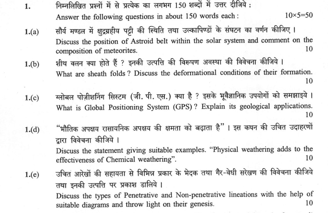
Answer the following questions in about 150 words each: (a) Discuss the position of Astroid belt within the solar system and…
Answer the following questions in about 150 words each: Discuss the position of Astroid belt within the solar system and comment on the composition of meteorites. 10 marks
What are sheath folds ? Discuss the deformational conditions of their formation. 10 marks
What is Global Positioning System (GPS) ? Explain its geological applications. 10 marks
Discuss the statement giving suitable examples. "Physical weathering adds to the effectiveness of Chemical weathering". 10 marks
Discuss the types of Penetrative and Non-penetrative lineations with the help of suitable diagrams and throw light on their genesis. 10 marks
हिंदी में प्रश्न पढ़ें
निम्नलिखित प्रश्नों में से प्रत्येक का लगभग 150 शब्दों में उत्तर दीजिए : सौर्य मण्डल में क्षुद्रग्रहीय पट्टी की स्थिति तथा उल्कापिंडों के संघटन का वर्णन कीजिए । (10 अंक)
शीथ वलन क्या होते हैं ? इनकी उत्पत्ति की विरूपण अवस्था की विवेचना कीजिए । (10 अंक)
ग्लोबल पोजिशनिंग सिस्टम (जी. पी. एस.) क्या है ? इसके भूवैज्ञानिक उपयोगों को समझाइये । (10 अंक)
"भौतिक अपक्षय रासायनिक अपक्षय की क्षमता को बढ़ाता है" । इस कथन की उचित उदाहरणों द्वारा विवेचना कीजिए । (10 अंक)
उचित आरेखों की सहायता से विभिन्न प्रकार के भेदक तथा गैर-भेदी सरेखण की विवेचना कीजिये तथा इनकी उत्पत्ति पर प्रकाश डालिये । (10 अंक)
Model answer
Written by UPSC Answer Check against this question's marking rubric, to the 150-word length. UPSC does not publish answers for Mains — this is one way to score well, not an official key.
(a) Asteroid belt and meteorites The asteroid belt occupies the main region between Mars and Jupiter, roughly 2.1–3.3 AU from the Sun, with Mars at about 1.5 AU and Jupiter at 5.2 AU. It is not a continuous ring but a sparse population of rocky and metallic bodies, with Kirkwood gaps at orbital resonances with Jupiter, where gravitational perturbations remove or prevent accumulation of asteroids. Meteorites, the terrestrial remnants of this and other small-body populations, are grouped by composition and parent-body history. Chondrites are primitive, retaining chondrules and volatile-rich minerals; carbonaceous chondrites are especially important because they preserve refractory inclusions, water-bearing phases and amino acids, informing early Solar System chemistry. Achondrites are igneous, differentiated products of crust, mantle or impact breccias. Iron meteorites are metallic core material, while stony-iron meteorites include pallasites, often interpreted as core–mantle boundary material, and mesosiderites, impact-mixed breccias of metal and crustal silicates. Thus the belt’s position and meteorite composition together record accretion, differentiation and dynamical stripping.
(b) Sheath folds Sheath folds are highly non-cylindrical folds whose hinge line is curved within the XY plane of the finite-strain ellipsoid, i.e. the foliation or shear plane, rather than remaining straight. In a sketch, the fold axis bends in the shear plane, limbs thin, and the core thickens; successive sections across the curved hinge produce eye-shaped patterns. These are not Ramsay Type-3 interference patterns but cross-sections of a single progressive, non-coaxial deformation. They form where large finite shear strain, commonly γ > 10, is concentrated in mylonitic or ultramylonitic shear zones, such as in the Himalayan or Indian orogenic belts. Non-coaxial deformation is essential: principal strain axes rotate, the fold axis is progressively bent, and foliation wraps around the core. High differential stress, ductile flow, and strain partitioning between a strong core and weaker limbs localise the structure. Thus sheath folds record intense progressive shear in the XY plane, not simple interference geometry.
(c) GPS Global Positioning System (GPS) is a satellite-based geodetic system, originally the NAVSTAR constellation, in which a receiver determines its position by trilateration using time-stamped signals from at least four satellites. Differential GPS improves accuracy by correcting satellite and atmospheric errors using a reference station, typically giving sub-meter to centimetre accuracy; sub-millimetre geodetic precision is achieved by static or continuous GPS with carrier-phase processing. Geologically, GPS measures crustal deformation directly. In India, GSI’s geodetic network and other observatories track plate motions, showing Himalayan convergence of about 18 mm/yr, strain accumulation across the Main Thrust Front, and post-seismic relaxation after earthquakes. GPS also monitors earthquake cycles by measuring interseismic locking and coseismic slip, detects slow landslides and subsidence, and constrains fault kinematics, volcanic uplift, and tectonic block rotation. Thus GPS converts satellite geometry into quantitative strain data for neotectonics, hazard mapping and geodynamics.
(d) Physical weathering synergy Physical weathering adds to chemical weathering because mechanical disintegration increases the surface area and permeability of rock, allowing water, oxygen and acids to penetrate fresh surfaces. Fracturing, exfoliation, frost wedging and unloading create joints and pores that concentrate chemical reactions, so a rock that is merely broken down is more readily altered, dissolved or oxidised. In spheroidal weathering of jointed granite or basalt, such as in the Western Ghats or Deccan traps, joint-controlled fracturing exposes fresh feldspar to hydration and hydrolysis, producing rounded boulders and regolith. In laterite profiles of tropical India, physical breakdown of lateritic crust and exfoliation of saprolite enhances leaching of silica and concentration of iron and aluminium, aiding lateritization. In the Himalayas, freeze-thaw action fractures rocks, and the new surfaces accelerate oxidation of pyrite or ferrous minerals, producing gossans and red soils. Thus physical weathering is not merely preparatory; it controls the rate, depth and distribution of chemical weathering by continually renewing reactive surfaces.
(e) Lineations Penetrative lineations are continuous, three-dimensional structures that cut through the rock mass, whereas non-penetrative lineations are discrete surface features. A simple diagram of penetrative lineation would show L1 stretching lineation, mineral lineation such as aligned hornblende, or intersection lineation formed where two foliations cross, all extending through the outcrop. They form by progressive ductile strain: mineral grains stretch, rotate or align in the XY plane, and foliation S1 defines a penetrative fabric. Non-penetrative lineations include millions, which are short, curved or straight grooves on fault or shear surfaces, and slickenside striations, which are polished and striated surfaces produced by frictional slip. Crenulation lineations are usually penetrative L2 structures formed by superposed folding of an earlier foliation; only where crenulation cleavage is spaced or discontinuous can they be treated as non-penetrative. Genesis differs: penetrative lineations record finite strain and flow in the rock, while non-penetrative lineations record local slip, pressure-solution or surface abrasion. Scale-dependent strain partitioning controls whether lineations are penetrative or surface-localised, and together they reveal shear sense and tectonic sequence.
What "Discuss" is asking you to do
Lay the issue out from more than one side — how it arose, what is claimed for it, what is held against it, and where it now stands. UPSC attaches discuss to broad topics with several live dimensions, so coverage of the dimensions earns more than the strength of your opinion.
Structure that answers it
Set the issue up → the case as it is made → the case against → the dimension both sides leave out → where the balance now lies
Where marks are lost
Listing facts with no thread between them, or arguing one side throughout and calling it a discussion.
How this answer will be evaluated
Approach
Framework: Geology Paper 1: Define > Process > Field/Petrographic Evidence > Indian Example. (a) discuss: intro > 3-4 dimensions > example > balanced close | (b) discuss: intro > 3-4 dimensions > example > balanced close | (c) explain: definition/context > points in order > small example > short close | (d) discuss: intro > 3-4 dimensions > example > balanced close | (e) discuss: intro > 3-4 dimensions > example > balanced close Full marks: Precise definitions, correct diagrams, Indian examples, clear causal links.
Key points expected
- Location between Mars and Jupiter
- Composition: silicates, iron, nickel
- Types: chondritic, achondritic, iron
- Origin: failed planet formation
- Definition: isoclinal fold with axial plane
- Formation: high strain, ductile flow
- Mechanism: shear zone development
- Sketch of fold geometry
Evaluation rubric
Each sub-part is marked on its own, against the marks and word limit printed on the paper.
- (a) Position of Asteroid belt and composition of meteorites. 10 marks · 150 words
discuss— intro → 3-4 dimensions → example → balanced close
Must cover
- Location between Mars and Jupiter
- Composition: silicates, iron, nickel
- Types: chondritic, achondritic, iron
- Origin: failed planet formation
Loses marks
- Confusing with Kuiper belt
- No mention of Mars/Jupiter boundary
Earns more
- Mention of Ceres or Vesta
- Link to solar system accretion
Extra mark
- Specific meteorite fall in India (e.g., Chinga)
- (b) Definition of sheath folds and deformational conditions. 10 marks · 150 words
discuss— intro → 3-4 dimensions → example → balanced close
Must cover
- Definition: isoclinal fold with axial plane
- Formation: high strain, ductile flow
- Mechanism: shear zone development
- Sketch of fold geometry
Loses marks
- Confusing with simple folds
- Missing sketch of geometry
Earns more
- Mention of tectonic setting (e.g., thrust)
- Link to mylonite formation
Extra mark
- Named Indian shear zone (e.g., Satpura)
- (c) Definition of GPS and its geological applications. 10 marks · 150 words
explain— definition/context → points in order → small example → short close
Must cover
- Definition: satellite-based positioning
- Application: plate tectonics/velocity
- Application: earthquake monitoring
- Application: structural mapping
Loses marks
- Vague 'navigation' only
- No geological context
Earns more
- Mention of GPS-GNSS
- Link to Indian plate motion
Extra mark
- Specific Indian GPS station data
- (d) How physical weathering aids chemical weathering. 10 marks · 150 words
discuss— intro → 3-4 dimensions → example → balanced close
Must cover
- Mechanism: increased surface area
- Example: frost wedging
- Result: faster chemical reaction
- Link to soil formation
Loses marks
- Treating as separate processes
- No causal link shown
Earns more
- Mention of exfoliation
- Link to specific rock type
Extra mark
- Specific Indian weathering profile
- (e) Types of penetrative/non-penetrative lineations and genesis. 10 marks · 150 words
discuss— intro → 3-4 dimensions → example → balanced close
Must cover
- Definition: penetrative (axial) vs non-penetrative
- Genesis: shear vs compression
- Diagram: penetrative lineation
- Diagram: non-penetrative lineation
Loses marks
- No diagrams
- Confusing with bedding
Earns more
- Mention of stretching lineation
- Link to foliation
Extra mark
- Specific Indian metamorphic belt
Practice this exact question
Write your answer and it is marked point by point against the model answer above — what you covered, what you missed, what you got wrong.
Evaluate my answer →More from Geology 2025 Paper I
- Q1 Answer the following questions in about 150 words each: (a) Discuss the position of Astro…
- Q2 (a) What do you understand by continental drift ? Discuss various geological evidences in…
- Q3 (a) Waves are responsible for modifying the coastal geomorphology. Justify the statement…
- Q4 (a) On the basis of dip isogons describe the classification of folds with neat diagrams.…