Paper I — Q2
(a) Analyze the role of terrain, climate and vegetation in shaping the settlement and movement of prehistoric communities in…
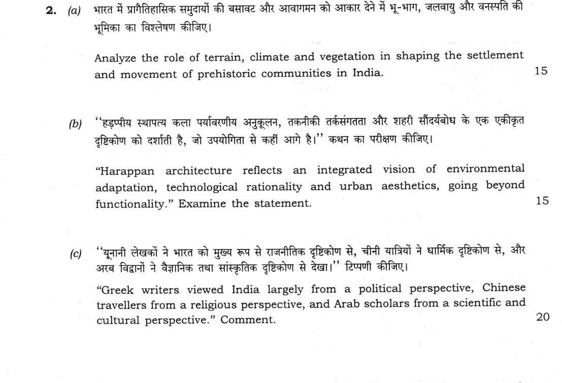
Analyze the role of terrain, climate and vegetation in shaping the settlement and movement of prehistoric communities in India. 15 marks
“Harappan architecture reflects an integrated vision of environmental adaptation, technological rationality and urban aesthetics, going beyond functionality.” Examine the statement. 15 marks
“Greek writers viewed India largely from a political perspective, Chinese travellers from a religious perspective, and Arab scholars from a scientific and cultural perspective.” Comment. 20 marks
हिंदी में प्रश्न पढ़ें
भारत में प्रागैतिहासिक समुदायों की बसावट और आवागमन को आकार देने में भू-भाग, जलवायु और वनस्पति की भूमिका का विश्लेषण कीजिए। (15 अंक)
‘‘हड़प्पीय स्थापत्य कला पर्यावरणीय अनुकूलन, तकनीकी तर्कसंगतता और शहरी सौंदर्यबोध के एक एकीकृत दृष्टिकोण को दर्शाती है, जो उपयोगिता से कहीं आगे है।’’ कथन का परीक्षण कीजिए। (15 अंक)
‘‘यूनानी लेखकों ने भारत को मुख्य रूप से राजनीतिक दृष्टिकोण से, चीनी यात्रियों ने धार्मिक दृष्टिकोण से, और अरब विद्वानों ने वैज्ञानिक तथा सांस्कृतिक दृष्टिकोण से देखा।’’ टिप्पणी कीजिए। (20 अंक)
Model answer
Drafted with AI by UPSC Answer Check against this question's marking rubric, to the expected length. UPSC does not publish answers for Mains — this is one way to score well, not an official key. How we build rubrics and answers.
(a) Environment and prehistoric settlement Terrain, climate and vegetation created the subsistence niches within which prehistoric communities chose where to live and how far to move, though they did not dictate every choice.
Terrain fixed habitation and raw-material sources. The Narmada alluvium at Hathnora yielded the Narmada hominin fossil (Arun Sonakia, 1982) with Acheulian tools; at Attirampakkam near Chennai, beside the Kortallaiyar, local quartzite was worked into Acheulian tools whose early date (c. 1.5 million years) is still debated; and the Bhimbetka shelters (Raisen, MP) gave long-term protection. In the Hunsgi-Baichbal valleys, K. Paddayya showed Acheulian groups moving seasonally between stream-side camps and raw-material outcrops.
Climate set the rhythm of movement. The Pleistocene-Holocene transition brought wetter conditions, and Mesolithic hunters camped beside ox-bow lakes of the Ganga plain at Sarai Nahar Rai, Damdama and Mahadaha. In the cold Kashmir valley, Neolithic Burzahom's people dug pit dwellings.
Vegetation shaped the turn to food production. Wild rice in the Belan valley underlies Neolithic Koldihwa and Mahagara; the savanna uplands of the Deccan supported cattle herders whose pens left ash mounds at Utnur and Kupgal; and Daojali Hading (Assam), with shouldered celts, reflects north-eastern hill forests. Yet human agency mattered: at Bagor (Bhilwara), excavated by V. N. Misra, herder-foragers with domesticated sheep and goat later acquired copper through contact with Ahar farmers; environment channelled exchange but did not confine it.
(b) Harappan architecture: beyond functionality The statement largely holds, though "aesthetics" must be argued from planning and proportion rather than ornament.
Environmental adaptation: at Dholavira, R. S. Bisht uncovered stone-cut reservoirs fed by dammed channels of the seasonal Manhar and Mansar streams, suited to arid Kachchh. Mohenjo-daro, Michael Jansen's "water city", had some 700 wells and covered drains. Builders used local materials: stone at Dholavira, mud brick at Kalibangan, burnt brick at Mohenjo-daro.
Technological rationality: bricks in a 1:2:4 ratio laid in English bond; the Great Bath's double brick wall sealed with gypsum mortar and a layer of bitumen; corbelling rather than the true arch. J. M. Kenoyer and Gregory Possehl stress this standardisation across a vast area alongside regional variation.
Urban aesthetics: the division into citadel and lower town, Dholavira's tripartite plan (citadel, middle town, lower town) with a ceremonial ground and a ten-sign signboard at its north gate, and the monumental Great Bath suggest a civic and ritual vision expressed through order and axiality.
Qualification: there are no identifiable temples or palaces, and houses were plain and inward-facing. Wheeler's "Great Granary" is now often read as a great hall, and S. R. Rao's Lothal "dockyard" was contested by L. S. Leshnik as an irrigation reservoir. The integrated vision is real, but it lies in planning and standardisation, not decoration.
(c) Greek, Chinese and Arab perspectives The triad is a useful heuristic but needs qualification, since each group's testimony overlaps the others'.
Greek writers: Megasthenes' Indica, preserved in Arrian, Strabo and Diodorus, centres on the Mauryan state (Pataliputra, the king, the municipal and military boards), which supports the "political" label. But his seven "castes" do not match varna-jati, Strabo doubted his fabulous races, and the Periplus of the Erythraean Sea and Ptolemy's Geography are commercial and geographical, listing ports such as Barygaza and Muziris.
Chinese travellers came as Buddhist pilgrims seeking texts and holy places: Fa-hien (399-414) in the reign of Chandragupta II, Hiuen Tsang (629-645) under Harsha, studying at Nalanda under Shilabhadra, and I-tsing (671-695). Yet they give the best secular data: Fa-hien on revenue from royal land, mild punishments and the segregation of Chandalas; Hiuen Tsang on land revenue of one-sixth, Harsha's quinquennial distribution at Prayaga and Nalanda's admission tests. Their Buddhist bias must be allowed for.
Arab scholars: Al-Biruni's Kitab-ul-Hind (Tahqiq-i-Hind, c. 1030), written after learning Sanskrit and reading Brahmagupta's Brahmasphutasiddhanta, is comparative and scientific, covering astronomy, mathematics, weights and measures and social custom. Sulaiman, Al-Masudi (Muruj-uz-Zahab) and Al-Idrisi describe trade, ports and geography. But Al-Biruni relied on brahmanical texts and informants and says little on contemporary politics.
Each group thus had a dominant lens, but the accounts overlap and must be used critically and together.
How this answer will be evaluated
Evaluation rubric
Each sub-part is marked on its own, against the marks and word limit printed on the paper.
- (a) 'Analyze' requires breaking the physical environment into its three named components - terrain (relief, river valleys, rock shelters, raw-material sources), climate (Pleistocene glacial-interglacial cycles, Holocene optimum, aridity) and vegetation (forest, savanna grassland, wild cereals) - and showing, with named prehistoric sites, how each shaped where communities settled and how and when they moved. 15 marks
Must cover
- Bhimbetka (Raisen, MP)
- Attirampakkam (Tamil Nadu)
- Hathnora, Narmada valley
- Hunsgi-Baichbal and K. Paddayya
- Sarai Nahar Rai / Damdama / Mahadaha
- Bagor (Bhilwara) and V. N. Misra
- Burzahom pit dwellings
- Utnur / Kupgal ash mounds
- Koldihwa-Mahagara, Belan valley
- Daojali Hading (Assam)
Loses marks
- Writing a general geography essay with no prehistoric site named - the marks lie in tying each environmental factor to specific excavated sites.
- Crude environmental determinism ('climate caused everything') without noting human agency and technological choice.
- Mixing up cultural stages: calling Bagor Neolithic, Burzahom Mesolithic, or Bhimbetka a Harappan site.
- Spending the whole answer on the Palaeolithic and ignoring the Mesolithic-Neolithic transition, which is where climate arguments are strongest.
- Quoting absolute dates (e.g. Attirampakkam at 1.5 million years) as settled when the chronology is still debated.
Earns more
- Vegetation defines subsistence niches: wild rice in the Belan valley leading to Neolithic Koldihwa and Mahagara; the semi-arid savanna of the Deccan granite uplands supporting cattle pastoralism evidenced by ash mounds at Utnur, Kupgal and Budihal; forest-savanna mosaic of central India sustaining foraging and the Bhimbetka rock art.
- Regionally specific adaptations: pit dwellings, bone tools and a dog-with-human burial at Burzahom (Srinagar) as a response to the Kashmir cold; Chirand (Saran, Bihar) and Lahuradewa (UP) in the humid Ganga plain; shouldered celts and cord-marked pottery at Daojali Hading (Dima Hasao, Assam) reflecting north-eastern hill ecology and South-East Asian links.
- Movement and contact: seasonal mobility between uplands and valleys (K. Paddayya's Hunsgi settlement model); Bagor (Bhilwara, Rajasthan), excavated by V. N. Misra, where Phase I microliths with early domesticated sheep/goat are followed by copper objects showing contact with Ahar Chalcolithic farmers - environment channelled, but did not prevent, inter-cultural exchange.
- (b) 'Examine' the claim that Harappan architecture was an integrated expression of three things - environmental adaptation, technological rationality and urban aesthetics - and not merely functional. The answer must test each of the three limbs with evidence, and also weigh the counter-argument that much Harappan building was plain, utilitarian and, in the case of Mohenjo-daro's 'granary' and Lothal's 'dock', disputed in interpretation. 15 marks
Must cover
- Brick ratio 1:2:4, English bond
- Great Bath: bitumen/gypsum waterproofing, double wall
- Dholavira reservoirs, Manhar and Mansar, R. S. Bisht, signboard of ten signs
- Mohenjo-daro wells (c. 700), covered drains
- Citadel/lower town division
- Lothal dockyard - S. R. Rao vs L. S. Leshnik (disputed)
- Wheeler's 'Great Granary' re-read as a great hall (disputed)
- Michael Jansen 'water city'; J. M. Kenoyer; Gregory Possehl
- Absence of true arch (corbelling used)
Loses marks
- Listing drainage and brick sizes only, and never addressing 'aesthetics' or 'integrated vision', which is what the statement asks about.
- Asserting the 'Great Granary' and the Lothal 'dockyard' as settled facts instead of flagging the debate.
- Claiming the Harappans used the true arch or the keystone - they used corbelling.
- Treating all Harappan cities as identical and missing regional building materials (stone at Dholavira, mud brick at Kalibangan).
- Giving no site-specific example for any of the three limbs of the statement.
Earns more
- Urban aesthetics and planned order: citadel and lower town; the Great Bath as monumental ritual architecture; Dholavira's tripartite plan (citadel, middle town, lower town) with a ceremonial ground and the ten-sign signboard, excavated by R. S. Bisht; gateways, proportion and axiality rather than applied ornament.
- Critical qualification: no identifiable temples or palaces and little monumental sculpture; houses plain and inward-facing; Mortimer Wheeler's 'Great Granary' at Mohenjo-daro is now usually read as a great hall, and S. R. Rao's Lothal 'dockyard' was contested by L. S. Leshnik as an irrigation tank/reservoir - the aesthetic claim must therefore be argued from planning, not decoration.
- Historiographical framing: Michael Jansen's reading of Mohenjo-daro as a 'water city' whose plan is organised around wells and drains; J. M. Kenoyer and Gregory Possehl on standardisation and regional variation (stone masonry at Dholavira, mud brick at Kalibangan, burnt brick at Mohenjo-daro) showing adaptation rather than a single template.
- (c) 'Comment' on a three-part generalisation about foreign accounts of India: that Greek writers saw India politically, Chinese pilgrims religiously and Arab scholars scientifically/culturally. The answer must test each limb with named authors and works, show what each genuinely contributes, and then qualify the neat triad by showing overlaps and exceptions. 20 marks
Must cover
- Megasthenes, Indica; Arrian, Strabo, Diodorus
- Periplus of the Erythraean Sea; Ptolemy's Geography
- Fa-hien (399-414), Fo-kuo-ki; Chandragupta II
- Hiuen Tsang (629-645), Si-yu-ki; Harsha; Shilabhadra; Nalanda
- I-tsing (671-695)
- Al-Biruni, Kitab-ul-Hind/Tahqiq-i-Hind, c. 1030
- Al-Masudi, Muruj-uz-Zahab; Sulaiman; Al-Idrisi
- One-sixth land revenue; Chandalas; Prayaga assembly
Loses marks
- Merely listing travellers and dates without addressing whether the political/religious/scientific classification holds.
- Getting the dates or patrons wrong - e.g. placing Fa-hien under Harsha or Hiuen Tsang under Chandragupta II.
- Calling Megasthenes' seven divisions 'castes' without noting the mismatch with the varna-jati system.
- Including Ibn Battuta (14th century, Rihla, Delhi Sultanate) as if he were an ancient Arab scientific writer without saying so.
- Offering no critical evaluation of reliability, which is precisely what 'comment' demands.
Earns more
- But the Greek limb is not uniform: the anonymous Periplus of the Erythraean Sea (c. 1st century CE) and Ptolemy's Geography are commercial-geographical, listing ports such as Barygaza, Muziris and Poduke; and Megasthenes' account of fabulous races was distrusted in antiquity (Strabo, Pliny), so his testimony must be used critically.
- But the Chinese accounts are also our best evidence on secular matters: land revenue of about one-sixth, the condition of the Chandalas (Fa-hien), rest houses, roads and law and order, Harsha's quinquennial distribution at Prayaga and the curriculum and admission debates of Nalanda (Hiuen Tsang) - their Buddhist bias must be allowed for, especially on royal patronage.
- Arab and Persian: Al-Biruni's Kitab-ul-Hind (c. 1030 CE), written after learning Sanskrit and reading the Puranas, Patanjali and Brahmagupta's Brahmasphutasiddhanta, deliberately comparative and interested in astronomy, mathematics, weights and measures, philosophy and social custom; with Sulaiman, Al-Masudi (Muruj-uz-Zahab) and Al-Idrisi on trade, ports and geography. Limits: he depends on brahmanical texts and informants and is largely silent on contemporary politics.
What "Analyse" is asking you to do
Break the subject into its working parts and show how they act on each other. The marks are in the interconnections — which factor drives which, and what the resulting structure explains — not in the inventory of factors.
Structure that answers it
Define the whole → separate it into its parts → show which part drives which → what that interaction produces → what the structure implies
Where marks are lost
A flat list of causes with no account of which drives which. An answer of neatly separated headings, each self-contained, scores as description.
Practice this exact question
Write your answer and it is marked point by point against the model answer above — what you covered, what you missed, what you got wrong.
Evaluate my answer →More from History 2026 Paper I
- Q1 Identify the following places marked on the map supplied to you and write a short note of…
- Q2 (a) Analyze the role of terrain, climate and vegetation in shaping the settlement and mov…
- Q3 (a) “The Iranian and Macedonian invasions reshaped ancient India through administrative i…
- Q4 (a) “Hoysala temple architecture marks a distinctive and innovative phase in the evolutio…
- Q5 Answer the following questions in about 150 words each : (a) How far can the Qutub Comple…