Paper II — Q3
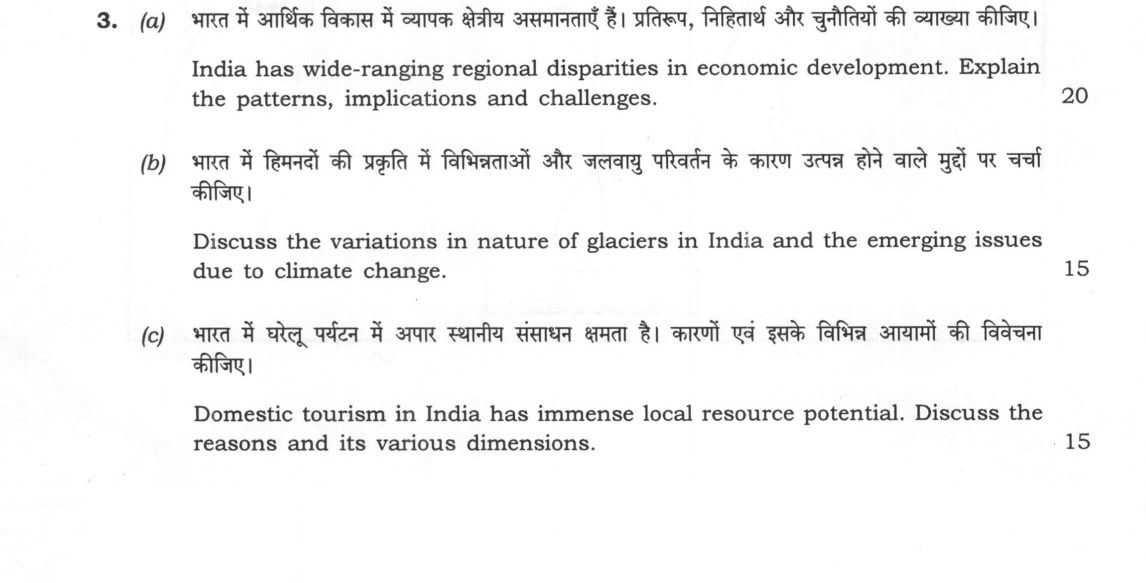
(a) India has wide-ranging regional disparities in economic development. Explain the patterns, implications and challenges. (20…
India has wide-ranging regional disparities in economic development. Explain the patterns, implications and challenges. 20 marks
Discuss the variations in nature of glaciers in India and the emerging issues due to climate change. 15 marks
Domestic tourism in India has immense local resource potential. Discuss the reasons and its various dimensions. 15 marks
हिंदी में प्रश्न पढ़ें
भारत में आर्थिक विकास में व्यापक क्षेत्रीय असमानताएँ हैं। प्रतिरूप, निहितार्थ और चुनौतियों की व्याख्या कीजिए। (20 अंक)
भारत में हिमनदों की प्रकृति में विभिन्नताओं और जलवायु परिवर्तन के कारण उत्पन्न होने वाले मुद्दों पर चर्चा कीजिए। (15 अंक)
भारत में घरेलू पर्यटन में अपार स्थानीय संसाधन क्षमता है। कारणों एवं इसके विभिन्न आयामों की विवेचना कीजिए। (15 अंक)
Model answer
Written by UPSC Answer Check against this question's marking rubric, to the expected length. UPSC does not publish answers for Mains — this is one way to score well, not an official key.
India’s economic geography exhibits persistent divergence, reflected in a high Williamson index of inter-state inequality. Pronounced per capita income gradients divide the industrialized western and southern corridors from the agrarian eastern and central hinterlands. This pattern arises from structural infrastructure gaps, unequal private capital flows, and stark Human Development Index disparities. Causal implications include distress inter-state migration, weakened social cohesion, and strains on national integration. Moreover, these disparities generate federal fiscal imbalances in Finance Commission redistributions, complicating the challenge of inclusive growth. Targeted policy frameworks like the Aspirational Districts Programme attempt to correct these imbalances through localized, convergence-based development.
Variations in Glaciers and Climate Vulnerabilities
India’s cryosphere exhibits marked morphological and microclimatic variations. The Greater Himalayan glaciers are primarily monsoon-influenced, high-relief valley and alpine types, whereas the Trans-Himalayan glaciers of Ladakh and the Karakoram occupy high-altitude cold deserts. Morphologically, they range from clean-ice glaciers at upper elevations to heavily debris-covered ablation zones in the mid-altitudes, alongside anomalous surge-type glaciers in the Karakoram. Climate warming drives accelerated mass loss and snout retreat, altering the seasonal hydrological regimes of the Indus, Ganga, and Brahmaputra basins. The formation of moraine-dammed proglacial lakes drastically heightens the risk of Glacial Lake Outburst Floods (GLOFs), such as the South Lhonak event. The National Action Plan on Climate Change (NAPCC), through the National Mission for Sustaining the Himalayan Ecosystem, monitors these cryospheric shifts to manage downstream ecological and hydrological vulnerabilities.
Domestic Tourism and Local Resource Potential
Domestic tourism harnesses dispersed local endowments, propelled by a growing middle class, expanding disposable incomes, improved transport connectivity, and the formalization of thematic and spiritual circuits under the Swadesh Darshan and Dekho Apna Desh initiatives. Its economic dimension generates high local employment multipliers and revitalizes backward rural economies. Socially, it enhances urban-rural linkages and regional cultural exchange. However, its environmental dimension poses acute challenges when tourist inflows exceed local carrying capacities, causing land degradation and resource depletion.
Integrated Way Forward
These spatial phenomena are deeply interconnected: economically lagging mountain and peripheral regions rely on domestic tourism to drive regional development, yet uncontrolled commercialization exacerbates climate and cryospheric vulnerability in fragile glacial valleys. Sustainable regional planning must align the diversification of backward district economies with strict ecological carrying-capacity limits and climate-resilient infrastructure frameworks.
What "Explain" is asking you to do
Make the working of something clear — what sets it off, what follows from what, and what it produces. Explain is the Commission's mechanism word: it dominates the technical papers and the “explain why” stems, where the marks sit in the causal chain and not in the label.
Structure that answers it
State what it is → the initiating condition → the chain of cause, step by step → an instance where it plays out → what the chain produces
Where marks are lost
Describing what something looks like instead of why it works that way. Naming the stages without linking them reads as description too.
How this answer will be evaluated
Approach
Framework: Concept > Diagram > Regional Example > Application. (a) explain: definition/context > points in order > small example > short close | (b) discuss: intro > 3-4 dimensions > example > balanced close | (c) discuss: intro > 3-4 dimensions > example > balanced close Full marks: Comprehensive, well-structured, with specific examples and diagrams.
Key points expected
- Define regional disparity in economic development
- Explain patterns (e.g., North-South, Coastal-Inland)
- Discuss implications (migration, inequality, political tension)
- Identify challenges (infrastructure, policy, resource distribution)
- Describe variations in glacier nature (e.g., Himalayan vs. Karakoram)
- Explain impact of climate change on glaciers
- Identify emerging issues (e.g., GLOFs, water security)
- Link physical changes to human consequences
Evaluation rubric
Each sub-part is marked on its own, against the marks and word limit printed on the paper.
- (a) Patterns, implications, and challenges of regional disparities in economic development. 20 marks
explain— definition/context → points in order → small example → short close
Must cover
- Define regional disparity in economic development
- Explain patterns (e.g., North-South, Coastal-Inland)
- Discuss implications (migration, inequality, political tension)
- Identify challenges (infrastructure, policy, resource distribution)
Loses marks
- Listing states without explaining the disparity
- Ignoring the 'implications' aspect
- Vague generalizations without specific examples
Earns more
- Reference to specific indices (e.g., HDI, GSDP)
- Mention of specific states (e.g., Kerala vs. Bihar)
- Discussion of government schemes (e.g., NEP, GAD)
- Linkage to physical geography (terrain, climate)
Extra mark
- Labelled map showing disparity zones
- Recent data on regional GDP growth
- (b) Variations in nature of glaciers in India and emerging issues due to climate change. 15 marks
discuss— intro → 3-4 dimensions → example → balanced close
Must cover
- Describe variations in glacier nature (e.g., Himalayan vs. Karakoram)
- Explain impact of climate change on glaciers
- Identify emerging issues (e.g., GLOFs, water security)
- Link physical changes to human consequences
Loses marks
- Focusing only on one region
- Ignoring the 'emerging issues' aspect
- No link to climate change
Earns more
- Mention of specific glaciers (e.g., Gangotri, Siachen)
- Discussion of GLOF mechanisms
- Reference to recent glacial lake outbursts
- Impact on downstream river systems
Extra mark
- Diagram of GLOF process
- Data on glacial retreat rates
- (c) Reasons for immense local resource potential and various dimensions of domestic tourism in India. 15 marks
discuss— intro → 3-4 dimensions → example → balanced close
Must cover
- Explain reasons for local resource potential
- Discuss various dimensions of domestic tourism
- Link local resources to tourism development
- Provide specific examples of local resources
Loses marks
- Ignoring the 'local resource' aspect
- Vague discussion of 'dimensions'
- No specific examples
Earns more
- Mention of specific local resources (e.g., handicrafts, cuisine)
- Discussion of cultural and natural dimensions
- Reference to specific tourist destinations
- Impact on local economies
Extra mark
- Map of key domestic tourism circuits
- Data on domestic tourist numbers
Practice this exact question
Write your answer and it is marked point by point against the model answer above — what you covered, what you missed, what you got wrong.
Evaluate my answer →More from Geography 2024 Paper II
- Q1 On the outline map of India provided to you, mark the location of all of the following. W…
- Q2 (a) Institutional factors are playing a dominant role in controlling the agricultural pro…
- Q3 (a) India has wide-ranging regional disparities in economic development. Explain the patt…
- Q4 (a) Migration is the reflection of regional disparities. What socio-economic and demograp…
- Q5 Answer the following questions in about 150 words each: (a) How are geographic factors in…
- Q6 (a) Industrial waste is diversified. Discuss the potentials and challenges associated wit…