Paper I — Q6
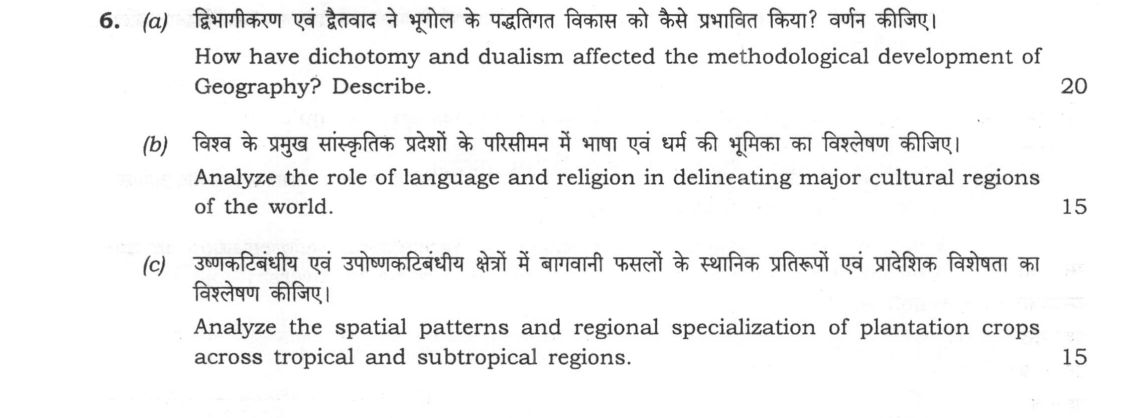
(a) How have dichotomy and dualism affected the methodological development of Geography? Describe. (20 marks) (b) Analyze the…
How have dichotomy and dualism affected the methodological development of Geography? Describe. 20 marks
Analyze the role of language and religion in delineating major cultural regions of the world. 15 marks
Analyze the spatial patterns and regional specialization of plantation crops across tropical and subtropical regions. 15 marks
हिंदी में प्रश्न पढ़ें
क्षेत्रीकरण एवं द्वैतवाद ने भूगोल के पद्धतिगत विकास को कैसे प्रभावित किया? वर्णन कीजिए। (20 अंक)
विश्व के प्रमुख सांस्कृतिक प्रदेशों के परिसीमन में भाषा एवं धर्म की भूमिका का विस्लेषण कीजिए। (15 अंक)
उष्णकटिबंधीय एवं उपोष्णकटिबंधीय क्षेत्रों में बागवानी फसलों के स्थानिक प्रतिरूपों एवं प्रादेशिक विशेषता का विस्लेषण कीजिए। (15 अंक)
Model answer
Written by UPSC Answer Check against this question's marking rubric, to the expected length. UPSC does not publish answers for Mains — this is one way to score well, not an official key.
Dichotomy and Dualism in Methodological Development
Dichotomy and dualism have historically driven the methodological progression of geography. Dichotomy represents the structural bifurcation of the discipline into distinct empirical domains—primarily physical geography (earth sciences) versus human geography (social sciences). Dualism, by contrast, denotes competing philosophical and epistemological stances regarding how geographical knowledge should be generated.
Bernhard Varenius formalized this division in the seventeenth century by separating Geographia Generalis (systematic and universal laws of physical geography) from Geographia Specialis (descriptive, human-centric regional studies). In the nineteenth and early twentieth centuries, dualism manifested prominently as Environmental Determinism (Friedrich Ratzel, Ellen Churchill Semple), which positioned physical environments as the primary controllers of human action, versus Possibilism (Paul Vidal de la Blache, Lucien Febvre), which emphasized human agency and choice within environmental limits.
Methodological tensions deepened through the debate between idiographic approaches (areal differentiation, championed by Alfred Hettner and formalized by Richard Hartshorne in The Nature of Geography) and nomothetic approaches (the search for universal spatial laws). Hartshorne viewed geography as a chorological science focused on unique regions. Fred K. Schaefer challenged this exceptionalism, catalyzing the Quantitative Revolution of the 1950s and 1960s and transforming geography into a nomothetic spatial science reliant on geometry, statistical modeling, and locational analysis.
The resulting mechanistic reductionism provoked further dualisms, inspiring humanistic geography (emphasizing lived experience and place), radical/Marxist geography (focusing on uneven development), and behavioral approaches. Ultimately, these successive intellectual dialectics led modern geography toward a post-modern synthesis and integrated regional geography, reconciling quantitative spatial analysis with qualitative social theory.
Language and Religion in Delineating Cultural Realms
Language and religion serve as fundamental cultural markers that delineate distinct cultural realms across global space. Major language families establish linguistic boundaries and structural worldviews: the Indo-European family defines broad territories across Europe, the Americas, and South Asia; Sino-Tibetan shapes East Asia; and Afro-Asiatic unifies North Africa and Southwest Asia.
Concurrently, religious distributions structure macro-cultural realms. The Islamic Crescent spans the Middle East, North Africa, and Central Asia, creating shared legal, spatial, and institutional landscapes. The Indic Realm is anchored in Hindu traditions and philosophy within India, while the East Asian Realm reflects the syncretic confluence of Confucianism, Taoism, and Mahayana Buddhism. The Occidental Realm across Europe, the Americas, and Australasia is shaped by diverse branches of Christianity.
These regional delineations are rarely absolute. They feature extensive transition zones and syncretic belts, such as Southeast Asia, which blends Indic, Sinic, and Islamic influences, and the African Sahel, where Arabic-Islamic traditions meet Sub-Saharan cultures. Furthermore, historical colonialism, the transatlantic slave trade, and modern globalization have introduced profound linguistic and religious pluralism, creating complex, overlapping cultural enclaves that challenge rigid cartographic boundaries.
Spatial Patterns and Specialization in Plantation Agriculture
Plantation agriculture in tropical and subtropical regions displays intense spatial clustering, governed by specific agro-climatic requirements, historical colonial investments, and access to global trade corridors. Prominent regional specializations include natural rubber in Southeast Asia (Thailand, Indonesia) and Kerala; tea in the humid uplands of Assam, Sri Lanka, and Kenya; coffee in Brazil’s fazendas and southern India (Karnataka); cocoa across the equatorial belt of West Africa (Côte d'Ivoire, Ghana); sugarcane in the Caribbean, Cuba, and Brazil; and oil palm concentrated in Malaysia and Indonesia.
Spatially, plantation systems reflect modified Von Thünen principles: capital-intensive, monocultural estates located in tropical hinterlands but oriented entirely toward maritime export routes rather than domestic urban consumption. This spatial architecture directly reflects historical Core-Periphery relationships established under European colonial mercantilism, which utilized indentured labor to extract raw commodities for industrializing metropoles.
In the contemporary era, while these agricultural enclaves remain vital foreign exchange earners, their spatial concentration generates acute sustainability challenges. These include extensive deforestation in the Sundaland and Amazon basins, rapid biodiversity loss, soil exhaustion from monoculture, and economic precarity driven by global commodity price volatility.
Synthesizing methodological evolution, cultural regionalization, and agrarian spatial patterns demonstrates geography’s transition from rigid descriptive dualisms toward an integrated spatial-ecological framework that evaluates the complex interactions between human culture, economic systems, and the physical environment.
What "Describe" is asking you to do
Give a full, ordered account of the thing named — its parts, stages or mechanism — in the sequence in which it actually exists or occurs. Most describe questions come from the science optionals, where the marks sit in correct technical detail and, where the stem says so, a labelled diagram.
Structure that answers it
One-line identification of the subject → the parts or stages in their real order, each with its defining detail → labelled diagram where the subject is structural → closing line on function or significance
Where marks are lost
Loose general prose where the examiner is ticking named parts, correct terminology and their sequence; and in the General Studies papers, turning to evaluation before the description is finished.
How this answer will be evaluated
Approach
(a) describe: define > structure or process in order > labelled diagram > significance | (b) analyse: intro > causes > effects > stakeholders/linkages > way forward | (c) analyse: intro > causes > effects > stakeholders/linkages > way forward Full marks: Comprehensive, well-structured, with diagrams and specific examples.
Key points expected
- Define dichotomy and dualism in geographical context
- Explain the physical-human geography split
- Describe the shift towards integration
- Include a diagram of methodological evolution
- Define cultural region and its boundaries
- Analyze language as a primary delineator
- Analyze religion as a primary delineator
- Provide specific regional examples
Evaluation rubric
Each sub-part is marked on its own, against the marks and word limit printed on the paper.
- (a) Define dichotomy/dualism and trace their impact on geographical methodology. 20 marks
describe— define → structure or process in order → labelled diagram → significance
Must cover
- Define dichotomy and dualism in geographical context
- Explain the physical-human geography split
- Describe the shift towards integration
- Include a diagram of methodological evolution
Loses marks
- Describing history without methodological focus
- Confusing dichotomy with simple classification
- Omitting the integration phase
Earns more
- Mention specific thinkers like Ratzel or Hartshorne
- Discuss the role of quantitative revolution
- Reference the 'crisis of geography' period
- Link to modern GIS and spatial analysis
Extra mark
- Cite a specific methodological paper or book
- Provide a timeline of methodological shifts
- (b) Analyze how language and religion define major cultural regions. 15 marks
analyse— intro → causes → effects → stakeholders/linkages → way forward
Must cover
- Define cultural region and its boundaries
- Analyze language as a primary delineator
- Analyze religion as a primary delineator
- Provide specific regional examples
Loses marks
- Listing regions without analyzing the role of factors
- Ignoring the interaction between language and religion
- Vague examples without specific regions
Earns more
- Discuss the role of language families
- Mention specific religious regions (e.g., Islamic world)
- Note the overlap or conflict of these factors
- Reference specific cultural boundaries
Extra mark
- Include a map of major cultural regions
- Cite a specific linguistic or religious study
- (c) Analyze spatial patterns and regional specialization of plantation crops. 15 marks
analyse— intro → causes → effects → stakeholders/linkages → way forward
Must cover
- Define plantation crops and their characteristics
- Analyze spatial patterns in tropical regions
- Analyze spatial patterns in subtropical regions
- Explain regional specialization factors
Loses marks
- Describing crops without spatial analysis
- Ignoring the distinction between tropical and subtropical
- Failing to explain the causes of specialization
Earns more
- Mention specific crops and their primary regions
- Discuss climatic and soil requirements
- Reference historical colonial influences
- Note modern shifts in production areas
Extra mark
- Include a map of plantation crop distribution
- Cite specific production statistics or data
Practice this exact question
Write your answer and it is marked point by point against the model answer above — what you covered, what you missed, what you got wrong.
Evaluate my answer →More from Geography 2025 Paper I
- Q3 (a) Examine the formation of atmospheric tricellular circulation system. Describe with ex…
- Q4 (a) What are the ecological consequences of agricultural deforestation in the Amazon and…
- Q5 Answer the following in about 150 words each: (a) Why did the Welfare Approach in Human G…
- Q6 (a) How have dichotomy and dualism affected the methodological development of Geography?…
- Q7 (a) Why is oil important for energy security? What is the role of oil in clean energy tra…
- Q8 (a) Why has F. Perroux's theory of growth pole as a model of regional growth been critici…