Paper I — Q7
(a) What are the main concerns of radical geography ? Describe the salient features and objectives of radicalism in geography…
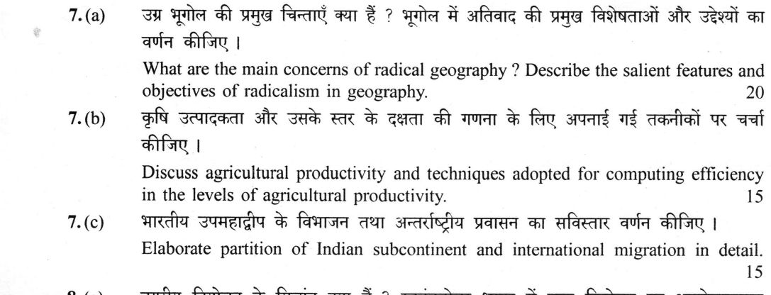
What are the main concerns of radical geography ? Describe the salient features and objectives of radicalism in geography. 20 marks
Discuss agricultural productivity and techniques adopted for computing efficiency in the levels of agricultural productivity. 15 marks
Elaborate partition of Indian subcontinent and international migration in detail. 15 marks
हिंदी में प्रश्न पढ़ें
आमूल (रेडिकल) भूगोल की प्रमुख चिन्ताएँ क्या हैं ? भूगोल में आमूलवाद की प्रमुख विशेषताओं और उद्देश्यों का वर्णन कीजिए । (20 अंक)
कृषि उत्पादकता और उसके स्तर के दक्षता की गणना के लिए अपनाई गई तकनीकों पर चर्चा कीजिए । (15 अंक)
भारतीय उपमहाद्वीप के विभाजन तथा अन्तर्राष्ट्रीय प्रवासन का सविस्तार वर्णन कीजिए । (15 अंक)
Model answer
Drafted with AI by UPSC Answer Check against this question's marking rubric, to the expected length. UPSC does not publish answers for Mains — this is one way to score well, not an official key. How we build rubrics and answers.
(a) Radical geography
Radical geography emerged in the late 1960s as a structural critique of the prevailing positivist and quantitative paradigms. Its main concerns are substantive, focusing on the spatial dimensions of poverty, racism, the urban ghetto, imperialism, and uneven development. It argues that these are not accidental outcomes but results of the internal logic of the capitalist mode of production.
The salient features of radicalism are methodological. It employs Marxist political economy and historical materialism to explain spatial patterns. A central tenet is the concept of "space as socially produced," drawing on Lefebvre and later Soja, which rejects the view of space as a neutral container. It utilizes structural explanation to replace mere spatial correlation and rejects "spatial fetishism." The movement is anchored in the journal Antipode (founded 1969) and the works of scholars such as David Harvey (Social Justice and the City, 1973), William Bunge (Detroit Geographical Expedition), Richard Peet (Radical Geography, 1977), Neil Smith (Uneven Development, 1984) and Doreen Massey (Spatial Divisions of Labour, 1984); it also recovered the anarchist geographers Peter Kropotkin (What Geography Ought to Be, 1885) and Élisée Reclus.
The objectives of radical geography are normative. It seeks social justice and structural change, aiming to "change the world, not merely describe it." It emphasizes "praxis," linking academic research to political activism. While it has influenced critical and feminist geography, it has faced criticism for economic determinism, jargon, and a sometimes thin empirical base.
(b) Measuring agricultural productivity
Agricultural productivity is defined as the ratio of output to input, distinct from production (total volume), intensity (frequency of cropping), or efficiency (technical performance). Computing these levels requires specific techniques to ensure comparability across regions.
The most common techniques include:
- M. G. Kendall’s Ranking Coefficient Method (1939): This method ranks each areal unit according to its per-hectare yield of each crop. The mean of these ranks is calculated; the lowest value indicates the highest productivity.
- Gyorgy Enyedi’s Crop Productivity Index (1964): This uses a weighted average of crop yields to create a composite index.
- Mohammad Shafi’s Productivity Index (1972): This compares a unit's output of the principal crops, combined through their shares of cropped area, with the regional level.
- Sapre and Deshpande (1964) and S. S. Bhatia (1967): These weighted yield-index methods measure agricultural efficiency across districts, Bhatia weighting crop yield indices by the share of cropped area.
- W. Y. Yang’s Crop Yield Index (1965): This focuses on the yield per unit area of specific crops.
- L. Dudley Stamp’s Standard Nutrition Unit (1958): This converts various food crops into a common calorie unit (one SNU is about one million calories a year, the need of an average person) to show how many people a hectare can feed.
- Total Factor Productivity (TFP): This measures the efficiency of all inputs (land, labor, capital) simultaneously, as opposed to partial factor productivity.
- Frontier Analysis: Methods like Data Envelopment Analysis (DEA) and stochastic frontier analysis are used to separate technical efficiency from allocative efficiency, and the yield gap compares actual with attainable yield.
Caveats in these techniques include the "modifiable areal unit problem" (MAUP), where results change based on the size of the administrative unit used. Additionally, rank methods lose the magnitude of differences, and calorie-based indices may undervalue commercial crops.
(c) Partition and international migration
The partition of the Indian subcontinent, formalized by the Indian Independence Act of 1947 and the Mountbatten Plan (3 June 1947), resulted in the most massive international migration in history. The Radcliffe Line, published on 17 August 1947, divided Punjab and Bengal based on district-wise religious majorities.
The resulting displacement was staggering, with an estimated 14–18 million people moving across the new borders. The character of migration differed significantly: in Punjab, it was a rapid, complete "swap" of populations, whereas in Bengal, it was a slower, more complex trickle. The death toll remains disputed, ranging from 200,000 to 2 million. This act of partition set the stage for later flows, most notably the 1971 Bangladesh Liberation War, which sent approximately 10 million refugees into India, fundamentally altering the demographics of states like Tripura and Assam. In the west, Muhajirs settled in Karachi and Sindh, Sindhi Hindus moved to Gujarat and Maharashtra, and the Nehru–Liaquat Pact (1950) sought to protect minorities and stem the continuing eastern flow. The 1971 flows shaped the Assam Accord (1985), whose 25 March 1971 cut-off underlies the updated NRC in Assam (2019), and later the Citizenship (Amendment) Act, 2019; the Land Boundary Agreement (1974, implemented 2015) settled the enclaves.
The "rehabilitation geography" of this migration is distinct. Refugee townships such as Faridabad, Nilokheri, and Ulhasnagar were created to house the displaced. The Dandakaranya Development Project and the Marichjhapi incident (1979) are examples of the state's attempt to manage this settlement. The long-term consequences include the securitization of borders, the Indus Waters Treaty (1960; held in abeyance by India since April 2025), and the emergence of a massive South Asian diaspora. Today India is the largest source of international migrants (about 18 million, UN DESA) and the largest recipient of remittances (about US$129 billion in 2024, World Bank); this diaspora is driven mainly by later labour and skilled migration, but partition set the first great international flows of modern South Asia.
How this answer will be evaluated
Evaluation rubric
Each sub-part is marked on its own, against the marks and word limit printed on the paper.
- (a) Three tasks: state the main concerns of radical geography, describe its salient features, and state its objectives. The concerns are substantive (poverty, racism, ghetto, imperialism, uneven development); the features are methodological (Marxist political economy, space as socially produced, rejection of positivism, praxis); the objectives are normative (social justice, structural change, relevance). Names and works are expected throughout. 20 marks
Must cover
- Antipode, founded at Clark University in 1969
- David Harvey, 'Social Justice and the City' (1973); 'The Limits to Capital' (1982)
- William Bunge, Detroit Geographical Expedition and Institute; 'Fitzgerald: Geography of a Revolution' (1971)
- Richard Peet, 'Radical Geography' (1977); Neil Smith, 'Uneven Development' (1984) and the rent gap (1979); Doreen Massey, 'Spatial Divisions of Labour' (1984)
- Peter Kropotkin, 'What Geography Ought to Be' (1885); Elisee Reclus
- Marxist political economy; space as socially produced (Lefebvre; Soja, 'Postmodern Geographies', 1989)
- Rejection of positivism and spatial fetishism; the relevance debate; praxis
Loses marks
- Confusing radical geography with behavioural or humanistic geography, which arose in the same years but from a phenomenological, not a Marxist, critique of positivism
- Naming no scholar and no journal, so the answer has no anchor -- Harvey, Bunge, Peet and Antipode are the minimum the examiner expects
- Answering only the 'concerns' and neglecting the features and objectives that the second sentence of the question demands
- Dating the movement wrongly -- placing it in the 1950s or the 1990s rather than around 1969-70
- Treating radicalism as merely 'concern for the poor' without the structural, political-economy content that distinguishes it from welfare geography
- Offering no criticism at all, which weakens an otherwise complete answer
Earns more
- Describes the salient features: Marxist historical-materialist political economy; space as socially produced rather than a neutral container (Lefebvre, later Soja); structural explanation replacing spatial correlation; an avowedly normative stance against value-free science; and commitment to praxis linking research to activism
- States the objectives and assesses the legacy: exposing structural causes, social relevance, changing and not merely describing the world, democratising knowledge; legacy in critical, feminist, postcolonial and welfare geography and political ecology; criticisms of economic determinism, jargon, thin empiricism and neglect of agency
- (b) Two tasks: discuss what agricultural productivity means and how it differs from related ideas, and then set out the techniques used to compute and compare levels of productivity and efficiency. The second is the weightier half and must give named methods with their authors and, where possible, the form of the index. 15 marks
Must cover
- Productivity as output per unit of input; distinction from production, intensity and efficiency
- M. G. Kendall's ranking coefficient method (1939) -- mean of crop-wise ranks, lowest value highest productivity
- Gyorgy Enyedi's crop productivity index (1964); Mohammad Shafi's productivity index (1972); Sapre and Deshpande (1964); W. Y. Yang's crop yield index (1965); S. S. Bhatia (1967)
- L. Dudley Stamp's Standard Nutrition Unit (1958)
- Total factor productivity against partial factor productivity; Data Envelopment Analysis; stochastic frontier analysis; yield gap
- Modifiable areal unit problem; weighting and crop-set sensitivity
Loses marks
- Discussing the determinants of agricultural productivity -- irrigation, fertiliser, seeds, credit -- instead of the techniques for computing it, which is what the question asks
- Naming a method without stating what it actually does, so 'Kendall's method' appears with no explanation of ranking
- Confusing productivity with production, or with cropping intensity
- Misattributing the methods -- crediting the ranking coefficient to Enyedi or Shafi, or the Standard Nutrition Unit to Kendall
- Giving a garbled formula asserted with false precision; a correct statement of the logic in words is safer and is what the examiner rewards
- Omitting any mention of the limitations, although 'discuss' invites evaluation
Earns more
- Explains efficiency measurement proper: partial factor productivity against total factor productivity, index-number or growth-accounting computation, frontier methods (Data Envelopment Analysis, stochastic frontier analysis) separating technical from allocative efficiency, and the yield-gap benchmark of actual against attainable yield
- States the caveats: sensitivity to crop set and weighting, loss of magnitude in rank methods, calorie conversion undervaluing commercial crops, price distortion from support prices, the modifiable areal unit problem, and the inadequacy of land productivity where water or energy is the binding constraint (Punjab's yields against its groundwater draft)
- (c) 'Elaborate in detail' the partition of the Indian subcontinent AND international migration -- the two are to be connected, not treated separately. The answer must cover the act of partition itself, the scale, direction and character of the resulting cross-border movement, the later flows it set in train (1971 above all), the rehabilitation geography, and the enduring effect on citizenship, borders and the diaspora. 15 marks
Must cover
- Indian Independence Act 1947; Mountbatten Plan of 3 June 1947; Radcliffe Line, award published 17 August 1947
- Punjab and Bengal boundary commissions; district-wise religious-majority criterion
- Roughly 14-18 million displaced; death toll estimated between 200,000 and 2 million (disputed)
- Muhajirs of Karachi and Sindh; Sindhi Hindus in Gujarat and Maharashtra; Nehru-Liaquat Pact 1950
- 1971 Bangladesh liberation war and about 10 million refugees; Tripura's demographic transformation
- Assam Accord 1985 and the 25 March 1971 cut-off; IMDT Act 1983 struck down in 2005; NRC; CAA 2019
- Dandakaranya Development Project; Marichjhapi (1979); Faridabad, Nilokheri, Rajpura, Gandhidham, Ulhasnagar
- Indus Waters Treaty 1960; Land Boundary Agreement 1974, implemented 2015
Loses marks
- Writing a political history of the freedom movement and the demand for Pakistan instead of a geography of displacement, settlement and border-making
- Asserting a single precise figure for deaths or for displaced persons as though it were settled, when both are contested -- the safer and better answer states the range and calls it disputed
- Treating the Punjab and Bengal flows as identical, when their timing, completeness and direction differed fundamentally and the contrast is the most examinable point in the question
- Stopping in 1947 and ignoring 1971 and its long aftermath in Assam and Tripura, though these are the living international-migration consequences
- Omitting the rehabilitation and resettlement geography, which is the part of the answer that is distinctively geographical
- Confusing the Radcliffe Line with the Durand Line, the McMahon Line or the Line of Control
Earns more
- Covers the rehabilitation geography: refugee townships and colonies (Faridabad, Nilokheri, Rajpura, Lajpat Nagar, Gandhidham, Ulhasnagar), the Dandakaranya Development Project and Marichjhapi (1979), Andaman resettlement, and the abrupt reshaping of Delhi, Amritsar, Jalandhar and Kolkata
- States the long-run consequences for international migration and geopolitics: the Indus Waters Treaty 1960, the Kashmir dispute, fenced and securitised borders, and the emergence of a global South Asian diaspora with India now the largest source of international migrants (about 18 million, UN estimate for 2020) and the largest remittance recipient
What "Describe" is asking you to do
Give a full, ordered account of the thing named — its parts, stages or mechanism — in the sequence in which it actually exists or occurs. Most describe questions come from the science optionals, where the marks sit in correct technical detail and, where the stem says so, a labelled diagram.
Structure that answers it
One-line identification of the subject → the parts or stages in their real order, each with its defining detail → labelled diagram where the subject is structural → closing line on function or significance
Where marks are lost
Loose general prose where the examiner is ticking named parts, correct terminology and their sequence; and in the General Studies papers, turning to evaluation before the description is finished.
Practice this exact question
Write your answer and it is marked point by point against the model answer above — what you covered, what you missed, what you got wrong.
Evaluate my answer →More from Geography 2026 Paper I
- Q4 (a) How does the annual variations in temperature and precipitation influence plants grow…
- Q5 Answer the following in about 150 words each : (a) “Systematic Geography is essentially a…
- Q6 (a) Discuss the Geometry of Land Values in Urban Community and delimiting the Central Bus…
- Q7 (a) What are the main concerns of radical geography ? Describe the salient features and o…
- Q8 (a) What are the principles of urban planning ? Critically analyse town planning in India…