Paper I — Q5
(a) Discuss the conditions required for the preservation of soft parts of fossils. (10 marks) (b) Discuss the principles of…
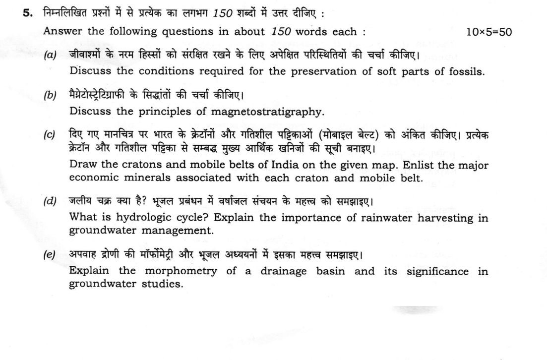
Answer the following questions in about 150 words each :
Discuss the conditions required for the preservation of soft parts of fossils. 10 marks
Discuss the principles of magnetostratigraphy. 10 marks
Draw the cratons and mobile belts of India on the given map. Enlist the major economic minerals associated with each craton and mobile belt. 10 marks
What is hydrologic cycle? Explain the importance of rainwater harvesting in groundwater management. 10 marks
Explain the morphometry of a drainage basin and its significance in groundwater studies. 10 marks
हिंदी में प्रश्न पढ़ें
निम्नलिखित प्रश्नों में से प्रत्येक का लाभग 150 शब्दों में उत्तर दीजिए :
जीवाश्मों के नरम हिस्सों को संरक्षित रखने के लिए अपेक्षित परिस्थितियों की चर्चा कीजिए। (10 अंक)
मैग्नेटोस्ट्रेटिग्राफी की सिद्धांतों की चर्चा कीजिए। (10 अंक)
दिए गए मानचित्र पर भारत के क्रेटॉनों और गतिशील पट्टिकाओं (मोबाइल बेल्ट) को अंकित कीजिए। प्रत्येक क्रेटॉन और गतिशील पट्टिका से सम्बद्ध मुख्य आर्थिक खनिजों की सूची बनाइए। (10 अंक)
जलीय चक्र क्या है? भूजल प्रबंधन में वर्षाजल संचयन के महत्व को समझाइए। (10 अंक)
अपवाह द्रोणी की मार्फोमेट्री और भूजल अध्ययनों में इसका महत्व समझाइए। (10 अंक)
Model answer
Drafted with AI by UPSC Answer Check against this question's marking rubric, to the 150-word length. UPSC does not publish answers for Mains — this is one way to score well, not an official key. How we build rubrics and answers.
(a) Preservation of soft parts of fossils (10 marks)
Soft, non-mineralised tissues normally rot or are eaten, so their preservation needs special conditions.
- Rapid burial in fine mud, silt or volcanic ash, which seals the body from scavengers and oxygen.
- Oxygen-poor (anoxic or euxinic) bottom water, which stops aerobic decay and prevents burrowing.
- Quiet, low-energy settings with no scavengers or bioturbation, and microbial mats that seal the surface.
- Early diagenetic mineralisation by phosphate, pyrite, silica or carbonate concretions, which replaces tissue before it decays.
- Special media that halt decay: amber (resin), permafrost, asphalt seeps, hypersaline or acidic waters, and desiccation.
Such deposits, called Konservat-Lagerstätten, include the Burgess Shale, Chengjiang, Solnhofen and Messel.
(b) Principles of magnetostratigraphy (10 marks)
- Recording: rocks record the Earth's magnetic field at their formation. Igneous rocks acquire thermoremanent magnetisation on cooling through the Curie temperature; sediments acquire detrital remanent magnetisation as magnetic grains align during deposition.
- Reversals: the geomagnetic field has reversed polarity many times at irregular intervals, and each reversal is geologically almost instantaneous and global, so it is an isochronous datum plane.
- Procedure: oriented samples are collected through a sequence; stepwise demagnetisation removes secondary overprints and leaves the characteristic remanent magnetisation, whose sign gives normal or reversed polarity.
- Polarity column: the polarity of each level is plotted as black and white zones (chrons).
- Correlation: the pattern is matched with the geomagnetic polarity time scale, using radiometric ages and fossils as anchors.
Applications include dating, global correlation and ocean-floor spreading rates.
(c) Cratons and mobile belts of India and their minerals (10 marks)

Cratons.
- Dharwar: gold (Kolar, Hutti), iron and manganese ores, chromite.
- Bastar: iron ore (Bailadila), tin, bauxite, limestone.
- Singhbhum: iron ore, copper, uranium (Jaduguda), gold, chromite.
- Bundelkhand: granite, pyrophyllite, diaspore.
- Aravalli: lead–zinc (Zawar), phosphate, marble, tungsten.
Mobile belts.
- Aravalli–Delhi: copper (Khetri), lead–zinc (Rampura-Agucha), talc.
- Central Indian Tectonic Zone: manganese and copper (Malanjkhand).
- Eastern Ghats: bauxite, graphite, sillimanite, beach-sand ilmenite.
- Southern Granulite: magnesite, corundum, beach-sand monazite.
- Himalaya: limestone, magnesite, gypsum.
(d) Hydrologic cycle and rainwater harvesting in groundwater management (10 marks)
Hydrologic cycle. It is the continuous circulation of water between ocean, atmosphere and land, driven by solar energy and gravity. Its components are evaporation and transpiration, condensation, precipitation, interception, infiltration, percolation, runoff and groundwater flow with base flow to streams. The water balance is P = E + R + ΔS.
Importance of rainwater harvesting. Harvesting recharges aquifers through check dams, percolation tanks, recharge pits and wells, and rooftop systems, so that the water table rises where groundwater is over-exploited. It reduces runoff, flood peaks and soil erosion, sustains base flow, and improves quality by diluting fluoride and salinity. In coastal areas recharge checks seawater intrusion, and the method is cheap and local.
(e) Morphometry of a drainage basin and its significance in groundwater studies (10 marks)
Morphometry is the quantitative measurement of basin shape and the drainage network.
- Linear: stream order (Strahler); bifurcation ratio Rb = Nu/Nu+1; stream length Lu.
- Areal: drainage density Dd = ΣL/A; stream frequency Fs = ΣN/A; form factor Rf = A/Lb²; circularity ratio Rc = 4πA/P²; elongation ratio Re = 2√(A/π)/Lb.
- Relief: basin relief H; relief ratio Rh = H/Lb; ruggedness number Rn = H·Dd; hypsometric integral.
Significance. High Dd, Fs and steep relief mean more runoff and less infiltration, that is, poor groundwater potential; low Dd, gentle slopes and permeable rocks favour infiltration and recharge. Elongated basins (low Rf, Rc) have a flatter flood peak than circular ones. With RS and GIS, these parameters rank watersheds for groundwater zonation and for the siting of recharge structures.
How this answer will be evaluated
Evaluation rubric
Each sub-part is marked on its own, against the marks and word limit printed on the paper.
- (a) Discuss the conditions required for the preservation of soft parts of fossils (10 marks; about 150 words). 10 marks · 150 words
Must cover
- Rapid burial in fine sediment or ash, sealing the body from scavengers
- Anoxic bottom water and absence of scavengers and bioturbation
- Early diagenetic mineralisation (phosphate, pyrite, silica, carbonate concretions) replacing soft tissue
- Special media (amber, permafrost, asphalt, hypersaline water) and examples of Lagerstätten such as Burgess Shale
Loses marks
- Saying that only hard parts can fossilise.
- Listing conditions without explanation.
- Omitting the role of oxygen.
Earns more
- Sedimentological, geochemical and biological conditions all covered.
- Named exceptional deposits.
Extra mark
- Mention of microbial mats or of the term Konservat-Lagerstätte
- (b) Discuss the principles of magnetostratigraphy (10 marks; about 150 words). 10 marks · 150 words
Must cover
- Rocks acquire remanent magnetisation (thermoremanent and detrital) that records field polarity
- Geomagnetic polarity reversals are global and near-instantaneous, hence isochronous markers
- Sampling, demagnetisation and construction of a polarity column of normal and reversed chrons
- Correlation with the geomagnetic polarity time scale using radiometric or fossil anchors
Loses marks
- Confusing magnetostratigraphy with magnetic surveying.
- Describing polarity as a stratigraphic property that repeats without anchors.
- Omitting demagnetisation.
Earns more
- Types of remanent magnetisation named.
- Applications such as dating and correlation.
Extra mark
- Mention of seafloor magnetic anomalies or of fold and reversal tests
- (c) Draw the cratons and mobile belts of India on the given map and enlist the major economic minerals associated with each (10 marks). 10 marks · 150 words
Must cover
- Map with cratons marked: Dharwar, Bastar, Singhbhum, Bundelkhand and Aravalli
- Map with mobile belts marked: Aravalli–Delhi, Central Indian Tectonic Zone, Eastern Ghats, Southern Granulite and Himalaya
- Minerals craton by craton (gold and iron in Dharwar, iron ore in Bastar and Singhbhum, and so on)
- Minerals belt by belt (copper in Khetri and Malanjkhand, manganese, bauxite, graphite, sillimanite)
Loses marks
- Misplacing the cratons.
- Minerals listed without associating them with a unit.
- Omitting the mobile belts.
Earns more
- Correct location of each unit on the map.
- Mineral deposits linked to named localities.
Extra mark
- Mention of uranium at Jaduguda or of beach-sand minerals
- (d) What is the hydrologic cycle? Explain the importance of rainwater harvesting in groundwater management (10 marks; about 150 words). 10 marks · 150 words
Must cover
- Definition of the hydrologic cycle driven by solar energy and gravity
- Components: evaporation, transpiration, condensation, precipitation, infiltration, runoff, groundwater flow
- Rainwater harvesting recharges aquifers and raises the water table (check dams, percolation tanks, recharge pits, rooftop)
- Benefits: reduces runoff and erosion, sustains base flow, improves quality, checks seawater intrusion
Loses marks
- Discussing rainwater harvesting only as a water-supply measure.
- Omitting recharge structures.
- Describing only part of the cycle.
Earns more
- Water balance equation or a cycle diagram.
- Link between harvesting and over-exploited aquifers.
Extra mark
- Mention of national schemes for catching the rain
- (e) Explain the morphometry of a drainage basin and its significance in groundwater studies (10 marks; about 150 words). 10 marks · 150 words
Must cover
- Definition of morphometry as quantitative basin and network measurement
- Linear parameters: stream order, bifurcation ratio, stream length
- Areal parameters (drainage density, stream frequency, form factor, circularity and elongation ratios) and relief parameters (relief, relief ratio, ruggedness)
- Groundwater significance: high Dd and steep relief mean low recharge; watershed prioritisation and recharge site selection with RS and GIS
Loses marks
- Definitions without formulae.
- Omitting the groundwater application.
- Saying high drainage density favours recharge.
Earns more
- Formulae given for each parameter.
- Explanation of how the parameters relate to infiltration.
Extra mark
- Mention of the hypsometric integral or constant of channel maintenance
What "Discuss" is asking you to do
Lay the issue out from more than one side — how it arose, what is claimed for it, what is held against it, and where it now stands. UPSC attaches discuss to broad topics with several live dimensions, so coverage of the dimensions earns more than the strength of your opinion.
Structure that answers it
Set the issue up → the case as it is made → the case against → the dimension both sides leave out → where the balance now lies
Where marks are lost
Listing facts with no thread between them, or arguing one side throughout and calling it a discussion.
Practice this exact question
Write your answer and it is marked point by point against the model answer above — what you covered, what you missed, what you got wrong.
Evaluate my answer →More from Geology 2026 Paper I
- Q2 (a) Describe the principles of geological mapping. Using sketches, describe the different…
- Q3 (a) Discuss the importance of Remote Sensing (RS) and Geographic Information System (GIS)…
- Q4 (a) What is earthquake? How is the epicenter of an earthquake determined? Discuss on the…
- Q5 Answer the following questions in about 150 words each : (a) Discuss the conditions requi…
- Q6 (a) Compare the major morphological characters which differentiate Hominidae from ape-lik…
- Q7 (a) Discuss the stratigraphic classification and depositional environment of Cuddapah Sup…
- Q8 (a) What are landslides and avalanches? Discuss the causes and effects of landslides. Enu…