GS Paper I — Q16
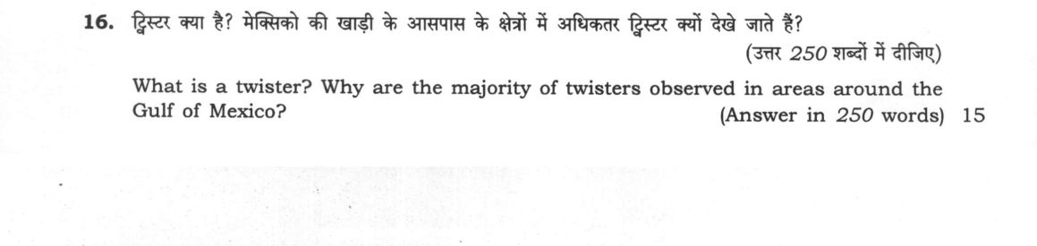
What is a twister? Why are the majority of twisters observed in areas around the Gulf of Mexico? (Answer in 250 words) 15
हिंदी में प्रश्न पढ़ें
ट्विस्टर क्या है? मैक्सिको की खाड़ी के आसपास के क्षेत्रों में अधिकतर ट्विस्टर क्यों देखे जाते हैं? (उत्तर 250 शब्दों में दीजिए)
Model answer
Written by UPSC Answer Check against this question's marking rubric, to the 250-word length. UPSC does not publish answers for Mains — this is one way to score well, not an official key.
A twister is a colloquial term for a tornado—a violently rotating column of air extending from the base of a cumulonimbus cloud to the ground. Characterised by extreme low central pressure and destructive winds, its intensity is measured on the Fujita and Enhanced Fujita (EF) scale.
Drivers of Twister Concentration around the Gulf of Mexico
The vast plains extending north from the Gulf of Mexico, spanning traditional Tornado Alley and Dixie Alley, experience the world's highest twister density due to distinct air-mass dynamics:
Moisture and Heat Source: The Gulf of Mexico, with sea surface temperatures exceeding 26°C, supplies buoyant, moisture-laden maritime tropical (mT) air northward.
Air Mass Collision: The flat terrain of the Great Plains lacks east-west topographic barriers, permitting the unobstructed collision of warm Gulf air with cold, dense continental polar (cP) air descending from Canada and dry air from the Rocky Mountains. This sharp boundary creates severe atmospheric instability.
Jet Stream Dynamics: Strong vertical and horizontal wind shear from the polar jet stream tilts thunderstorm updrafts, generating rotating mesocyclones within parent supercells that spawn tornadoes.
Seasonality and Shifting Patterns: Twisters peak during spring (March to May) when latitudinal temperature gradients are steepest. Recent climatic trends show an eastward shift of high-frequency zones toward the humid Southeast.
Comparative Context and Significance
In contrast, India experiences rare tornadoes—such as the deadly Bengal twisters of 1963 and 1978—because the Himalayan barrier blocks polar air incursions, preventing similar thermodynamic clashes. With climate change intensifying atmospheric instability and moisture fluxes, strengthening Doppler weather radar coverage and impact-based early warning systems is vital for disaster risk reduction.
What "Explain" is asking you to do
Make the working of something clear — what sets it off, what follows from what, and what it produces. Explain is the Commission's mechanism word: it dominates the technical papers and the “explain why” stems, where the marks sit in the causal chain and not in the label.
Structure that answers it
State what it is → the initiating condition → the chain of cause, step by step → an instance where it plays out → what the chain produces
Where marks are lost
Describing what something looks like instead of why it works that way. Naming the stages without linking them reads as description too.
How this answer will be evaluated
Approach
Framework: Geography: mechanism first, location follows. explain: definition/context > points in order > small example > short close Full marks: Precise definition plus clear mechanism of air mass convergence and jet stream shear.
Key points expected
- Define twister as a rotating air column
- Explain warm Gulf air mass convergence
- Mention dry air from Rockies/Plains
- Link jet stream shear to tornado formation
Evaluation rubric
Each sub-part is marked on its own, against the marks and word limit printed on the paper.
- The answer Define twister and explain the meteorological conditions causing high frequency in the Gulf of Mexico. 15 marks · 250 words
explain— definition/context → points in order → small example → short close
Must cover
- Define twister as a rotating air column
- Explain warm Gulf air mass convergence
- Mention dry air from Rockies/Plains
- Link jet stream shear to tornado formation
Loses marks
- Confusing twister with hurricane
- Listing locations without explaining mechanism
- Vague description of air masses
Earns more
- Mention 'Tornado Alley' location
- Reference spring seasonality
- Mention CAPE (Convective Available Potential Energy)
- Reference specific states like Texas/Oklahoma
Extra mark
- Sketch map of Tornado Alley
- Cite specific annual average statistics
Practice this exact question
Write your answer and it is marked point by point against the model answer above — what you covered, what you missed, what you got wrong.
Evaluate my answer →More from General Studies 2024 GS Paper I
- Q13 How far was the Industrial Revolution in England responsible for the decline of handicraf…
- Q14 The groundwater potential of the gangetic valley is on a serious decline. How may it affe…
- Q15 What are aurora australis and aurora borealis? How are these triggered? (Answer in 250 wo…
- Q16 What is a twister? Why are the majority of twisters observed in areas around the Gulf of…
- Q17 What is regional disparity? How does it differ from diversity? How serious is the issue o…
- Q18 Despite comprehensive policies for equity and social justice, underprivileged sections ar…
- Q19 Globalization has increased urban migration by skilled, young, unmarried women from vario…