Paper II — Q5
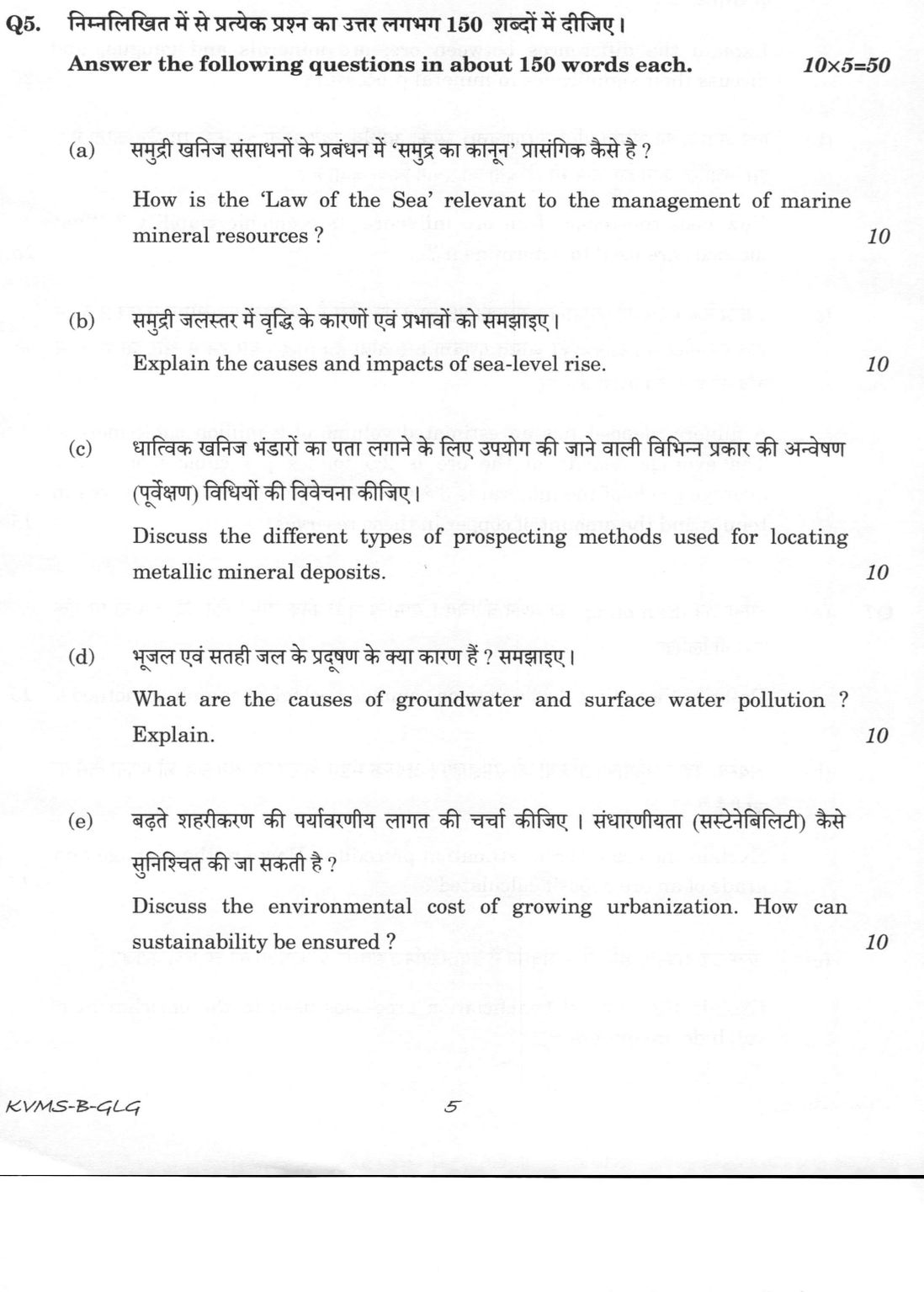
(a) How is the 'Law of the Sea' relevant to the management of marine mineral resources ? (10 marks) (b) Explain the causes and…
Answer the following questions in about 150 words each.
How is the 'Law of the Sea' relevant to the management of marine mineral resources ? 10 marks
Explain the causes and impacts of sea-level rise. 10 marks
Discuss the different types of prospecting methods used for locating metallic mineral deposits. 10 marks
What are the causes of groundwater and surface water pollution ? Explain. 10 marks
Discuss the environmental cost of growing urbanization. How can sustainability be ensured ? 10 marks
हिंदी में प्रश्न पढ़ें
निम्नलिखित में से प्रत्येक प्रश्न का उत्तर लगभग 150 शब्दों में दीजिए।
समुद्री खनिज संसाधनों के प्रबंधन में 'समुद्र का कानून' प्रासंगिक कैसे है ? (10 अंक)
समुद्री जलस्तर में वृद्धि के कारणों एवं प्रभावों को समझाइए। (10 अंक)
धात्विक खनिज भंडारों का पता लगाने के लिए उपयोग की जाने वाली विभिन्न प्रकार की अन्वेषण (पूर्वेक्षण) विधियों की विवेचना कीजिए। (10 अंक)
भूजल एवं सतही जल के प्रदूषण के क्या कारण हैं ? समझाइए। (10 अंक)
बढ़ते शहरीकरण की पर्यावरणीय लागत की चर्चा कीजिए । संधारणीयता (सस्टेनेबिलिटी) कैसे सुनिश्चित की जा सकती है ? (10 अंक)
Model answer
Drafted with AI by UPSC Answer Check against this question's marking rubric, to the 150-word length. UPSC does not publish answers for Mains — this is one way to score well, not an official key. How we build rubrics and answers.
(a) Law of the Sea and marine mineral resources (10 marks)
The UN Convention on the Law of the Sea (UNCLOS, 1982) divides the ocean into zones with different ownership of minerals.
- Territorial sea (12 nautical miles) and contiguous zone (24 nm): full sovereignty in the first.
- Exclusive Economic Zone (200 nm): sovereign rights over living and non-living resources, including seabed minerals and hydrocarbons.
- Continental shelf: rights up to 200 nm, extendable to about 350 nm on submission to the Commission on the Limits of the Continental Shelf.
- Area: seabed beyond national jurisdiction, the "common heritage of mankind", administered by the International Seabed Authority (Kingston), which licenses exploration of nodules, sulphides and crusts and shares benefits.
India ratified UNCLOS in 1995, has an EEZ of over two million km², holds an ISA contract for polymetallic nodules in the Central Indian Ocean Basin, and another for polymetallic sulphides on the Indian Ocean ridges.
(b) Causes and impacts of sea-level rise (10 marks)
Causes.
- Global (climatic): thermal expansion of warming ocean water and melting of glaciers and the Greenland and Antarctic ice sheets, which add water.
- Local (relative rise): land subsidence from groundwater extraction, sediment compaction in deltas, and tectonic movement.
The global mean rate has risen from about 1.5 mm per year in the twentieth century to nearly 4 mm per year at present, and the sea has risen about 20 cm since 1900.
Impacts.
- Physical: coastal inundation, erosion, stronger storm surges, and saline intrusion into aquifers and river deltas.
- Ecological: loss of mangroves, coral reefs and wetlands.
- Socio-economic: displacement, damage to ports, cities and farmland, and loss of livelihood. Low islands, such as the Maldives and Lakshadweep, the Sundarbans and cities such as Mumbai and Kolkata are especially exposed.
(c) Prospecting methods for metallic mineral deposits (10 marks)
Prospecting proceeds from reconnaissance to detailed work, using four groups of methods.
- Geological: regional and detailed mapping, study of outcrops, gossans, float and indicator minerals, and rock and structure controls, followed by pits and trenches.
- Geochemical: analysis of soil, stream sediment, rock, water and plants for the ore metals and pathfinder elements, to trace dispersion haloes and anomalies.
- Geophysical: magnetic surveys (magnetite, chromite), gravity (dense massive ores), electrical resistivity and induced polarisation (disseminated sulphides), self-potential and electromagnetic methods (conductive sulphides), and radiometric surveys (uranium).
- Drilling and sub-surface: core drilling and borehole logging to test anomalies, prove depth and grade, and estimate reserves.
Remote sensing supports the early stages by mapping structure and alteration zones.
(d) Causes of groundwater and surface-water pollution (10 marks)
Surface water.
- Point sources: domestic sewage and industrial effluent discharged into rivers and lakes.
- Diffuse sources: agricultural runoff with nitrate, phosphate and pesticides, urban runoff, and solid waste.
- Mining, acid mine drainage, oil spills, thermal discharge and sediment load.
Groundwater.
- Leachate from landfills, septic tanks, fertiliser and industrial lagoons, with nitrate as the common pollutant.
- Mining and over-pumping, which draw saline or polluted water into aquifers.
- Geogenic contamination, which dominates the Indian problem: fluoride from fluoride-bearing minerals in Rajasthan, Andhra Pradesh, Telangana and Karnataka, and arsenic from reduced alluvial sediments of the Ganga–Brahmaputra plains in West Bengal and Bihar, along with iron, uranium and salinity.
Groundwater pollution is slow to appear and hard to reverse, whereas surface pollution is fast and visible.
(e) Environmental cost of urbanisation and sustainability (10 marks)
Environmental costs.
- Land: loss of farmland, wetlands and forests, and the building of impervious surfaces that raise runoff and flood risk (Chennai 2015).
- Air: vehicles and industry cause pollution, and the urban heat island effect.
- Water: large demand, groundwater depletion, less recharge, and polluted sewage.
- Geology: land subsidence from groundwater withdrawal, construction on hazard-prone slopes and floodplains, and sand and stone mining.
- Waste: large volumes of solid, construction and sewage waste.
Ensuring sustainability.
- Master planning and zoning, using geological hazard maps and preserving green space and wetlands.
- Rainwater harvesting, artificial recharge, and recycling of wastewater.
- Public transport, waste segregation and recycling, and efficient use of construction materials.
- Strong local governance, enforcement and public participation, with geoscientific input into planning.
How this answer will be evaluated
Evaluation rubric
Each sub-part is marked on its own, against the marks and word limit printed on the paper.
- (a) How is the Law of the Sea relevant to the management of marine mineral resources? (10 marks, about 150 words). 10 marks · 150 words
Must cover
- UNCLOS 1982 zones: territorial sea 12 nm, contiguous zone 24 nm, EEZ 200 nm, continental shelf
- Sovereign rights over seabed minerals in the EEZ and shelf
- The Area as common heritage of mankind under the International Seabed Authority
- Indian application: ratification, nodule and sulphide contracts
Loses marks
- Confusing EEZ with territorial sea.
- No reference to the Area.
Earns more
- Correct distances for each zone.
- ISA licensing and benefit sharing.
Extra mark
- Extended continental shelf claim to CLCS
- (b) Explain the causes and impacts of sea-level rise (10 marks, about 150 words). 10 marks · 150 words
Must cover
- Global causes: thermal expansion and melting of glaciers and ice sheets
- Local causes of relative rise: subsidence, groundwater withdrawal, tectonics
- Physical impacts: inundation, erosion, surge, saline intrusion
- Ecological and socio-economic impacts with examples
Loses marks
- Naming only melting of ice as the cause.
- No impacts given.
Earns more
- Rate of rise given.
- Indian examples such as the Sundarbans or Mumbai.
Extra mark
- Adaptation measures
- (c) Discuss the different types of prospecting methods used for locating metallic mineral deposits (10 marks, about 150 words). 10 marks · 150 words
Must cover
- Geological methods: mapping, gossans, indicator minerals, pits and trenches
- Geochemical methods: soil, stream sediment and pathfinder elements
- Geophysical methods: magnetic, gravity, electrical, IP, EM, radiometric, with the ore each detects
- Drilling and sub-surface methods
Loses marks
- Listing methods without what each detects.
- Describing exploration for oil only.
Earns more
- Matching of each method to a type of ore.
- Sequence from reconnaissance to detailed work.
Extra mark
- Remote sensing
- (d) What are the causes of groundwater and surface-water pollution? Explain (10 marks, about 150 words). 10 marks · 150 words
Must cover
- Surface water: sewage, industrial effluent, agricultural runoff, mining
- Groundwater: leachate from landfills, septic tanks and fertiliser, and over-pumping
- Geogenic fluoride and arsenic with Indian regions
- Comparison of the two
Loses marks
- Treating only one of surface or groundwater.
- Omitting geogenic causes.
Earns more
- Point and diffuse sources distinguished.
- Named regions for fluoride and arsenic.
Extra mark
- Nitrate and uranium in groundwater
- (e) Discuss the environmental cost of growing urbanisation. How can sustainability be ensured? (10 marks, about 150 words). 10 marks · 150 words
Must cover
- Costs on land, air, water and geology, and waste
- Impervious surfaces, floods, subsidence and groundwater depletion
- Sustainability measures: planning, zoning, harvesting, recycling
- Governance and geoscientific input
Loses marks
- Only listing costs with no measures.
- Vague slogans with no specific measure.
Earns more
- An example such as the Chennai floods.
- Both halves of the question answered.
Extra mark
- Green infrastructure and public transport
What "How" is asking you to do
Set out the route by which the outcome comes about, step by step. Many how stems ask how one thing affects another, and there the channel of transmission is precisely what is being marked.
Structure that answers it
Starting condition → step → step → outcome reached → the conditions the route depends on
Where marks are lost
Answering why it happens instead of how, the commonest single misread in the paper. An answer full of causes and significance that never traces the mechanism has answered a different question.
Practice this exact question
Write your answer and it is marked point by point against the model answer above — what you covered, what you missed, what you got wrong.
Evaluate my answer →More from Geology 2026 Paper II
- Q2 (a) Describe common minerals of igneous and metamorphic rocks, and the diagnostic feature…
- Q3 (a) Discuss the petrogenesis of carbonatite rocks. (15 marks) (b) What is metasomatic rep…
- Q4 (a) Discuss the primary processes involved in the formation of sedimentary rocks, emphasi…
- Q5 Answer the following questions in about 150 words each. (a) How is the 'Law of the Sea' r…
- Q6 (a) Explain the differences between ore, ore minerals and gangue, and discuss their signi…
- Q7 (a) Describe Sampling. Add a note on common geological sampling methods. (15 marks) (b) E…
- Q8 (a) What are the causes of earthquakes and volcanic activities ? Discuss their mitigation…